You're here: MiBSAR's home page :: Special Operations Blog :: 2010 archives
Michigan Backcountry Search and Rescue (MiBSAR)

by Michael
A. Neiger
2010 Blog archives
Read most current Special Operations Blog posts on Facebook
Missing in Michigan event scheduled for Ford Field
“Missing in Michigan”—Michigan’s first Missing Persons Day event—will be held at Detroit's Ford Field on Saturday, May 7, 2011.
This public event is open to all, particularly families of the missing and law enforcement agencies.
Victim’s families are encouraged to bring photos of the their loved ones for scanning and uploading into law enforcement databases.
DNA specialists will also be on site to collect reference samples from family members for searching and registering in the FBI’s CODIS database.
Child ID kits will be available and a candlelight ceremony commemorating Michigan’s missing will close the event.
To learn more about this event, click here.
03-07-11
MiBSAR is now on Facebook
MiBSAR is now on Facebook.
To follow MiBSAR on Facebook, click here.
03-07-11
U.S. Air Force agrees to assist MiBSAR
with analysis of unidentified plane wreckage
Introduced in 1950, the F-89 Scorpion was developed by the Northrop Corporation as an interceptor for the United States Air Force.
With a crew of two, it was powered by two Allison J35-A-35 afterburning turbojets.
It had a maximum speed of 635 miles per hour at 10,600 feet, and could fly to nearly 50,000 feet. Its armament was variously configured of 20-mm canons, 70-mm and 127-mm aerial rockets, and 3,200-pound bombs.
With a wingspan of 60 feet, it had a maximum range of nearly 1,400 miles. About 1,050 of these jet-powered night fighters were produced before the airframe was retired in 1969.Investigation of the plane wreckage discovered in White Gravel Canyon, Ontario, Canada during a 2005 expedition led by Michael Neiger continues.
MiBSAR is currently working on getting the wreckage reviewed by the U.S. Air Force to determine if it may have originated from the airframe of an F-89C Scorpion.
Based in the Upper Peninsula during this period, an F-89C disappeared off the Pukaskwa coast on November 24, 1953.
The mil-spec markings and subdued-green primer on the wreckage found are both consistent with this era military airframe.
And this airframe remains unaccounted for, and the subject of much discussion and speculation, to this day.
On February 28, 2011, Officials with the U.S. Air Force Historical Research Agency at Montgomery, Alabama's Maxwell Air Force Base—The Intellectual and Leadership Center of the Air Force—have agreed to examine the wreckage for MiBSAR.
To learn more about this investigation, click here.
02-28-11
MiBSAR hosts 23rd annual February Canadian Snowshow-&-Sledge Expedition
Seven (7) hearty winter campers participated in the 23rd annual Canadian Snowshoe-&-Sledge Expedition, successfully crossing Lake Superior Provincial Park from the mouth of the Sand River to the Agawa Canyon.
The crew.
(Photo courtesy of
Cathy Susan)The 10-day expedition ran from February 11-20, 2011.
Bridal Veil Falls,
the crown jewel
of the Agawa Canyon.
(Photo courtesy of
Cathy Susan)Read trip beta page.
Read trip discussion thread on Backpacker Magazine's Web site.
Read Mary Powell's trip journal.
View Cathy Susan's 132-image slide show.
Click here to learn more about MiBSAR's past public trips and field operations.
02-26-11
State Police: Saari "identified as the suspect" in Dusseau murder
"In a written statement issued Wednesday, police reiterated that Saari 'has been identified as the suspect in this case,'" according to the February 24, 2011 edition of the Mining Journal (Marquette, Michigan).
Click here
or on image at right
to read
February 24, 2011
Mining Journal
(Marquette, Michigan)
article.
To learn more about the Robert Dusseau homicide investigation, click here.
02-24-11
The North Face partners with MiBSAR
MiBSAR is pleased to welcome The North Face® of San Leandro, California as its latest corporate sponsor.
Never stop exploring™
—The North Face mantraFrom its humble founding in 1966 by two California hiking enthusiasts, The North Face quickly became known for its extensive line of outdoor performance gear, particularly apparel, equipment, and footwear.
The North Face
minus-40 below
Dark Star,
a mainstay on MiBSAR's
extreme operations.Today, The North Face is proud to be the first choice of the world's most accomplished climbers, mountaineers, extreme skiers, snowboarders, endurance runners, and explorers.
Rugged and dependable, The North Face gear is standard equipment for Team MiBSAR.
Click here to learn more about MiBSAR's other corporate partners.
02-05-11
SAR field operations scheduled in support of eastern Upper Peninsula law enforcement agencies
2-01-11
MiBSAR hosts 5-day January, 2011 Winter-Camping Trip
Thirteen (13) hearty winter campers participated in the 5-day Kingston Plains Winter-Camping Trip and long-range SAR field training operation hosted by MiBSAR in the eastern Upper Peninsula's Lake Superior State Forest from January 14-18, 2011.
The crew.
(Photo courtesy of
Mary Ann Hayman)Read trip beta page.
Read trip discussion thread on Backpacker Magazine's Web site.
Read Gail Staisil's photo journal.
View Mary Ann Hayman's 127-photo, 7-video slide show.
View Dave Goodyear's 28-image slide show.
View Gail Staisil's 54-image slide show.
View Cathy Susan's 47-photo, 1-video slide show.
View Chris Ozminski's YouTube highlights reel.
View Matt Acker's 66-image slide show.
View Matt Acker's YouTube sled cam videos: reel 1, reel 2, & reel 3.
Click here to learn more about MiBSAR's past public trips and field operations.
01-23-11 (01-24)
Dusseau Homicide rated no. 2 news story for 2010 in Upper Peninsula's largest newspaper
The pawn shop robbery in which Robert Dusseau was murdered was rated as the no. 2 news story for 2010 in the December 31, 2010 edition of the Mining Journal (Marquette, Michigan).
Click here to read the entire story.
Click here to read more media coverage of the Robert Dusseau homicide.
Click here to visit the Robert Dusseau investigative Web site.
12-31-10
Chris Ozminski produces documentary film on MiBSAR's operations
A mini documentary film about MiBSAR and its field operations has been produced and uploaded to YouTube by Team MiBSAR member Chris Ozminski.
Click here to check out another fine piece of cinematography by Chris.
12-23-10
Dusseau homicide suspect sentenced to 9 years in federal prison on unrelated weapons charges
The December 15, 2010 edition of the Mining Journal (Marquette, Michigan) reported A Marquette man who remains a police suspect in the shooting death of a local gun shop owner was sentenced Tuesday to serve nine years, seven months in federal prison for being a felon in possession of firearms....
Click here to read the entire story.
Click here to visit the Robert Dusseau investigative Web site.
12-16-10
MiBSAR donates cartographic services in support of 2011 Noquemanon Ski Marathon
Through its Extreme Maps for Extreme Races community outreach program, MiBSAR donated its cartographic services in support of the 2011 running of the Noquemanon Ski Marathon, creating a full-color route map for this 50-kilometer race as well as detailed, 1:24,000-scale section maps for each of the races eight stages.
Click here
or on graphics
at right to view
high-resolution imagery
of 50-km race route.
(Cartography by
Michael Neiger)The scenic, 50-kilometer, bush route traversed by the marathon runs from Ishpeming to Marquette in the central Upper Penninsula of Michigan.
12-09-10
Asolo partners with MiBSAR
MiBSAR is pleased to welcome Asolo USA of Lebanon, New Hampshire as its latest corporate sponsor.
Since its founding in 1975, Asolo's single goal has been to create great footwear for every outdoor need, irrespective of condition or altitude.
The Triple Power Structure (TPS) 535 boot by Asolo.
Asolo offers a wide range of hiqh-quality footwear suited for technical alpinism, hiking, and trekking. Its alpine boots have conquered some of the most challenging mountains in the world.
Rugged Asolo footwear is the first choice for many Team MiBSAR volunteers.
Click here to learn more about MiBSAR's other corporate partners.
12-09-10
MiBSAR hosts Dec '10 Michigan Backpacking Rendezvous
12 backpackers participated in the 4-day Michigan Backpacking Rendezvous and long-range SAR training operation hosted by MiBSAR in the Lower Peninsula of Michigan's Pigeon River Country State Forest from December 4-7, 2010.
The crew, less Ewa.
(Photo courtesy of
Mary Ann Hayman)
View Mary Ann Hayman's 64-image, 1-video slide show or photo album from this rendezvous.View Ewa Roszczenko's 36-image slide show
View Matt Acker's 28-image slide show.
Click here to learn more about MiBSAR's past public trips and field operations.
12-09-10 (rev. 01-25)
MiBSAR solves 40-year-old cold case on Isle Royale
After two years of sleuthing, MiBSAR was able to solve the 40-year-old disappearance of Robert Kyle on Isle Royale in northwestern Lake Superior.
To learn more about how this baffling cold case in one the Nation's remotest national parks was solved, click here.
11-21-10
Lowe Alpine is MiBSAR's latest corporate partner
MiBSAR is pleased to welcome Lowe Alpine of Lebanon, New Hampshire as its latest corporate sponsor.
A pioneer in outdoor gear manufacturing, Lowe Alpine was founded in 1967 in a Colorado work shed by Greg Lowe, an avid climber, along with help from his brothers, Jeff and Mike. Greg's first internal-frame rucksacks revolutionized the pack industry.
Today, Lowe Alpine is an international company staffed by rock climbers, alpinists, mountain bikers, skiers, trail runners, and kayakers.
The hard-to-find,
4-pound, 10-ounce
95-liter FTX Expedition
rucksack by Lowe Alpine.Sold in more than 30 countries, Lowe Alpine's innovative, high-quality products include a complete line of rucksacks—from 15 liters to 95 liters—for hiking, travel, backpacking, mountaineering, and military operations.
Click here to learn more about MiBSAR's other corporate partners.
11-19-10
Investigation of White Gravel Canyon plane wreckage continues
Investigation of the plane wreckage discovered in White Gravel Canyon, Canada during a 2005 expedition led by Michael Neiger continues.
MiBSAR is currently working on getting the wreckage reviewed by a panel of military aviation experts to determine if it may have originated from the airframe of an F-89 Scorpion. The mil-spec markings and subdued-green primer are both consistent with this era military airframe.
Based in the Upper Peninsula during this period, one F-89 disappeared off the Pukaskwa coast on November 24, 1953. It remains unaccounted for, and the subject of much discussion, to this day.
Introduced in 1950, the F-89 Scorpion was developed by the Northrop Corporation as an interceptor for the United States Air Force. With a crew of two, it was powered by two Allison J35-A-35 afterburning turbojets. It had a maximum speed of 635 miles per hour at 10,600 feet, and could fly to nearly 50,000 feet. Its armament was variously configured of 20-mm canons, 70-mm and 127-mm aerial rockets, and 3,200-pound bombs. With a wingspan of 60 feet, it had a maximum range of nearly 1,400 miles. About 1,050 of these jet-powered night fighters were produced before the airframe was retired in 1969.
To learn more about this investigation, click here.
11-12-10UK's Intelligent Holdings supports MiBSAR's operations
MiBSAR is pleased to welcome Intelligent Holdings of Gloucestershire, UK as its newest corporate sponsor.
Intelligent Limited, through its subsidiary Intelligent Armour, is an international exporter of a full range of tactical and covert gear to the British Government, national and international police forces, military units, private security firms, and others serving in hostile environments.
The hard-to-find Karrimor Special Forces Rucksacks.
In addition to manufacturing its own hi-tech body armour, ballistic plates, and helmets, Intelligent Armour distributes a wide array of state-of-the-art gear from leading companies such as:
- Oakley SI
- Bug Out Gear
- Surefire
- Magnum
- Under Armour
- Benchmade
- Lowa
- Blackhawk
- Silva
- ESS
- 5.11 Tactical
- Timberland
- Gerber
- Fjallraven
- Spyderco
- Danner
- Under Armour
- Heckler & Koch
Through its other subsidiaries, Intelligent Limited offers worldwide security and intelligence services to Royal families, Middle Eastern governments, corporations, and individuals:
- Counter espionage
- Surveillance & reconnaissance
- Intelligence gathering
- Close protection in war zones
- Armed extraction
- Personal security drivers
- Diplomat security
- Corporate investigations
- Private investigations
- Computer forensics
- Litigation support
- Loss prevention & due diligence
Drawing on training and operational procedures developed by the UK police, military, special forces, and the British Intelligence Services, Intelligent Limited offers specialized training in surveillance, counter espionage, evasive driving, etc.
Many of Intelligent Limited's multi-lingual professionals come straight out of the British special forces, including the famed Special Air Service, or SAS.
Intelligent Limited was formed by Alex Bomberg, whose background includes service in the British Army. He was also an aid to the British Royal Family.
Click here to learn more about MiBSAR's other corporate partners.
10-27-10
MiBSAR uploads new UTM coordinate system primer to the Net
MiBSAR has uploaded a 11,000-word primer on the Universal Transverse Mercator (UTM) coordinate system to the Internet...
The Universal Transverse Mercator coordinate system—or UTM, as it's commonly referred—is a international locational reference system that depicts the Earth's three-dimensional surface in a relatively-accurate, two-dimensional manner.
Becoming proficient with the Universal Transverse Mercator (UTM) coordinate system—that is, learning to quickly and accurately calculate the UTM coordinates of a specific location on a topographic quadrangle (for input into a GPS unit) or plot UTM coordinates on a quadrangle (derived from a GPs unit)—is an essential wilderness skill.
Mastery of the UTM coordinate system is considered one of the pinnacles of achievement among seasoned wilderness land navigators.
The UTM coordinate system allows users to accurately and unambiguously identify geographical locations anywhere on the Earth's surface between the northern limits of North America (defined as 84 degrees north latitude) and the southern limits of continent of Antarctica (defined as 80 degrees south latitude)....
Developed by the US Army Map Service in the late 1940s — probably 1947 — and shortly thereafter adopted by US Army as well as North Atlantic Treaty Organization (NATO) forces, the Universal Transverse Coordinate (UTM) projection and grid system remained a classified secret for many years.
Still in use today, the civilian version retains the UTM coordinate system name while the military version carries the Military Grid Reference System (MGRS) coordinate system name....
While the LAT/LON coordinate system is the first choice of pilots, sailors, and others using less-detailed, small-scale maps to navigate over great distances, seasoned wilderness trippers, expert search-and-rescue personnel, elite fighting units, professional orienteers, and others using highly-detailed, large-scale, topographic quadrangles for technical land navigation rely almost exclusively on the geospatial plane coordinate system known as the Universal Transverse Mercator (UTM) coordinate system (or, its close relative, the Military Grid Reference System [MGRS], in the case of military).
The UTM coordinate system has become the de facto standard coordinate system among expert land navigators for technical, wilderness operations for a number of reasons....read more.
Primer table of contents....
- Introduction
- Why use the UTM coordinate system?
- History of UTM coordinate system
- UTM grid coordinate data strings
- UTM vertical grid zones
- 60 zones
- A typical zone
- UTM horizontal grid hemispheres/rows
- UTM easting coordinates
- UTM northing coordinates
- Drawing UTM grid lines on maps
- Calculating & plotting UTM coordinates
- UTM coordinates & map datums
- Coordinate format conversion
- Metric v. English conversions
- References
To learn more about the UTM coordinate system, click here.
11-06-10
Meyers Custom Supply supports MiBSAR's operations
MiBSAR is pleased to introduce Meyers Custom Supply of Cassel, California as its latest corporate partner.
Meyers' is a global distributor of SurePak MREs—meal, ready-to-eat—packed by SOPAKCO, a leading military contractor since World War II.
While the contents are heavier than freeze-dried or dehydrated rations, they're ready to eat, as is, without prep or the addition of water.
Each MRE unit has a shelf life of 5 years and is packaged to withstand wet environments as well as high-altitude drops.
A single meal unit contains an entrée, side dish, dessert item, cracker or wheat bread and spread, beverage powder, and a condiment pack with a spoon, napkin, wet nap, salt, pepper, coffee, creamer, and sugars.
MRE and First Strike Ration components available from Meyers Custom Supply include, from left to right: Bridgford pocket sandwiches, Pangea pound cakes, Pangea wheat bread, and Bridgford flat bread.
Meyer's also distributes components found in the newly-developed First Strike Ration (FSR).
Announced in 2002, First Strike Rations (FSR) were field tested by Army special operations troops and Navy SEALs before their introduction in 2007.
Their development was the result of research showing troops were field-stripping their issued MREs in an attempt to lighten their rucksack loads.
Often discarded were packaging—such as boxes, plastic bags, and wrappers—spoons, ration heaters, accessory packs, and other nonessentials.
When all was said and done, a 24-hour, 3,600-calorie ration of three MREs was reduced to between 2,500 and 2,100 calories.
First strike rations are compact, eat-on-the-move rations developed by the United States Army for consumption by forward-deployed troops during the first 72 hours of battle.
One of these new, 24-hour, shrink-wrapped, 2900-calorie assault ration units weighs about half of what three traditional MREs (a day's ration) do.
One of the primary components of First Strike Rations, which were developed at the Army's Natick Soldier Systems Center (NSSC) in Natick, Massachusetts, are ready-to-eat sandwiches (or pouch pockets) such as Bridgford Foods' Stay Fresh Sandwich.
Varying in weight from 2.5 to 3.5 ounces, and in nutritional value from 290 to 330 calories, these three-year-shelf-life pocket sandwiches are available in five flavors: honey barbecue beef, honey barbecue chicken, pepperoni, Italian style (sausage, pepperoni, & sauce), and bacon cheddar.
Other individual ration components available from Meyers Custom Supply include pound cakes, cinnamon buns, wheat bread, and flat bread. Meyers also sells a wide array of survival-related gear.
Click here to learn more about MiBSAR's other corporate partners.
10-27-10
April backpacking trip announced
MiBSAR has scheduled a free, public, 4-day, backpacking trip in the Pigeon River Country State Forest for April 2-5, 2011.
10-27-10
Seal Line® supports MiBSAR's operations
MiBSAR is pleased to introduce Seal Line® of Seattle, Washington as its latest corporate partner.
Seal Line makes first-class dry bags, packs, duffles, urban bags, map cases, and sea kayaking bags and accessories that'll keep your gear protected anywhere—from the urban jungle to the farthest reaches of the globe.
By combining the highest-quality, waterproof fabrics with their proprietary RF-welding skills, Seal Line's innovative line of gear-protection products are unmatched in the industry.
The result is unquestionable gear protection for surviving the world's most challenging environments.
And Seal Line stands behind their products, guaranteeing them for life.
Seal Line packs, dry bags, and map cases are common sights on all of MiBSAR's water-based, search-and-rescue operations.
Click here to learn more about MiBSAR's other corporate partners.
10-26-10
10-day, August 2011, Canadian canyoneering expedition planned
MiBSAR has scheduled a free, public, 10-day, Dog River Canyoneering Expedition in Ontario, Canada for August 5-14, 2011.
10-25-10
Platypus® supports MiBSAR's operations
MiBSAR is pleased to introduce Platypus® of Seattle, Washington as its latest corporate partner.
Platypus is credited with developing the original, collapsible, taste- and BPA-free hydration systems on the market.
They offer a complete line of high-quality handheld and hands-free hydration systems, water filtration products, water bottles, and storage bladders.
Platypus water bladders are used on all MiBSAR operations, especially dry ones. And they're guaranteed for life.
Click here to learn more about MiBSAR's other corporate partners.
10-22-10
9-day, May 2011, Canadian backpacking expedition planned
MiBSAR has scheduled a free, public, 9-day, Canadian backpacking expedition to the seldom-visited Michipicoten Island for May 28 to June 5, 2011.
10-19-10
March winter-camping trip announced
MiBSAR has scheduled a free, public, 5-day, winter-camping trip in the Grand Island National Recreation Area for March 3-7, 2011.
10-18-10
10-day, February 2011, Kwagama Mountain Expedition in Ontario, Canada planned
MiBSAR has uploaded complete info on the free, public, 10-day, Kwagama Mountain Expedition scheduled for February 12-21, 2011 in Ontario Canada.
Click here
or on graphic
at right for
high-resolution
imagery of
detailed route map.Starting from the mouth of the Sand River on Lake Superior's rugged, eastern shoreline, we'll pull sledges with snowshoes up into the Algoma Highlands, bivouacking on the summit of Kwagama Mountain before descending to the floor of the Agawa Canyon via a gorge in it's west wall.
After exploring the canyon and several of its glistening, frozen-in-time waterfalls, we'll flag down a passing bush train for a ride to within five, snowy miles of our vehicles.
10-17-10
MiBSAR uploads Emergency Communications Gear and Emergency Insurance web pages
MiBSAR recently uploaded web pages dedicated to Emergency communications gear as well as Emergency insurance coverage.
10-16-10
MiBSAR is pleased to introduce Therm-A-Rest® as its latest corporate sponsor
MiBSAR is pleased to introduce it newest corporate sponsor: Therm-A-Rest® of Seattle, Washington.
For over 35 years, Therm-A-Rest has been providing the finest solutions for outdoor seating and sleeping comfort.
Many MiBSAR volunteers depend on their Therm-A-Rest sleeping pads—whether closed cell or inflatable—for a good night's sleep in rugged bivouac sites after a long day of searching.
Click here to learn more about MiBSAR's corporate partners.
10-14-10
January winter-camping trip announced
MiBSAR has scheduled a free, public, winter-camping trip in the Lake Superior State Forest for January 14-18, 2011.
10-13-10
MiBSAR is pleased to introduce Mountain Safety Research® (MSR) as its latest corporate sponsor
MiBSAR is pleased to introduce it newest corporate sponsor: Mountain Safety Research (MSR) of Seattle, Washington.
For over 40 years, the MSR brand has stood for cutting-edge, backcountry-gear engineering.
MSR's passionate fusion of mountaineering and engineering has led to a succession of ground-breaking products—from stoves, tents, and snowshoes, to cookware, water filters, purifiers, and camp towels—that have revolutionized the outdoor industry.
As a result, MSR gear has been taken on expeditions around the world, standing up, time and time again, to the most demanding situations imaginable.
MSR stoves, particularly the XGK and its offspring, have been long-time mainstays for several members of the MiBSAR team.
Click here to learn more about MiBSAR's corporate partners.
10-13-10
December backpacking trip announced
MiBSAR has scheduled a free, public, winter-backpacking trip in the Pigeon River Country State Forest for December 4-7, 2010.
10-12-10
MiBSAR completes field test of All-in-One UTM Reader™ for Brooks-Range Mountaineering Equipment Co. of Fremont, California
MiBSAR recently completed a field test of a Universal Transverse Mercator (UTM) roamer scale on steroids—the All-in-One UTM Reader™—at the request of the manufacturer, Brooks-Range Mountaineering Equipment Co., of Fremont, California.
The Brooks-Range All-in-One UTM Reader™
Click here or on image above to view high-resolution imagery of Brooks-Range's All-in-One UTM Reader™
MiBSAR volunteer Ewa Roszczenko of Livonia, Michigan uses Brooks-Range's UTM Reader™ with a USGS quad during an October search for Raymond Perry in the Miners River Valley of Pictured Rocks National Lakeshore. (Photo by Michael Neiger)
The UTM Reader™ is made from 16-mil (0.016 inch) clear plastic that's flexible enough to carry in a pocket, but tough enough to handle rough field use, even in subzero temperatures.
Printed in two colors—high-contrast red and black—on non-glare material, the plotter is easy to read in direct sunlight.
At 4.25 by 7 inches (108 x 178 mm) in size, it fits easily into a shirt pocket or waist-belt pouch for quick access.
Weighing a mere 0.4 ounces (11.34 grams), this ultralight, all-in-one land navigation tool is packed with an amalgamation of grids, scales, indices, rules, compass roses, and conversion data for backcountry travelers.
It retails for $11.95.
11 UTM plotters
As its name rightly implies, the UTM Reader™ includes eleven UTM corner rulers, or roamer scales:
Map scale: Tick marks: 1;20,000 10 meters 1:24,000 10 meters 1:25,000 10 meters 1:30,750 10 meters 1:50,000 50 meters 1:62,500 100 meters 1:63,360 100 meters 1:100,000 100 meters 1:125,000 50 meters 1:150,000 100 meters 1:250,000 100 meters The 1:50,000-, 1:62,500-, 1:63,360-, 1:100,000-, 1:125,000-, 1:150,000-, and 1:250,000-scale roamers include extended scales that can be used as distance-measuring rulers.
In addition to 11 corner rulers, this land-nav tool also includes a square, 1:24,000-scale, 1,000-meter grid overlay. Placed over a kilometer grid square on a quadrangle, users can quickly and effortlessly subdivide the grid into its onehundrd constituent 100-meter grid squares for rapid coordinate plotting.
While the UTM Reader™ is designed to be accurate to 1/50th of an inch—about the size of a sentence period, the current USGS cartographic standard—and it's been reviewed for accuracy by mountaineers, ski guides, avalanche experts, and professional cartographers, Brooks-Range cautions users to be realistic when using a UTM roamer scale with a quadrangle:
Free land nav tools courtesy of Brooks-Range...
If you've been looking for a source for free land navigation tools, ones you can print out yourself, click here to see Brooks-Range's offering of compass roses, UTM grid corner
plotters, UTM grid overlays, even a handy 3x3 Avalanche Assessment Process & Reduction Method card.
At Brooks-Range, we understand that trip planning and navigation are dependent upon the accuracy of maps and the [UTM Reader™], as well as the skill of the traveler. In developing the [UTM Reader™], we used state-of-the-art computer drafting techniques under the guidance of a cartographer. We worked with the production team to maintain the accuracy designed into the [UTM Reader™]. We beta-tested the [UTM Reader™] in the field. Our goal is to provide the most accurate tool on the market – and to the best of our knowledge, we have succeeded!
However, even the most accurate tools have limitations. As a backcountry traveler, understand the limitations inherent in maps and map reading so you can make informed, sound judgments.
The U.S. Geological Survey (USGS) horizontal accuracy standard for most topographic maps is 1/50th inch – about the size of the period at the end of this sentence. The error, using a 1:24,000 scale, is +/- 40 feet on the ground; and using a 1:100,000 scale, is +/- 167 feet. (This USGS map standard applies only at well defined points such as stream intersections, crossroads or summits. Errors in maps for less well defined features could well be much larger.) In these days of GPS, these errors may seem large. Given average human eyesight, even the most careful [UTM Reader™] user is unlikely to be able to distinguish readings closer than 1/50th inch.
13 slope angle scales
Map scale: Contour interval: 1;20,000 20 foot 1:24,000 40 foot 1:25,000 10 & 20 meter 1:30,750 40 foot 1:50,000 20 & 40 meter 1:62,500 100 foot 1:63,360 100 foot 1:69,500 80 foot 1:100,000 50 meter 1:125,000 100 foot 1:250,000 200 foot The UTM Reader™ includes 13 slope-angle scales for gauging terrain slope directly from a quadrangle.
Click here to view and print Brooks-Range's free 3x3 Avalanche Assessment Process & Reduction Method card
Field-expedient inclinometer: By design, the compass rose described on the UTM Reader™ below can double as an inclinometer for measuring slope angles in the field, directly from the terrain, if a small hole is punched in the exact center of the rose and an 8-inch-long piece of colored string is threaded through it.
To keep the thread from falling out, one end should be knotted. To allow the thread to hang taught and straight down, attach a small weight to the other end (complete instructions for preparing and using the compass rose as an inclinometer are included with the purchase of each UTM Reader™).
Compass rose
Near the center of the UTM Reader™ isa large compass rose. This circular protractor accommodates angular measurements in both degrees and mils.
Click here or on
image to view
high-resolution imagery
of the compass rose
on Brooks-Range's
All-in-One UTM Reader™
In addition to the common cardinal and intercardinal notations, the outside of the compass rose consists of a 360-degree circle equally subdivided with one-degree-interval tick marks.
The inside of the compass rose consists of a 6,400-mil circle equally subdivided with 20-mil-interval tick marks.
Mil compass roses are popular among military types—particularly artillerists, or canon cockers—since they're far more discriminating, especially over long distances, than degree compass roses. (One degree on a 360-degree compass rose is represented by nearly 18 mils on a 6,400-mil compass.)
Compass roses like the one on the UTM Reader™ are essential for wilderness trippers using non-baseplate compasses, ones that can't double as a protractor for plotting and calculating azimuths on quadrangles.
Metric/English conversion equivalents
The UTM Reader™ is also imprinted with the following metric/English conversion equivalents:
- Centimeters to inches; inches to centimeters
- Meters to feet; feet to meters
- Kilometers to miles; miles to kilometers
The field test results
The Brooks-Range All-in-One UTM Reader™ is definitely a professional-grade map tool designed for in-the-field use with a wide variety of quadrangles.
Vetted by professional mountaineers, avalanche experts, ski guides, and learned cartographers alike, the UTM Reader™ is a very accurate way for wilderness travelers to plot UTM coordinates, gauge slope angles, measure distances, and compute quadrangle azimuths, whether they're operating in the United States, Canada, or overseas.
When MiBSAR overlaid the UTM Reader's corresponding roamer scales on the marginal scales of both a USGS 1:24,000-scale quad and a Canadian 1:50,000-scale quad—the staples of most wilderness trippers—they matched perfectly, even under magnification.
And unlike the eight other commercial UTM roamer scales in MiBSAR's field kit, the Brooks-Range UTM Reader™ was the only one up to the task of calculating and plotting UTM coordinates on 1:20,000-scale Ontario Provincial Base Maps, maps vital to the success of MiBSAR's nine-day, August 2010, Soldier Mountain Expedition. Not one of the other commercial map tools offered a roamer scale suitable for use on 1:20,000 quads.
The UTM Reader™ is certainly a big improvement over a lot of the map tools on the market today, many of which are only suitable for desktop applications as they're too cumbersome, too heavy, or just too fragile for rough handling or harsh conditions, particularly the subzero temperatures encountered on many expeditions.
And for those not accustomed to the UTM system, or using roamer scales, slope indices, or compass roses with quadrangles, they'll appreciate the concise—but in-depth—9-page Instruction Guide Brooks-Range includes for free with the purchase of every UTM Reader™.
Lightweight and very durable, the UTM Reader™ is destined to meet or exceed the expectations of seasoned wilderness guides and novice backpackers alike.
It's the best map tool MiBSAR has used to date, and it's become the SAR group's go-to map tool for planning and executing challenging wilderness operations.
And when it's not in use, it makes a classy bookmark!
The company behind the UTM Reader™
Brooks-Range is a leading manufacturer of mountaineering and outdoor equipment, much of it high-end, specialized mountaineering gear that's become a favorite of backcountry professionals, especially search-and-rescue team members, ski guides, and ski patrollers.
It's innovative, top-quality, backcountry gear has been field tested by some of the world's top mountaineering, avalanche, and backcountry professionals, many of whom form the core of the company's Advisory Board.
Brooks-Range is a proud supporter of organizations promoting wilderness education and safety including the:
- American Mountain Guide Association
- Association of Canadian Mountain Guides
- American Avalanche Association
- Canadian Avalanche Association
- American Institute for Avalanche Research and Education
A privately-held company, Brooks-Range was founded in 1995 by Matt Brooks, an avid mountaineer, certified mountain guide, and member of the American Mountain Guides Association.
Matt is credited with the first ascent of the Galactic Hitchhiker, the longest technical rock climb in North America.
In addition, Matt holds US national and international aviation records for Speed Around the World, C-1 & C-1.d, Group III.
He also holds 68 US national and international aviation records, including Distance without Landing and Trans-Continent Speed.
Brooks-Range Mountaineering Equipment Co. contact info:
- Phone: 1-781-585-1717
- Snail mail: 4725 Thornton Avenue, Fremont, California, 94536
- E-mail: info@brooks-range.com
- Web site: www.brooks-range.com
10-11-10
MiBSAR donates cartographic services in support of 2011 Marquette Trail 50 Ultra-Marathon race
MiBSAR donated its cartographic services in support of the 2011 running of the Marquette Trail 50 Ultra-marathon, creating detailed, full-color route maps for both the 32-mile (50-km) and 50-mile (83-km) races.
Click here
or on graphic
at right to view
high-resolution imagery
of 32-mile (50-km)
race route.
(Cartography by
Michael Neiger)The scenic 32-mile route involves over 4,500 feet of elevation change.
The more arduous 50-mile route challenges runners with over 6,100 feet of elevation change.
Click here
or on graphic
at right to view
high-resolution imagery
of 50-mile (83-km)
race route.
(Cartography by
Michael Neiger)Both routes pass by the Dead River Falls, ascend Sugarloaf Mountain and Top of the World, and traverse miles of Lake Superior shoreline.
Team MiBSAR plans to participate in the 50-mile race in 2011.
10-09-10
MiBSAR completes 3-day SAR training operation at Pictured Rocks National Lakeshore
In addition to visiting waterfalls—including Upper Mosquito Falls (at right)—MiBSAR went spelunking, spending considerable time working dozens of grottos in the western escarpment of Chapel Basin.
Click here to view Mary Powell's slide show.
10-08-09
MiBSAR field manual—Lost Alzheimer's Disease Search Management
Lost Alzheimer's Disease Search Management: A Law Enforcement Guide to Managing the Initial Response and Investigation of the missing Alzheimer's Disease Subject, by Robert J. Koester (dbS Productions, Charlottesville, Virginia, 1999, $75.00, 160 pages,
ISBN: 1-879471-34-5)
About the author...
Robert J. Koester, Ph.D., is a neurobiologist who has authored numerous articles and books on wandering and the lost Alzheimer's disease subject. He's also presented papers and talks around the world on the subject.
His contributions to search and rescue include seminal research on lost person behavior (with an emphasis on dementia) and the development of the International Search and Rescue Incident Database (ISRID).
Robert joined the Appalachian Search & Rescue Conference in 1981 and has participated in hundreds of searches. He also served as president of the Virginia Search and Rescue Council for 15 years.
In addition to conducting wandering research, he's a type-1 incident commander; a technical instructor with the Virginia Department of Emergency Services; an instructor with the Virginia Department of Criminal Justice; on the board of directors of the Appalachian Search & Rescue Conference; and a consultant with dbS Productions in Charlottesville, Virginia.
MiBSAR's latest, authoritative missing-person field manual is: Lost Alzheimer's Disease Search Management: A Law Enforcement Guide to Managing the Initial Response and Investigation of the missing Alzheimer's Disease Subject.
Authored by Dr. Robert J. Koester, Lost Alzheimer's Disease Search Management was published in a three-ring-binder format in 1999 by dbS Productions of Charlottesville, Virginia. ($75.00, 160 pages, ISBN: 1-879471-34-5)
Contents... Plan of Instruction Background Introduction Scope of Wandering Problem Search Management Incident crucials Characteristics of Lost Alzheimer's Subjects Initial Report collection and Action Initial Search Strategy Reflex Tasking of SAR Resources Case studies Case Histories & Map Problems Student Handouts This 160-page manual includes an exhaustive Glossary as well as several appendices: Suggested Reading, Sample Test Questions, Suggested Web Sites, Wandering Program Bibliography& References, and NCIC Report.
For those wishing to instruct others on managing missing-person cases involving Alzheimer's disease patients, the manual includes lesson outlines, slide masters, and a CD for PowerPoint presentations.
Lost Alzheimer's Disease Search Management is currently the definitive guide to investigating missing Alzheimer's patients.
It is available from Amazon.Com for $100.00 and directly from the publisher—dbS Productions—for $75.00.
10-06-10
MiBSAR welcomes Ewa Roszczenko of Livonia, Michigan as its newest volunteer searcher
MiBSAR is pleased to welcome Ewa Roszczenko of Livonia, Michigan as its newest volunteer searcher.
A former mountain climber, she currently organizes and leads wilderness trips across the U.S. for the Michigan Chapter of the Sierra Club.
In May and August of this year respectively, Ewa completed two of MiBSAR's most arduous Canadian backpacking expeditions: the 9-day Exploratory Coastal Expedition in Lake Superior Provincial Park and the 9-day Soldier Mountain Expedition in Pukaskwa National Park.
A doctor of pharmacy at the US Department of Veterans Affairs' hospital in Ann Arbor, Michigan, Ewa—pronounced Eva—brings a wealth of pharmacological knowledge and wilderness skills to MiBSAR's investigations and long-range, field operations.
10-05-10
MiBSAR recovers logging-era artifacts for interpretive use at Tahquamenon Falls State Park
MiBSAR volunteers recovered two, old, logging-era artifacts during a late-September SAR field operation in the Timberlost region of Tahquamenon Falls State Park.
MiBSAR volunteer
Larry Bryan
of Bath, Michigan
holds the cant-hook
he helped recover
along an old railroad spur
east of the Timberlost Road,
an old, logging-era
railroad grade.
(Photo by Michael Neiger)Recovered were a cant-hook, which loggers used to manhandle logs, and a very-old porcelain sign warning Tractors with Lugs to Keep Off the Timberlost Road under penalty of state law.
The old, porcelain
road sign recovered
by MiBSAR along
the Timberlost Road.
(Photo by Michael Neiger)After the items were photographed, measured, and precisely located with a global positioning system (GPS) unit, they were collected and turned over to park staff for interpretive use.
09-30-10.
MiBSAR launches investigative Web site and designs missing-person poster in support of the Alger County Sheriff Department's investigation into the disappearance of Raymond Perry in the Pictured Rocks National Lakeshore
MiBSAR will be assisting the Alger County Sheriff's Department with their investigation into the disappearance of Raymond Wallace Perry.
Perry, age 85, has been missing in the Pictured Rocks National Lakeshore buffer zone—the upper reaches of the Miner's River Basin—since August 23, 2006.
Click here
or on image at right
to view
Raymond Wallace Perry's
investigative Web site.Stricken with Alzheimer's, Raymond has not been seen or heard from since he walked away from his Monette Road home, which is located north of Alger County Road H-58, just west of the Miner's River.
At the time he went missing Raymond was 85 years old.
He was reportedly wearing a long-sleeved, plaid shirt; dark-colored blue jeans with blue, one-inch-wide suspenders; dirty white, low-cut, size 10, tennis shoes; and probably a tan or light-brown baseball cap.
MiBSAR has designed and uploaded an investigative Web site and created a missing-person poster in support of the Sheriff's investigation into this baffling case.
Click here
or on image at right
to view
Raymond Wallace Perry's
missing-person poster.MiBSAR will also be conducting extensive ground search operations in the Miner's River Basin.
09-27-10
Person of interest in Dusseau homicide pleads guilty to unrelated federal gun charges in U.S. District Court
"Ryan Daniel Saari, 34, pleaded guilty to the federal charge of being a felon in possession of a firearm," according to the September 21 , 2010 edition of the Mining Journal (Marquette, Michigan).
Click here
or on image at right
to read
September 18, 2010
"Plea bargain" article.Home invasion charges as well felonious assault charges—he was "accused of attacking his ex-girlfriend Jamie Bodnar with a knife—were dismissed by the Marquette County Prosecutor's office.
According to the Journal, "Michigan State Police troopers have said they cannot eliminate Saari as a 'person of interest' in the Feb. 23 shooting death of Robert Anthony Dusseau at the Quik Cash and Guns shop in Marquette Township."
Click here
or on image at right
to read
September 21, 2010
"Saari pleads" article.To learn more about the Robert Dusseau homicide investigation, click here or on investigative poster at right.
09-21-10 (rev. 09-22)
MiBSAR awarded Homeland Security grant monies for purchase of Magellan Triton 2000 GPS unit
MiBSAR was recently awarded Region 8 Homeland Security grant monies for the purchase of a state-of-the-art global positioning unit (GPS) from Magellan GPS .
Intended for use on MiBSAR investigations and search-and-rescue field operations conducted in support of Upper Peninsula of Michigan law enforcement agencies and victim's families, the Magellan® Triton™ 2000 just acquired is pictured on the right.
Among its most important features is its ability to give users real-time plots on original, 1:24,000-scale, USGS, digital quadrangles that can be edited and annotated with search sectors, private property boundaries, trails, roads, etc.
No other GPS unit on the market—including those in the popular GARMIN line—are known to allow a user to load 1:24,000 USGS digital quads that have been custom-annotated as needed for technical land nav operations.
09-15-10
MiBSAR completes field test of Ultralite™ Guide-Plus Tarp™ for Brooks-Range Mountaineering Equipment Co. of Fremont, California
Brooks-Range Mountaineering Equipment Co., of Fremont, California contacted MiBSAR about field testing one of their new Ultralite™ tarps on June 24, 2010.
MiBSAR welcomed the opportunity since Brooks-Range Mountaineering is probably the only manufacturer to offer a wide variety of ultra-light tarps in a camouflage pattern suitable for subdued operations in wilderness areas.
The tarp...
The Ultralite™ Guide-Plus Tarp™ is a 13-to-15-ounce, 10' by 10', square, flat tarp constructed from Intrepid®, Brooks-Range's, Ultralite, hi-tech, 20/20 denier ripstop nylon.
Available in both high-visibility red and subdued woodland camouflage, the 10-by-10-foot model retails for $179. This tarp is also available in smaller sizes such as: 5' by 8', 6.75' by 9', and 8' by 10'.
Instead of relying on a traditional polyurethane coating or silicone impregnation for weatherproofness, the fabric has a cire finish that's produced with a combination of heat and extreme pressure.
(Photos courtesy of Cathy Susan of Ann Arbor, Michigan) Known as calendering, hot rollers literary iron the fabric yarn until it's fully bonded together and waterproof.
A unique center pullout designed to securely hold a ski pole or walking stick and 24, bar-tacked perimeter loops allow unlimited pitching options, including flat, A-frame, lean-to, and my favorite—and mainstay—the Explorer.
A narrow strip of Velcro around the perimeter allows the tarp to be closed off in variety of configurations, including folded in half as a simple, flat, ground bivy capable of protecting two wilderness trippers caught in a jam.
The field test...
The Ultralite™ Guide-Plus Tarp™ was field tested on multi-day, search-and-rescue field operations as well as two long wilderness trips: a 9-day, off-trail, Soldier Mountain Expedition in Canada's Pukaskwa National Park and a 6-day McCormick Wilderness Tract off-trail backpacking trip in the Upper Peninsula of Michigan.
Prior to the testing regimen, the tarp's seams were sealed with McNett Seam Grip®; four pullouts were sewn on the outside along the diagonals, about four feet in from the corners; wrist-size cordage stake-loops were added to all pullouts; six , five-foot lengths and five, 14-foot lengths of 1.5mm-diameter, 100-pound-test, Sterling Mini Cord rigging rope were added to the stake loops and pullouts for pitching in the bush; and six, 7.5-inch-long, 7075-T6, anodized-aluminum MSR Ground Hog Stakes were used for ground anchors.
As outfitted for rugged, wilderness use, the tarp weighed in at a mere 21 ounces, including stakes and cordage.
Weatherwise, temperatures during the testing period varied from 35 to 100 degrees Fahrenheit and winds ranged from calm to gusts approaching 40 miles per hour.
(Top two photos courtesy of Cathy Susan of Ann Arbor, Michigan; bottom photo courtesy of Ewa Roszczenko of Livonia, Michigan) Several day- and multiday-long bouts of prolonged rain, some including heavy downpours, high winds, thunder, and lightening were encountered.
Along with a totally-breathable bug bivy, The Ultralite™ Guide-Plus Tarp™ served as the tester's sole shelter from the elements during four test periods involving a total of 21 days.
The results...
Properly pitched and adjusted to the weather at hand, the tarp kept the tester dry and comfortable.
No leaks were encountered—even when rain was allowed to puddle, trapped atop the tarp, and all of the seams and stake pullouts held firm, despite days of high winds and heavy, continuous rain.
It should be noted that despite the failure of another 10-by-10 sil-nylon tarp during one of the tests—high winds ripped a nearly foot-long gash near its center—the Ultralite™ Guide-Plus Tarp™ held its own and remained intact.
The subdued color—woodland camouflage—concealed the tester's bivouac locations very nicely when pitched in forested areas.
Based on the consistently positive results of the field tests as well as the high-quality of the tarp's materials and workmanship, the Ultralite™ Guide-Plus Tarp™ has become the tester's primary shelter for future, long-range, search-and-rescue operations; wilderness trip; and remote expeditions, whether in Michigan or the Canada arctic.
The company...
Brooks-Range is a leading manufacturer of mountaineering and outdoor equipment, much of it high-end, specialized mountaineering gear that's become a favorite of backcountry professionals, especially search-and-rescue team members, ski guides, and ski patrollers.
It's innovative, top-quality, backcountry gear has been field tested by some of the world's top mountaineering, avalanche, and backcountry professionals, many of whom form the core of the company's Advisory Board.
Brooks-Range is a proud supporter of organizations promoting wilderness education and safety including the:
- American Mountain Guide Association
- Association of Canadian Mountain Guides
- American Avalanche Association
- Canadian Avalanche Association
- American Institute for Avalanche Research and Education
A privately-held company, Brooks-Range was founded in 1995 by Matt Brooks, an avid mountaineer, certified mountain guide, and member of the American Mountain Guides Association.
Matt is credited with the first ascent of the Galactic Hitchhiker, the longest technical rock climb in North America.
In addition, Matt holds US national and international aviation records for Speed Around the World, C-1 & C-1.d, Group III.
He also holds 68 US national and international aviation records, including Distance without Landing and Trans-Continent Speed.
- Phone: 1-781-585-1717
- Snail mail: 4725 Thornton Avenue, Fremont, California, 94536
- E-mail: info@brooks-range.com
- Web site: www.brooks-range.com
09-14-10
Photos from MiBSAR's 6-day McCormick Wilderness Tract trip uploaded to the Net
The 4-member team successfully completed a 6-day wilderness route in the northern limits of the McCormick Wilderness Tract. View Cathy Susan's 95-image slide show.
(Photos courtesy of Cathy Susan) 09-14-10
Investigation into mystery plane wreck in Canada's White Gravel Canyon continues
MiBSAR's investigation of the wing-rib plane wreckage found in Canada's White Gravel Canyon continues. Thanks to a tip from Jamie Yarduk of Sault Search and Rescue in Sault Ste. Marie, Ontario, MiBSAR learned a USAF F-89C Scorpion has been missing off the Pukaskwa coast since 1953.
At first glance, the olive drab color and mil-spec markings on the wreckage appear to be consistent with this vintage military plane.
MiBSAR's initial research into to this long-missing wreck turned up this account in the November 24, 1953 issue of the Capital Times (Madison, Wisconsin):
Lost Over Lake Superior
...A second Truax Field F-89C Scorpion jet plane was reported missing today with two occupants...
Occupants of the second plane, which disappeared Monday afternoon over Lake Superior, were 1st Lt. Felix E. Moncla, Jr., 27, of 12 Sherman Ter., the pilot, and 2nd Lt. Robert L. Wilson, 22, of 301 Huntington Ct. the radar observer.
Lt. Col. Henry W. Shoup, Truax base commander, said the jet interceptor involved in the second crash had taken off from Kinross Air Base near Sault Ste. Marie, Mich., Monday at 5:22 p.m. to investigate an unidentified plane over the lake. The Truax jet was at the Michigan base as a replacement for regular teams from the field sent to Yuma, Ariz. for gunnery maneuvers.
The spot of disappearance was about 70 miles northeast of Keweenan Point in Upper Michigan an 40 miles southeast of the Ontario shoreline. Air Force planes and most guard boats joined in a hunt for the missing fliers today, but snow and cold were hampering search. Shoup said he doubted if the fliers could remain alive overnight if they fell into the cold water.
Moncla, married and the father of two children is a native of Moreauville, La. Wilson, who was single, was a son of Renne Wilson of Ponca City, Okla....
Introduced in 1950, the F-89 Scorpion was developed by the Northrop Corporation as an interceptor for the United States Air Force. With a crew of two, it was powered by two Allison J35-A-35 afterburning turbojets. It had a maximum speed of 635 miles per hour at 10,600 feet, and could fly to nearly 50,000 feet. Its armament was variously configured of 20-mm canons, 70-mm and 127-mm aerial rockets, and 3,200-pound bombs. With a wingspan of 60 feet, it had a maximum range of nearly 1,400 miles. About 1,050 of these jet-powered night fighters were produced before the airframe was retired in 1969.
The official U.S. Air Force Accident Report (sensitive portions redacted by U.S.A.F. censors) contained the following Summary or Circumstances statement regarding the missing aircraft:
SUMMARY OR CIRCUMSTANCES
F-89c, Serial No. 51-5853A, assigned to the 433rd Fighter Interceptor Squadron, Truax Field, Wisconsin, was reported missing over Lake Superior at approximately 2000 Eastern Standard Time (EST) on 23 November 1953. The aircraft was scrambled from Kinross Air Force Base, Michigan to participate in an Active Air Defense Mission. The aircraft and aircrew had not been located as of 1 January 1954.
On 23 November 1953, F-89c, Serial No. 51-5853A, was scrambled by "Naples" GCI to intercept and identify an unknown aircraft flying over Lake Superior. The interceptor became airborne from Kinross Air Force Base, Michigan, at 1822 EST. Original radar control of the aircraft was maintained by "Naples" GCI and at 1841 EST control was transferred to "Pillow" GCI. The aircraft was flying at 30,000 feet at this time, At 1847 EST, at the request of "Pillow", the aircraft descended to 7,000 feet to begin the interception. Location of the aircraft was then approximately 150 miles northeast from Kinross AFB and over northern Lake Superior. At 1851 EST, the interceptor pilot was requested to turn to a heading of 20 degrees to the cut-off vector. After the turn was completed, the pilot was advised the unidentified aircraft was at 11 o'clock, 10 miles distant. Radar returns from both aircraft were then seen to merge on "Pillow's" radar scope. The radar return from the other aircraft indicated it was continuing on its original flight path, while the return from the F-89 disappeared from the GCI station's radar scope.
Click here or on above image to view official U.S. Air Force overview map of SAR area. The unknown aircraft being intercepted was a Royal Canadian Air Force Dakota (C-47), Serial No. VC-912, flying from Winnipeg to Sudbury, Canada. At the time of interception, it was crossing Northern lake Superior from west to east at 7,000 feet.
Click here or on above image to view official U.S. Air Force SAR map. The pilot and radar observer were assigned to the 433rd Fighter-interceptor Squadron, Truax AFB, Wisconsin. They were on temporary duty at Kinross AFB, Michigan, while the base's regularly assigned personnel were firing gunnery at Yuma, Arizona. The pilot had a total of 811:00 hours of which 121:40 hours were in F-89 type aircraft. He had 101:00 instrument hours and 91:50 hours night time. The radar observer had a total of 206:45 hours of which 11:30 hours were at night.
Search for the missing aircraft was conducted by both USAF and RCAF aircraft without success. Although 80 per cent area coverage was reported, heavy snows precluded effective land search. All civilian reports of seeing or hearing the aircraft were investigated with negative results....read more from this official report (sensitive portions redacted by U.S.A.F. censors).
The circumstances surrounding the disappearance of this military plane are in dispute according to some UFO types: 1, 2, 3.
To learn more about this investigation, click here.
09-10-10
Ewa Roszczenko's journal from our 9-day Soldier Mountain Expedition and long-range SAR field training exercise has arrived
Pukaskwa National Park of Canada, also called "Wild Shore of an Inland Sea".
The wild shore is an ancient, rocky landscape, the inland sea is Lake Superior, the largest of the Great Lakes. Together they give Pukaskwa its wild and fascinating scenery.
Pukaskwa National Park's exceptional beauty is revealed in its vistas of lakes, rivers, falls, rugged terrain and northern forest.
The interior is forested with spruce, cedar, mixed with birch and aspen, the soil is blanketed by thick moss. In this wilderness live moose, wolf and black bear. The terrain is hilly, broken by ridges and cliffs, riddled with rock-rimmed lakes
Aboriginal people have lived in this region for thousands of years. Evidence of their presence is fond along Superior's cobble beaches. In the 1880s, the Canadian Pacific Railway was laid north of Superior, bringing commercial logging to a small area near the Pukaskwa River. Today, only remains of cabins recall this thriving industry. The spirit of the wilderness envelopes those who explore this special place.
And... here we are, in the middle of it. Three of us. Michael Neiger, who planned this trip and made it happened, an enthusiastic explorer, took us through the woods, lakes, rivers and meadows. Charles Robertson, GPS geek, fresh trout "supplier" and always happy great fellow hiker. Both of them make an excellent navigation team. Me, Ewa Roszczenko, giving nothing and taking everything what I love most, exploring and walking in the woods with great comrades...read more of Ewa's expedition journal...
08-26-10
Spring 2011 Michipicoten Island Backpacking Expedition Update
Planning on our May 28-June 5, 2011, Michipicoten Island Backpacking Expedition and long-range SAR field training operation continues.
Arrangements have been made to have our insertion and extraction on Michipicoten Island handled by Anderson Fisheries. We'll be chartering their 72-foot, 86-ton, "L&S" fishing tug.
This double-hulled steel vessel is "great for ice breaking," according to its captain, Kurt Anderson. Hopefully, the ice flows and pack ice will be gone by the time of our visit. Built in 1942, the L&S is powered by a mighty, 457-horsepower, Detroit diesel V-8 built in 1991.
In business for over 50 years, Anderson Fisheries has been a member of the Canadian Coast Guard Auxiliary (CCGA) for 30 years.
Anderson Fisheries is located in Oakes Cove, Michipicoten Harbour, Wawa, Ontario, Canada.
Research continues on this historic island....More information—including an interesting account of a supply expedition whose members walked to the island on the ice from Sault Ste., Marie, Canada in the late 1930s with rations and accompanied by a hard-fisted, fearless fighter of a foreman to put down a mutiny among the island's miners—will be posted on this blog as well as the expedition-beta page as it arrives.
08-23-10
MiBSAR completes 9-day Soldier Mountain SAR field training operation in Canada's remote Pukaskwa National Park
Ewa Roszczenko of Livonia, Michigan with a "God Bless Soldiers 2010" memorial cross she and her partners fabricated in honor of all soldiers atop Soldier Mountain in the northern reaches of Canada's Pukaskwa National Park. (Photo courtesy of Ewa Roszczenko) Michael Neiger of Marquette, Michigan; Charlie Robertson of Middleville, Michigan; and Ewa Roszczenko of Livonia, Michigan with a "God Bless Soldiers 2010" memorial cross and cairn they erected in honor of all soldiers atop Soldier Mountain in the northern reaches of Canada's Pukaskwa National Park. (Photo courtesy of Ewa Roszczenko) The 3-member MiBSAR team successfully completed a 70-kilometer, 9-day, wilderness route using maps, compasses, GPS's, and the UTM coordinate system.
Along the way, they visited several waterfalls—including the awesome Lurch Falls on the Lurch River—and summited Soldier Mountain, bivouacking atop it.
The team fabricated a God Bless Soldiers 2010 memorial cross in honor of all soldiers and installed it in a giant cairn near the summit of Soldier Mountain.
The cross was constructed of locally-collected debris and the supporting cairn was built of field stone.
The vertical timber was fabricated from a spruce tree felled to clear a helo landing pad on the summit.
The cross member was made from an old, weather plank found under an evergreen adjacent to the helo pad.
Two, rusty spikes found in an old fire pit where batteries discarded from the nearby radio tower were incinerated were used to anchor the cross member to the vertical timber.
Tools used in the process included a large bowie knife, a Swiss Army Knife with an awl and specially-crafted gouge, a mallet fashioned from a birch tree cut to clear the helo landing pad, and a hammer created from a piece of granite.
The team also found a very old canoe near Louie Lake.
Charlie Robertson caught pike and brook trout.
A 10-by-10 camo tarp from Brooks-Range Mountaineering Equipment, Inc. was field tested by Michael Neiger.
Read pre-trip beta.
View Ewa Roszczenko's slide show.
Read Ewa Roszczenko's expedition journal.
Click here to learn about other MiBSAR field operations and training exercises.
08-19-10
2011 Michipicoten Island Expedition update
More imagery from Michipictoen Island, the destination for our spring 2010 Canadian Backpacking Expedition.
08-03-10
Aerial imagary of Michipicoten Island, the second-largest island in Lake Superior. Click here or on image to view high-resolution imagery. (Image courtesy of NavTeq via Bing) Point Maurepas Lighthouse on the extreme eastern tip of Michipicoten Island. Click here or on image to view high-resolution imagery. (Photo courtesy of sea-kayaking guide Stewart Joseph) One of over 200 woodland caribou on Michipicoten Island. Click here or on image to view high-resolution imagery. (Photo courtesy of sea-kayaking guide Stewart Joseph)
MiBSAR field manual just received—Forensic Taphonomy: The Postmortem Fate of Human Remains
The Postmortem Fate
of Human Remains, edited by William D. Haglund and Marcella H. Sorg (CRC Press, Boca Raton, Florida, 2006, $146.95, ISBN: 0-8493-9434-1)"The text is a vade mecum [reference manual] on the subject...will surely stand the test of time and will be a ready resource for a variety of professionals"
—Scientific Sleuthing ReviewForensic taphonomy is the study of decaying, human-remains assemblages from a medicolegal, investigative perspective.
William D. Haglund, Ph.D., is a forensic anthropologist who received his B.S. degree in Biological Science from the University of California, Irvine and his doctorate in Physical Anthropology from the University of Washington, Seattle. He served as Chief Medical Investigator of the King County Medical Examiner's Office, Seattle, Washington, for 14 years.
In December 1995 he became the United Nations' Senior Forensic Advisor for the International Criminal Tribunals for Rwanda and the Former Yugoslavia. From 1998-2006 he was Director of the International Forensic Program for Physicians for Human Rights (PHR).
Dr. Haglund presently serves as Sr. Forensic Consultant to the International Forensic Program for Physicians for Human Rights. His work with the United Nations and PHR have included investigation of human rights abuses, crimes against humanity and genocide.
He has organized and directed forensic assessments and investigations in numerous countries, including Guatemala, Honduras, Rwanda, Somaliland, Georgia/Abkhazia, the former Yugoslavia, Cyprus, Sri Lanka, Indonesia, East Timor, Iraq, and Afghanistan.
Marcella H. Sorg, Ph.D., is a medical and forensic anthropologist who received an R.N. from Fairview Park School of Nursing in 1969; B.A. in Psychology from Bowling Green State University in 1972; M.A. in Anthropology from Ohio State University in 1975; and Ph.D. in Physical Anthropology from Ohio State University in 1979.
Specializing in health policy—particularly as it concerns public health, public safety, and the investigation of death and injury—she directs the University of Maine, Margaret Chase Smith Policy Center's Rural Drug and Alcohol Research Program.
Dr. Sorg is a board-certified forensic anthropologist, serving the states of Maine and New Hampshire since 1977 in the recovery and examination of human remains for the Offices of Chief Medical Examiner, as well as assisting museums and other public sector organizations in evaluating skeletal materials.MiBSAR has just received another detailed and authoritative forensic field manual: Forensic Taphonomy: The Postmortem Fate of Human Remains
Edited by William D. Haglund and Marcella H. Sorg, Forensic Taphonomy was published in 2006 by CRC Press of Boca Raton, Florida ($146.95; ISBN: 0-8493-9434-1).
This massive, 636-page tome is a great resource for those dealing with postmortem human remains.
Of special interest for MiBSAR operations is Section III, which covers the scavenging of human remains by carnivores, rodents, insects, and waterborne organisms.
Chapter 23—Dogs and Coyotes: Postmortem Involvement with Human Remains, by William D. Haglund—is particularly useful as it sheds some light on what occurs, and when, with regard to the scavenging of human remains situated in wilderness areas:
• Soft tissue scavenging without body unit removal occurs during the 4-hour to 14-day period.
• Ventral thorax (front of torso) destruction and evisceration (disembowelment), and disarticulation (separation) of one or both of the upper extremities (arms), scapulae (shoulder blades), and clavicles (shoulder blades) occurs during the 22-day to 2.5-month period.
• Partial or full disarticulation of the lower extremities (legs) occurs during 2- to 4.5-month period.
• With the possible exception of segments of the vertebral column, complete disarticulation of all skeletal elements occurs during the 2- to 11-month period.
• Complete disarticulation of the skeleton occurs during the 5- to 52-month period.
Contents... Method and Theory of Forensic Taphonomy Research Context Delicti Role of Archaeology in the Recovery and Interpretation of Human Remains from an Outdoor Forensic Setting Chain of Custody from the Field to the Courtroom Taphonomic Applications in Forensic Anthropology Chemical and Ultrastructural Aspects of Decomposition Preservation and Recovery of DNA in Postmortem Specimens and Trace Samples The Process of Decomposition Postmortem Changes in Soft Tissues Recognition of Cemetery Remains in the Forensic Setting Frozen Environments and Soft Tissue Preservation Outdoor Decomposition Rates in Tennessee Microscopic Structure of Bone Microscopic Investigation of Excavated Skeletal Remains A Critical Evaluation of Bone Weathering as an Indication of Bone Assemblage Formation Eskimo Skeleton Taphonomy with Identification of Possible Polar Bear Victims Human Variables in the Postmortem Alteration of Human Bone Fire Modification of Bone Human Bone Mineral Densities and Survival of Bone Elements Cranial Bone Displacement as a Taphonomic Process in Potential Child Abuse Cases Biodegradation of Hairs and Fibers Forensic Botany Dogs and Coyotes Scattered Skeletal Human Remains Utilization of Faunal Evidence in the Recovery of Human Remains Rodents and Human Remains On the Body Human Remains Recovered from a Shark's Stomach in South Carolina Decomposition of Buried and Submerged Bodies Decomposition Rates of Deliberate Burials Autopsied, Embalmed, and Preserved Human Remains NecroSearch Revisited Preservation in Late 19th Century Iron Coffin Burials Fluvial Transport of Human Crania Taphonomic Effects of Flood Waters on Bone Movement of Bodies in Lake Ontario Forensic Taphonomy in Marine Contexts Human Aquatic Taphonomy in the Monterey Bay Area Burials at Sea Forensic Taphonomy: The Postmortem Fate of Human Remains is also available from Amazon.Com for $99.95.
08-01-10
MiBSAR launches investigative Web site in support of State Police task force investigating disappearance of Mary Tautkus
MiBSAR has designed and uploaded an investigative Web site in support of a Michigan State Police task force that is investigating the disappearance of Mary Ann Tautkus, a 64-year-old white female who was last seen in the Eben Junction, Michigan area in January of 2009.
She was last seen by her husband in May of 2009 when he dropped her off in the St. Ignace, Michigan area to meet an unknown female with whom she was going to visit the Detroit, Michigan area.
He reported her missing on August 31, 2009.
A task force of five State Police detectives is currently investigating this case; foul play is suspected.
Click here or on image at right for high-resolution imagery visit f Mary Tautkus' investigative Web site.
07-30-10
MiBSAR uploads new Map Datum primer to the Net
MiBSAR has uploaded a 5,500-word primer on Map Datums to the Internet...
Know your map datums!
Correct map-datum selection is essential for team-level operational accuracy as well as joint interoperability among different agencies
If you're a ground pounder coordinating with nautical and/or aerial assets—irrespective of whether you're using the Lat/Lon or UTM coordinate system—keep in mind most current nautical and aeronautical charts are based on the NAD 83 (or WGS 84) map datum, not the NAD 27 datum common to most current USGS quadrangles.
Map-datum selection or conversion errors are blamed for numerous friendly-fire accidents—some of the deadliest— in U.S. conflicts such as the 1990-1991 Persian Gulf War (Desert Storm), the 2001-current War in Afghanistan (Operation Enduring Freedom), the 2003-current Iraq War (Operation Iraqi Freedom).
(Imagery courtesy of the US National Geospatial-Intelligence Agency)
With hundreds of local, regional, national, and continental map datums in existence across the globe, it's essential that land navigators and cartographers know what particular map datum is associated with every set of map coordinates, irrespective of whether they are Latitude/Longitude (Lat/Lon) coordinates or Universal Transverse Mercator (UTM) coordinates obtained from quadrangles, global positioning system (GPS) units, or digital mapping software programs.
Map datum mismatches can result in significant errors in accuracy, up to 200 or 300 meters in the conterminous United States, and perhaps up to 1,600 meters in some regions of the world.
And datum shift is not constant—significant, systematic distortions occur over large areas.
The Rock of Ages Lighthouse just off the western tip of Lake Superior's Isle Royale offers a good example of the consequences of failing to account for different map datums.
When the lighthouse's NAD 83 coordinates are plotted on the USGS 1:24,000 Feldtmann Lake OEW, Michigan quadrangle—which is married to the NAD 27 map datum—the error is substantial, especially if one were navigating a storm or fog.
While the easting coordinate error is nominal, only 2 meters, the northing coordinate error is more significant: 207 meters....read more.
Primer table of contents....
- Introduction
- Spheroids, geoids, & ellipsoids
- Evolution of North American-specific map datums
- New England Datum of 1879
- United States Standard Datum of 1901
- North American Datum of 1913
- North American Datum of 1927
- North American Datum of 1983
- Evolution of global-wide map datums
- World Geodetic System of 1960
- World Geodetic System of 1966
- World Geodetic System of 1970
- World Geodetic System of 1972
- World Geodetic System of 1984
- Locating map datum information
- Paper maps
- GPS units
- Mapping software
- Converting coordinates between map datums
- Map datum errors
- Reminders
- References
To learn more about map datums, click here.
07-23-10
MiBSAR uploads revised Lat/Lon primer to Net
MiBSAR has uploaded a revised and updated 11,100-word primer on the latitude-longitude coordinate system to the Internet...
Today's latitude/longitude coordinate system is an extremely accurate and unambiguous way to describe any location on the earth’s surface. Of all the geographic coordinate systems, it is the one most often found on maps, charts, and globes. It is also the most commonly understood and often used coordinate system in existence.
The system consists of an imaginary, two-coordinate grid overlaid on the earth’s spherical surface. The grid framework consists of an unlimited number of parallels of latitude, which are represented by the horizontal lines on a map or globe, and meridians of longitude, which are represented by the vertical lines on a map or globe.
The grid system’s zero point—0° latitude and 0° longitude—is defined as the place where the north-south running system base line, known as the prime meridian, crosses the east-west system base line, known as the equator. It is situated in the Gulf of Guinea in the Atlantic Ocean, about 375 miles south of the coast of Accra, Ghana, in western Africa.
A specific location within the latitude/longitude grid system is described by two angular descriptors, both of which are measured with respect to the center, or core, of the earth. A location’s latitudinal descriptor is represented by the angular deviation of its local parallel from the equator, or zero-degree line of latitude. A location’s longitudinal descriptor is represented by the angular deviation of its local meridian from the prime meridian, or zero-degree line of longitude.
By design, no two locations on the earth’s surface can have the exact same parallel and meridian combination. In other words, every latitude/longitude coordinate combination identifies a unique and individual geographical location on the earth’s surface...read more.
Primer table of contents...
To learn more about the latitude-longitude coordinate system, click here.
- Introduction
- History of lat/lon system
- Parallels of latitude
- Introduction
- Notable parallels
- Arctic circle
- Tropic of Cancer
- Equator
- Tropic of Capricorn
- Antarctic circle
- Latitudinal coordinates
- Meridians of longitude
- Introduction
- Notable meridians
- Prime meridian
- International date line
- Longitudinal coordinates
- Calculating & plotting lat/lon coordinates on topo maps
- Introduction
- Drawing the lat/lon grid on maps
- Using a lat/lon plotter
- Commercial lat/lon plotters
- Improvised lat/lon plotters
- 1:20,000-scale lat/lon plotters
- 1:24,000-scale lat/lon plotters
- 1:25,000-scale lat/lon plotters
- 1:50,000-scale lat/lon plotters
- Lat/lon & UTM format conversion utilities:
- Introduction
- Lat/lon & UTM format conversion Web sites
- Lat/lon to lat/lon format conversions
- Lat/lon to UTM format conversions
- UTM to lat/lon format conversions
- Downloadable lat/lon format conversion utilities
- Lat/lon & UTM format conversion via GPS units
- Lat/lon format manual conversion formulas
- Deg-Min-Sec format to Deg-Min format
- Deg-Min-Sec format to Deg format
- Deg-Min format to Deg format
- Deg-Min format to Deg-Min-Sec format
- Deg format to Deg-Min format
- Deg format to Deg-Min-Sec format
- Lat/lon coordinate lookup Web sites
- References
07-18-10
White Gravel Canyon mystery plane wreckage investigation update
MiBSAR's investigation of the wing-rib plane wreckage found in Canada's White Gravel Canyon continues.
Introduced in 1956, the Cessna 172 Skyhawk pictured above is still in production today. Over 43,000 of these four-seat, 160-horsepower, single-engine, fixed-wing airframes have been manufactured to date. The 27-foot-long 172 has a wingspan of 36 feet, a cruising speed of 140 mph, and a range of 790 miles. MiBSAR has identified one missing airframe along the north shore of Lake Superior as a Cessna 172 that went missing in July of 2005.
A single-engine Cessna 172 piloted by Dr. Ness Amano of Marathon, Ontario has been missing since mid-afternoon on July 24, 2005. He was reported missing by coworkers on August 2 when he failed to show up for work.
Neither Dr. Amano nor his plane have been seen or heard from since they departed the Sault Ste. Marie, Ontario airport, perhaps on a local flight, or en route to Marathon. Investigators said Amano's normal route was along Kings Highway 17, which involved 140- and 110-km legs along the eastern and northeastern shores of Lake Superior.
The Canadian Air Force, Canadian Coast Guard, and Civil Air Search and Rescue Association (CASARA) combed a 30,000-km-square area for Amano's plane without finding a trace.
Assets involved ground searchers, helicopters, planes, and boats: seven military aircraft, two CASARA aircraft with several spotters, two coast guard vessels, and two coast guard auxiliary vessels. Canadian Forces reportedly expended $692,000 during the search effort.
Dr. Amano was a single, 45-year-old dentist who practiced dentistry at the Marathon Dental Clinic in Marathon, Ontario for 20 years. An intensely-private outdoorsman, he had a camp east of Marathon. VFR-rated, he was reportedly a perfectionist, very cautious and meticulous when it came to his plane and flying.
In 2008, Tom Farnquest, the man who recovered the Edmund Fitzgerald's bell from the depths of Lake Superior, searched Batchawana Bay with a Phantom S4 ROV for Amano's plane without success.
MiBSAR is working on getting some aerial reconnaissance of White Gravel Canyon—perhaps in late fall or early spring when the foliage is down—prior to an extensive ground search in 2011.
MiBSAR's efforts to identify other planes missing along the north shore of Lake Superior continue as, according to the August 6, 2008 edition of The Sault Star (Sault Ste. Marie, Ontario), there are at least four missing planes in the region.
Learn more about this crash investigation as well as the 2011 SAR expedition aimed at finding and identifying this mystery airframe in White Gravel Canyon.
07-18-10
MiBSAR uploads crime-scene-investigation (CSI) pages
MiBSAR has just uploaded one of the most comprehensive lists of crime-scene-investigation (CSI) books on the Internet.
A companion page includes crime-scene-processing Internet links.
07-17-10
MiBSAR welcomes Brooks-Range Mountaineering Equipment Co., of Fremont, California as its latest corporate sponsor
MiBSAR is pleased to welcome Brooks-Range Mountaineering Equipment Co., of Fremont, California as its latest corporate sponsor.
Brooks-Range is a leading manufacturer of mountaineering and outdoor equipment, much of it high-end, specialized mountaineering gear that's become a favorite of backcountry professionals—especially search-and-rescue team members, ski guides, and ski patrollers.
It's innovative, top-quality, backcountry gear has been field tested by some of the world's top mountaineering, avalanche, and backcountry professionals, many of whom form the core of the company's Advisory Board.
Brooks-Range is a proud supporter of organizations promoting wilderness education and safety including the American Mountain Guide Association, Association of Canadian Mountain Guides, American Avalanche Association, Canadian Avalanche Association, and the American Institute for Avalanche Research and Education.
The privately-held company was founded in 1995 by Matt Brooks, an avid mountaineer, certified mountain guide, and member of the American Mountain Guides Association.
Matt is credited with the first ascent of Galactic Hitchhiker, the longest technical rock climb in North America.
In addition, Matt holds US national and international aviation records for Speed Around the World, C-1 & C-1.d, Group III. He also holds 68 US national or international aviation records, including Distance without Landing and Trans-Continent Speed records.
View Brooks-Range's Web catalog or PDF catalog.
Click here to learn about MiBSAR's other partners and sponsors.
07-16-10
MiBSAR distributes Mary Tautkus missing-person poster in support of State Police task force
MiBSAR is producing and distributing missing-person posters in support of the Munising State Police Post's investigation into the disappearance of Mary Ann Tautkus, a 64-year-old white female who was last seen in the Eben Junction, Michigan area in January of 2009.
She was last seen by her husband in May of 2009 when he dropped her off in the St. Ignace, Michigan area to meet an unknown female with whom she was going to visit the Detroit, Michigan area.
He reported her missing on August 31, 2009.
A task force of five State Police detectives is currently investigating this case in which foul play is suspected.
MiBSAR is also assisting task force detectives with a missing-person Web site and other special operations.
Click here or on image at right for high-resolution imagery.
07-15-10
Mark your calendars—Tip Top Mountain Expedition and Bush Plane Crash Site SAR Field Operation set for July 31 to August 12, 2011 in Pukaskwa National Park
We'll be chartering the 30-foot, catamaran (twin hulls) landing craft pictured above for our insertion and extraction, hopefully at the mouth of the White Gravel River and in White Spruce Harbor, respectively. Captained by Keith McCuaig of McCuaig Marine Services in Marathon (mccuaigmarine@shaw.ca, 807-229-0193), it's capable of transporting 12 passengers and rucks. Custom-built in 2008 by Armstrong Marine, Inc., in Port Angeles, Washington, the catamaran has an electric-hydraulic ramp and is powered by twin gas outboards—4-cycle Yamaha 250s. The above plane wreckage—believed to be a wing rib—was found in White Gravel Canyon in a remote Pukaskwa National Park canyon during a 2005 Canadian backpacking expedition. Click here to read more about this investigation. (Photo courtesy of Mary Powell)
The wing cross-section, including an intact rib, is likely from a small bush plane, perhaps one about the size of the deHavilland Canada DHC-2 Beaver pictured above. Click here to read more about this investigation. MiBSAR's late-summer 2011 Canadian Backpacking Expedition—Tip Top Mountain Expedition and Bush Plane Crash Site Field Operation—has been set for July 31 to August 12.
This 13-day, 40-klick (kilometer) minimum expedition will involve MiBSAR's first attempt at summitting Tip Top Mountain.
This rocky peak was regarded as the pinnacle of Ontario from its discovery in 1899 until improved cartographic techniques pushed it off its top spot 1967.
The later half of this expedition will involve a SAR field operation in White Gravel Canyon.
We'll be searching for a unidentified, hidden crash site that is likely the source of a piece of plane wreckage found further downstream on a 2005 expedition.
Estimated costs include per-person park permits of about $100 and a per-person equal share of the $1,400 round-trip, landing-craft fee.
Click here to learn more about this expedition.
07-12-10 (rev. 07-16-10)
Mark your calendars—MiBSAR's Spring 2011 Canadian Backpacking Expedition and long-range SAR operations training exercise will be on the second-largest island in Lake Superior: Michipicoten Island
Michipicoten Island, the second-largest island in Lake Superior. Click here or on image to view high-resolution imagery. (Image courtesy of Ontario Ministry of Natural Resources) Point Maurepas Lighthouse on the extreme eastern tip of Michipicoten Island. Click here or on image to view high-resolution imagery. (Photo courtesy of Lake Superior Provincial Park Staff) One of over 200 woodland caribou on Michipicoten Island. Click here or on image to view high-resolution imagery. (Photo courtesy of Lake Superior Provincial Park Staff) MiBSAR's spring-2011 Canadian Backpacking Expedition and long-range SAR-operations field training exercise has been set for May 28 to June 5, not including travel days to and from Wawa, Ontario, and a couple extra days in case of delay by rough seas.
This 9-day expedition will involve MiBSAR's first recon of the remote, seldom-visited, 2nd-largest island in Lake Superior: Michipicoten Island.
While sea kayakers and boaters visit this island from time to time, this archipelago is not known to have been visited by backpackers, according to those who are familiar with it.
Click here to see Michipicoten Island's location in the northeast corner of Lake Superior.
The island is home to an abandoned commercial-fishing operation, several abandoned copper mining operations, an old mining railroad, several old lighthouses, endangered plants, numerous sand and gravel coves, ancient raised cobble beaches, and over 200 woodland caribou.
While the island is designated as Michipicoten Island Provincial Park, it is a closed, non-operating park, with no facilities, trails, or transportation service etc.
Insertion and extraction will be by way of a 75-foot commercial fishing tug operating out of the Wawa area. The $1,600 round-trip cost of chartering the tug will be shared equally by all participants, including the organizer.
Current plans have MiBSAR traveling over to the island in the early morning hours of May 28, and returning to the mainland in the early-morning hours of June 5.
If necessary, due to the tug's 7-foot-draft, we'll use a dingy during insertion and extraction.
Participants should allow a day or two extra in case Lake Superior's rough seas prohibit the tug from extracting us off the island at the end of our expedition.
In reviewing the quadrangles for the island as well as the information turned up to date, it looks like it will take several expeditions to explore it in its entirety!
Research continues on this historic island....More info will eventually be posted on the expedition-beta page.
07-10-10 (rev. 07-11)
MiBSAR to field test Ultralite™ Guide-Plus Tarp™ and All-in-One UTM Reader™ for Brooks-Range Mountaineering Equipment Co. of Fremont, California
MiBSAR welcomed the opportunity since Brooks-Range is probably the only manufacturer to offer a wide variety of tarp configurations in a camouflage pattern suitable for subdued operations in wilderness areas.
The Ultralite™ Guide-Plus Tarp™ is a 15-ounce, 10' by 10' tarp constructed from Intrepid®, Brooks-Range, Ultralite, hi-tech, 20/20 denier ripstop nylon. Instead of relying on a polyurethane coating or silicone impregnation for weatherproofness, the fabric has a cire finish produced with heat and pressure. Known as calendering, hot rollers litterally iron the fabric yarn until it is fully bonded together for waterproofness.
A thin strip of velcro around the perimeter allows the tarp to be closed off in variety of configurations, including a simple, flat, ground bivy.
A center pullout configured to accept a ski pole or walking stick combined with 24, bar-tacked perimeter loops allow unlimited pitching options.
The Ultralite™ Guide-Plus Tarp™ will be field tested on upcoming SAR operations as well as the 9-day Soldier Mountain Expedition in Canada's Pukaskwa National Park in August and the 6-day McCormick Wilderness Tract SAR field training operation in September.
MiBSAR will also be field testing a Brooks-Range All-in-One UTM Reader™, a Universal Transverse Mercator (UTM) roamer scale on steroids.
Manufactured from non-glare, flexible plastic, this 0.4-ounce (11.34 g), 4.25"-by- 7" (108 x 178 mm) roamer (corner plotter) is designed to function well in bright sunlight and stand up to rough field use.
Accurate to 1/50th of an inch—the USGS cartographic standard, about the size of sentence period—it includes 8 UTM corner scales that cover 11 different quadrangle scales: 1;20,000; 1:24,000; 1:25,000; 1:30,750; 1:50,000; 1:62,500; 1:63,360; 1:100,000; 1:125,000; 1:150,000, and 1:250,000.
The All-in-One UTM Reader™ also includes twelve slope indexes; a compass rose with both degree and mil graduations; a 24,000, 0.1-km-grid, UTM plotter; inclinometer; and common conversions.
Brooks-Range is a small mountaineering company providing a selection of innovative, top-quality, backcountry gear that's been field tested by some of the world's top mountaineering and backcountry professionals.
07-08-10
State Police dive team searches quarry in Mary Tautkus investigation
"A Michigan State Police underwater recovery team searched the depths of a 4-arce water-filled quarry in Alger County Friday as part of the ongoing investigation into the disappearance of" Mary Tautkus, according to the July 3, 2010 edition of the Mining Journal (Marquette, Michigan).
Click here or on image to read article.
07-04-10
MiBSAR makes progress in identifying plane wreckage found during a 2005 Canadian backpacking expedition
The wing cross-section, including an intact rib, is likely from a small bush plane, perhaps one similar to the deHavilland Canada DHC-2 Beaver pictured above. MiBSAR's investigation of the White Gravel Canyon plane wreckage continues.
A panel of aviation experts in the Seattle, Washington area have agreed with MiBSAR that the wreckage is a wing rib, one that was sliced apart during an extremely violent impact.
They concluded the piece was not from a deHavilland, Cesna, or Beechcraft airframe. Whatever plane it was from, it was old, perhaps from the 1940s or 1950s they said.
A Daytona Beach, Florida-area aviation expert was able to eliminate Piper airframes as the origin of the wreckage
The results of MiBSAR's research of the Mil-Spec markings on the interior of the wing cross-section seem to indicate the aluminum alloy used in its manufacture was in use between 1947 and 1963.
Click here to here to learn more.
07-03-10
State Police suspect foul play in disappearance of Mary Tautkus; MiBSAR to assist task force
"At this point," Michigan State Police Det./Sgt. Greg Cunningham said, according to the July 2, 2010 edition of the Mining Journal (Marquette, Michigan), "we suspect foul play."
D./Sgt. Cunningham is one of five task force detectives investigating the May 2009 disappearance of Mary Ann Tautkus from Eben, Michigan.
MiBSAR will be assisting task force detectives with the production and distribution of missing-person posters, development of an investigative Web site, and special operations.
Click here or on image to read article.
07-02-10
MiBSAR launches investigation of plane wreckage found in remote, Pukaskwa National Park canyon during a 2005 Canadian backpacking expedition
The above plane wreckage was found in a remote Pukaskwa National Park canyon during a 2005 Canadian backpacking expedition. (Photo courtesy of Mary Powell)
The wing cross-section, including an intact rib, is likely from a small bush plane, perhaps one similar to the deHavilland Canada DHC-2 Beaver pictured above. On August 7, 2005, Michael Neiger and four of his partners— Gail Staisil, Mary Powell, Cathy Susan, and Charlie Robertson—discovered what is believed to be the wreckage of a bush plane during a 12-day backpacking expedition
The single piece of wreckage, which was likely carried downstream from the original crash site by years, or perhaps decades, of ice-outs and spring floods, was found in White Gravel Canyon, a seldom-visited, thickly-vegetated area situated deep in the heart of Canada's roadless and nearly trailless Pukaskwa National Park.
The 29-inch-long piece of aluminum wreckage is believed to be a wing rib from an as yet unknown airframe.
MiBSAR is currently working with United States and Canadian aviation crash experts to learn more about this piece of wreckage, particularly the make and model of airframe it originated from.
Click here to read more about this investigation.
Click here to read more about a 13-day search-and-rescue operation being planned to find the crash site proper, the fuselage, and—if this is one of the region's mysterious, long-missing aircraft—perhaps the pilot, passengers, and/or cargo.
06-28-10 (rev. 07-03)
Mary Ann Tautkus—missing since May 2009
from her home in Eben Junction, Michigan
The Mining Journal (Marquette, Michigan) reports Mary Ann Tautkus, 64, was reported missing on August 31, 2009, having not been seen or heard from since May.
Click here or on image to learn more.
06-27-10
MiBSAR Special Operations Ranger Pacing Beads now available from The Paracordist's Store
A set of special-edition MiBSAR Special Operations Ranger Pacing Beads. (Photo courtesy of Kevin Gagne)
Kevin Gagne of The Paracordist's Custom 550 Creations recently expressed an interest in creating a special edition set of ranger pacing beads, customized to MiBSAR's operational needs.
The special edition MiBSAR Special Operations Ranger Pacing Beads consist of pacing beads fashioned from olive-drab 550 cord tied into Turk's Head knots. The main, double cord and three, larger Turk's Head stopper knots are fashioned from black 550 paracord.
This contrasting, but subdued color arrangement was requested for special operations requiring concealment and stealth. Likewise, the smaller 100-meter and 1000-meter knot beads are easier to differentiate from the larger stopper knots by feel only, especially in total darkness, without a headlamp.
To order a set of handmade, special-edition MiBSAR Special Operations Ranger Pacing Beads or other custom 550 paracord product from Kevin Gagne, visit his Web site, The Paracordist's Custom 550 Creations.
To learn more about Ranger Pacing Beads and pace counting in the bush, click here.
06-23-10
August 6-15, 2010 Soldier Mountain Expedition and long-range SAR field training operation in Canada's Pukaskwa National Park
A Lake Superior shoreline bivouac on the May 2010 Canadian Backpacking Expedition to Lake Superior Provincial Park. (Photo courtesy of Ewa Roszczenko) MiBSAR has uploaded complete info on the August 6-15, 2010 Soldier Mountain Expedition and long-range SAR field training operation in Canada's Pukaskwa National Park.
Click here for complete details.
06-15-10
MiBSAR completes 9-day, May 2010 long-range SAR training operation and public backpacking expedition in a remote section of Canada's Lake Superior Provincial Park
Ewa Roszczenko of Livonia, Michigan with a rare pair of matched moose shovels--2 of 8 found during the course of the expedition--recovered near Sommers Lake. (Photo courtesy of Cathy Susan) MiBSAR completed a 9-day, May 29 to June 6, 2010 long-range SAR training operation and public backpacking expedition in a remote section of Canada's Lake Superior Provincial Park.
The 7-member team explored the seldom-traveled bush and coastline between Chalfant Cove and Old Woman Bay.
As a service trip in support of Lake Superior Provincial Park operations, the team worked to locate a provisional route and document unique features for a future extension of the Park's rugged coastal trail.
Along the way, they charted several hidden waterfalls, recovered 8 moose sheds, explored an 1896 shipwreck, discovered a fully serviceable aluminum row boat, practiced their first-aid skills by managing Michael Neiger's severely-sprained ankle for 8 days, and dined on fresh brook trout and lake trout caught and boiled-up by Charlie Robertson.
Read pre-trip beta.
Read Mary Powell's wilderness blog.
View Dennis Waite's photo album.
View Cathy Susan's 119-image slide show.
View Ewa Roszczenko's 132-image slide show.
View Mary Powell's slide show.
To learn more about MiBSAR's other long-range wilderness SAR training operations and field operations, click here.
06-10-10 (rev. 06-13)
Parking Placard for MiBSAR field operations revised
A revised Parking Placard for MiBSAR field operations has been uploaded to the Net.
Click here or on image to print revised placard.
06-10-10
Missing since March 6, 2010, Jeremy Gould was found on May 9
Jeremy Lee Gould has been missing from Iron Mountain, Michigan since March 6, 2010.
On May 9, 2010, investigators from the Iron Mountain Police Department found Jeremy in a wooded area behind an Iron Mountain business.
Click here or on graphic at right to learn more about how Jeremy was finally found.
Click here to read Jeremy's obituary.
Click here to visit Jeremy's missing-person Web site.
Click here to view Jeremy's missing-person poster.
05-13-10
Wife of homicide victim Robert Dusseau pens letter to the editor in Mining Journal
The May 5, 2010 edition of the Mining Journal (Marquette, Michigan) carried a letter to the editor from Carly Dusseau, wife of homicide victim Robert Anthony Dusseau ...read more.
Click here to visit the Robert Dusseau investigative Web site.
05-06-10
Derrick Henagan investigation featured in the Paradise Eagle (Paradise, Michigan)
The Derrick Henagan missing-person investigation was featured in the April 2010 issue of the Paradise Eagle (Paradise, Michigan).
Click here or on image to read the 2-page article written by Robert Koleski.
04-28-10
Defendant in knife attack still "a potential suspect in the killing of Robert Anthony Dusseau" according to Mining Journal article
The April 22, 2010 edition of the Mining Journal (Marquette, Michigan) reported that "Michigan State Police troopers said they have been unable to eliminate Saari as a potential suspect in the killing of Robert Anthony Dusseau, 27, of Ishpeming." ...read more.
Click here to visit the Robert Dusseau investigative Web site.
04-27-10
September 3-8, 2010 McCormick Wilderness Tract public trip and SAR field operations training exercise
North Falls on the West Branch of the Yellow Dog River. (Photo courtesy of Gail Staisil) MiBSAR has uploaded complete info on the September 3-8, 2010 public backpacking trip and SAR field operations training exercise to McCormick Wilderness Tract in the central of Upper Peninsula of Michigan.
Click here for complete details.
04-19-10
Team MiBSAR completes long-range wilderness SAR operations endurance-training exercise: 26.2-mile Navarino Trail Marathon
Team MiBSAR completed the 26.2-mile Navarino Trail Marathon as a long-range wilderness SAR operations training exercise on April 17, 2010.
Held in the Navarino Wildlife Area near Navarino, Wisconsin, the course used a number of the multi-use trails in the wildlife area.
Sponsored by Great Lakes Endurance, race headquarters was the spacious Navarino Nature Center.
Team MiBSAR completed the course in 4 hours and 33 minutes, finishing 25th out of 49 runners. Racers were rewarded with grilled buffalo and elk burgers.
To learn more about MiBSAR's other long-range wilderness SAR training operations and field operations, click here.
04- 04-18
MiBSAR completes 4-day, April 2010 SAR training operation and public trek in the Pigeon River Country State Forest
The sad passing of a coyote along a Pigeon River Country State Forest river bank. (Photos above courtesy of Cathy Susan; photo below courtesy of Mary Powell)
MiBSAR completed a 4-day, April 9-12, 2010 SAR training operation in the Lower Peninsula of Michigan's Pigeon River Country State Forest.
While the 9-person group was greeted by sub-freezing temps the first couple nights, and snow the first day, sun screen and shorts were in order soon thereafter.
Two trekkers spotted 31 elk on the back roads prior to starting the trip, and one team of hikers came across a recently-passed coyote along the bank of a river.
Read pre-trip beta.
Read Gail Staisil's blog.
View Cathy Susan's photos.
View Gail Staisil's photos.
View Mary Powell's slide show.
View Mary Ann Hayman's slide show.
View Bill Wieske's slide show.
View Dave Goodyear's slide show.
To learn more about MiBSAR's other long-range wilderness SAR training operations and field operations, click here.
04-14-10 (rev. 04-27)
Defendant in knife attack implicated in Dusseau homicide
The April 12, 2010 edition of the Mining Journal (Marquette, Michigan) reported that court testimony suggests connection between knife attack defendant....and pawn shop shooting victim Robert Dusseau...
Click here to visit the Robert Dusseau investigative Web site.
04-13-10
Quebec-made, backcountry ski bindings for mukluks pass test of Grand Island ice travel
MiBSAR tested a new, innovative, backcountry ski binding on the 4-day, 28-mile, March 2010 SAR training operation on Grand Island, which is located in Lake Superior's Grand Island Harbor, off Munising, Michigan.
Designed to accommodate arctic-grade mukluks, these fully-adjustable yellow bindings attach to backcountry skis via a standard Solomon X-Adventure ski-mounted binding.
They performed better than expected, providing adequate foot and ankle support for use with soft mukluks, even when pulling a heavily-loaded cargo sledge.
Aside from being substantially heavier and much more expensive--about $350 for the yellow Hummock binding and the black Solomon X-Adventure binding, they are a big improvement over the standard Berwin binding.
Called Hummocks, these bindings are manufactured and sold by Expedition Equipments Inc., 782 6e Avenue Ouest, Amos, Quebec, Canada J9T 4A9, 1-819-732-0978
Note: Plastic buckles were replaced with heavy-duty metal buckles by Michael Neiger. (Photos courtesy of Mary Ann Hayman)
To learn more about these unique bindings, click here.
04-12-10
Missing from Iron Mountain, Michigan since March 6, 2010:
Jeremy Gould, age 27The Iron Mountain Daily News (Iron Mountain, Michigan) reported Jeremy Gould, age 27, has not been seen or heard from since March 6, 2010.
By Lisa M. Hoffmann, Staff Writer....
IRON MOUNTAIN - The disappearance of an Iron Mountain man remains a mystery.
Family has not heard from or seen 27-year-old Jeremy Gould since March 6. Iron Mountain Police said on Wednesday there were reported possible sightings of Gould. But he has still not been located.
Lori Worthing, Gould's aunt, said the family and police have looked everywhere for him.
"We've gone door to door and have done everything we can. We don't know anymore than the police, unfortunately," Worthing said. "We're hoping by his disappearance being on TV and the radio, someone will see him. We want to know where he is and that he is OK."
Worthing added the family doesn't know what to do, but there has to be somebody out there that has seen Gould.
"I find it hard to believe no one has seen him. He is so kind and just has a heart of gold," Worthing said.
Gould is a white male, approximately 5-feet, 6-inches tall and weighs 130 pounds. He has a thin build, light complexion and normally wears a mustache, along with a thin goatee on his chin.
He was last seen on March 8 seated on a bench outside of the North Side laundromat, accompanied by an unknown female. Before that, he was last seen by his wife leaving their residence on foot on the north side of Iron Mountain.
His wife has not been able to be reached for comment.
Police are trying to determine Gould's welfare and to identify the female party he was last seen with.
Anyone with any information as to the whereabouts of Gould or the identity of the female subject he was last with can contact the IMPD at 774-1234.
Information regarding this case should be reported to the Iron Mountain Police Department at 1-906-774-1234.
For safe, secure, totally-anonymous tip reporting, contact the Iron Mountain Police Department via either the 24-hour Dickinson County tips line at 1-906-774-5959 or via Crime Solvers online tip-reporting service.
04-02-10
MiBSAR field operations scheduled
MiBSAR has scheduled two SAR field operations in support of the Chippewa County Sheriff's Office investigation into the disappearance of Joe Clewley and the Michigan State Police Newberry Post investigation into the disappearance of Chris Hallaxs.
> April 30 to May 3: Luce & Chippewa Counties
> May 14-17: Luce & Chippewa CountiesBoth of these operations will likely involve searches of remote areas within Tahquamenon Falls State Park and Lake Superior State Forest.
Six accomplished, very fit, foul-weather, survival-savvy, fully-equipped, off-trail, non-smoking backpackers needed for volunteer search team. Participants should have completed at least one wilderness trip or expedition with organizer.
03-18-10
MiBSAR uploads investigative Web site in support of Michigan State Police and U.S. Bureau of Alcohol, Tobacco, Firearms, and Explosives' investigation into robbery and fatal shooting of gun store owner Robert Dusseau
On February 23, 2010, Robert Dusseau was fatally shot during a robbery of the Quik Cash & Guns store located at 2612 U.S. 41 West in Marquette Township.
Anyone with information on this slaying and robbery is asked to call the Michigan State Police at 1-906-475-9922 or Crime Stoppers at 1-800-222-8477.
On March 15, MiBSAR designed and uploaded an investigative Web site in support of detectives from the Michigan State Police (MSP) Post in Negaunee and special agents from the U.S. Bureau of Alcohol, Tobacco, Firearms, and Explosives (ATF) who're investigation this crime.
Click here or on graphic to view Dusseau's investigative Web site.
03-17-10
MiBSAR creates and distributes investigative poster in support of Michigan State Police and U.S. Bureau of Alcohol, Tobacco, Firearms, and Explosives' investigation into robbery and fatal shooting of gun store owner Robert Dusseau
On February 23, 2010, Robert Dusseau was fatally shot during a robbery of the Quik Cash & Guns store located at 2612 U.S. 41 West in Marquette Township.
Anyone with information on this slaying and robbery is asked to call the Michigan State Police at 1-906-475-9922 or Crime Stoppers at 1-800-222-8477.
MiBSAR created and is currently distributing an investigative poster in support of the investigation into this murder by both detectives from the Michigan State Police (MSP) Post in Negaunee and special agents from the U.S. Bureau of Alcohol, Tobacco, Firearms, and Explosives (ATF).
Click here or on image to graphic to view investigative poster. An investigative Web site is support of this case is currently under construction.
03-11-10 (rev. 3-17)
MiBSAR completes 28-mile, 4-day, March 5-8, 2010 SAR training operation on Grand Island in Lake Superior's Grand Island Harbor, Munising, Michigan.
MiBSAR completed 4-day, SAR ice-training operation on Grand Island Harbor and Grand Island in Lake Superior, off Munising, Michigan, on March 5-8, 2010.
Nine skiers pulling cargo sledges covered about 28 miles, including about 5 miles on the ice of Lake Superior.
Sunset and the 9-member team. Click on photos for high-resolution imagery. (Photos courtesy of Gail Staisil)
View operational beta
View Gail Staisil's photo-journal blog, photo album, or slide show
View Mary Ann Hayman's photo album or slide show
View Mike Fogarty's photo album or slide show
View Mary Powell's photo album or slide show
View Cathy Susan's photo album or slide show
To learn more about this and other long-range wilderness SAR training operations, click here.
03-09-10 (rev. 04-03-10)
Chris Hallaxs investigation featured in the Paradise Eagle (Paradise, Michigan)
The Chris Hallaxs missing-person investigation was featured in the February 2010 issue of the Paradise Eagle (Paradise, Michigan).
Click here or on image to read the 3-page article written by Robert Koleski.
02-19-10
MiBSAR provides navigational and point support for Dennis Waite's February 12-16, 2010, Porcupine Mountains snowshoe and sledge winter-camping trip.
MiBSAR provided navigational and point support for Dennis Waite's Porcupine Mountains Wilderness State Park snowshoe and sledge winter-camping trip from February 12-16, 2010.
The team. Click on photo for high-resolution imagery. (Photo courtesy of Gail Staisil)
View pre-trip route beta
View Dave Goodyear's trip journal, photo album, or slide show
View Gail Staisil's photo-journal blog, photo album, or slide show
View Cathy Susan's photo album or slide show
To learn more about this and other long-range wilderness SAR training operations, click here.
02-18-10 (rev. 02-21)
May 29 to June 6, 2010, public Canadian Backpacking Expedition, service trip, and SAR training operation to Lake Superior Provincial Park announced
MiBSAR has uploaded complete details on its May 29 to June 6, 2010, public Canadian Backpacking Expedition, service trip, and SAR training operation to Lake Superior Provincial Park near Wawa, Ontario.
Click here for more details.
02-08-10
April 9-12, 2010 Pigeon River Country State Forest SAR training operation and public backpacking trip announced
MiBSAR has uploaded complete details on the April 9-12, 2010 SAR training operation and public backpacking trip to the Pigeon River Country State Forest.
Click here for more details.
01-31-10
5-day, long-range wilderness SAR training operation completed in McCormick Wilderness Tract
MiBSAR completed a 5-day, 26-mile, wilderness SAR training operation in the remote McCormick Wilderness Tract in Marquette and Baraga counties. Skills focus was on man-hauling gear on sledges, map-and-compass land navigation, and cold-weather bivouacking.
View pre-trip beta
View Gail Staisil's photo-journal blog, photo album, or slide show.
View Michael Fogarty's photo album or slide show.
View Mary Powell's photo-journal blog, photo album, or slide show.
View Matt Ackers photo-journal, photo album, or slide show.
To learn more about this and other long-range wilderness SAR training operations, click here.
01-21-10 (rev 1-29).
Click here to read 2009 Special Operations Blog posts
Click here to read most current Special Operations Blog posts on Facebook


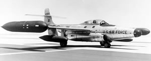


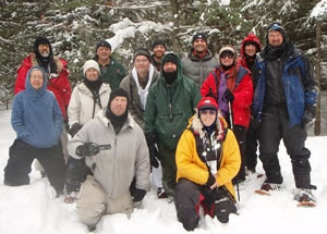
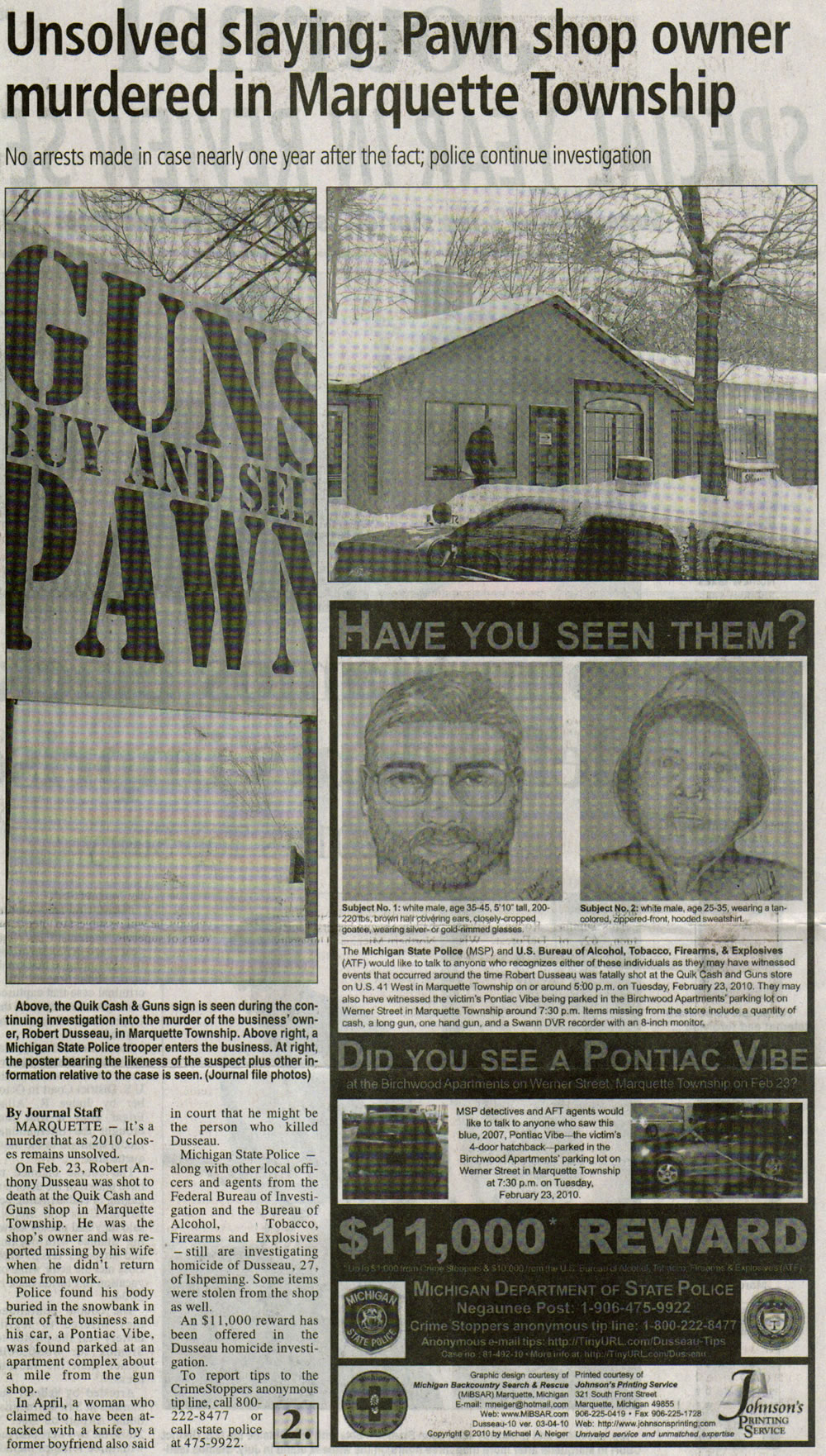
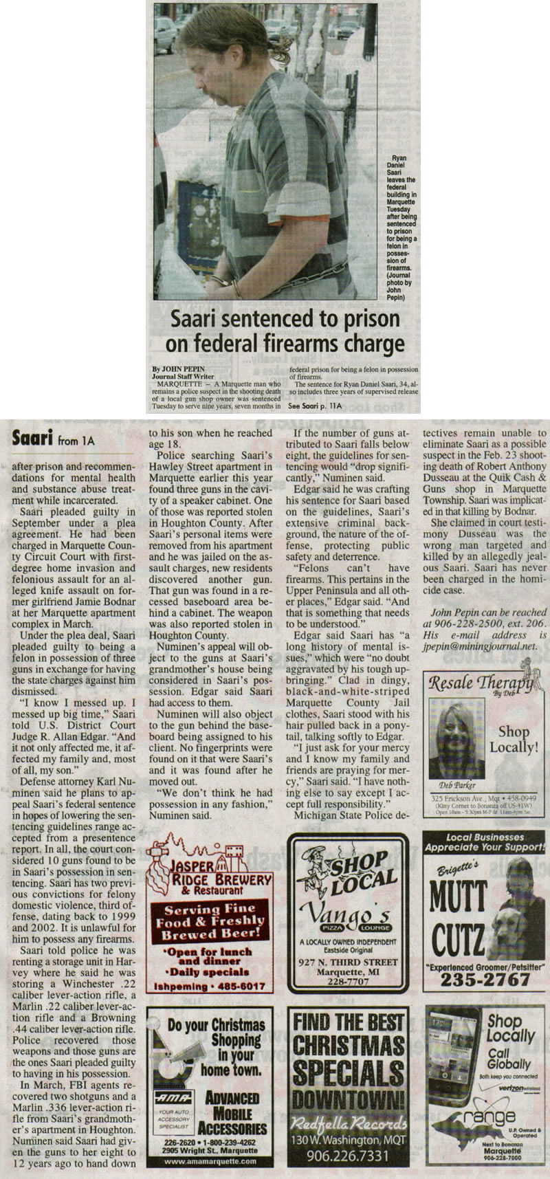

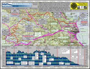
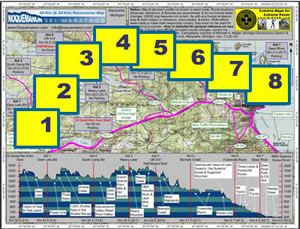


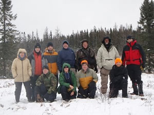


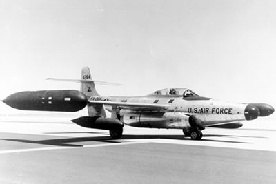


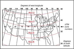
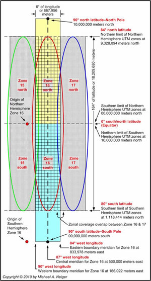
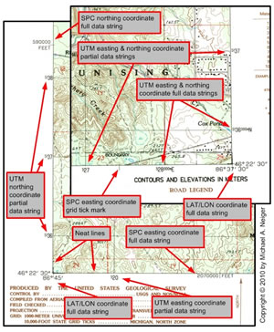
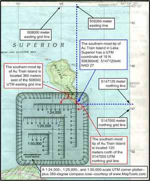


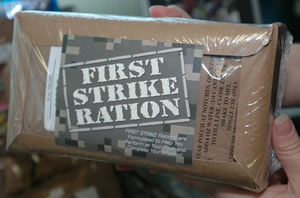
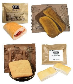


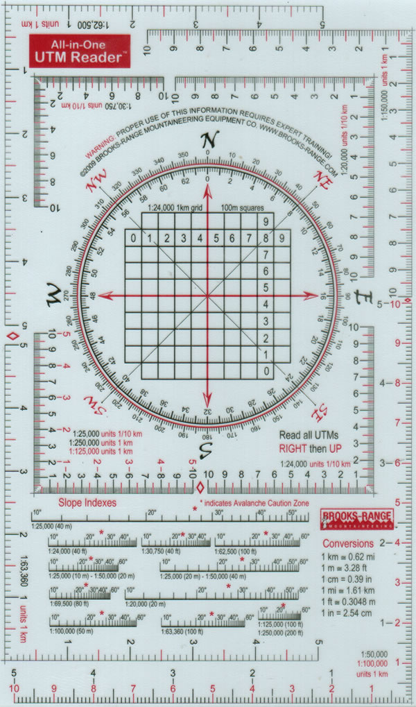
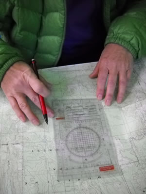
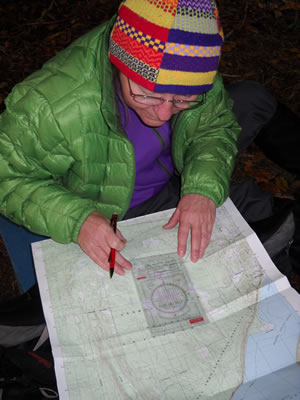


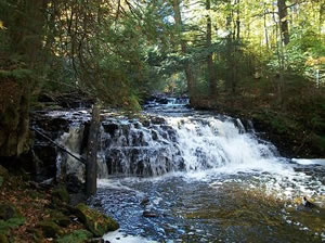


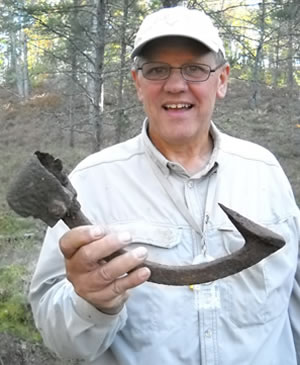
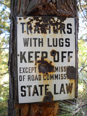

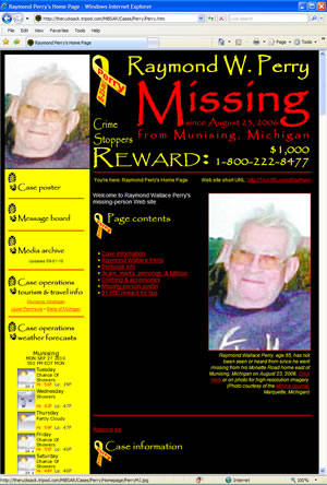


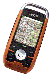

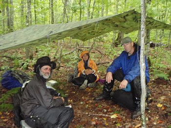
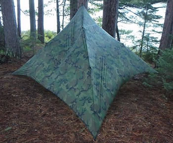
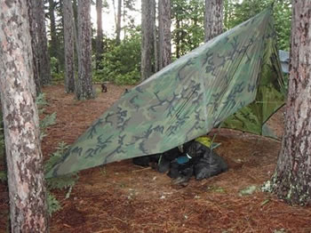
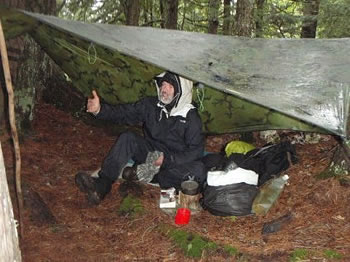
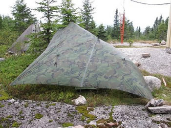


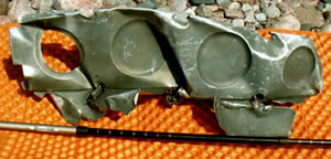


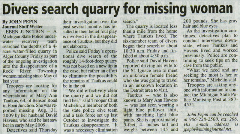


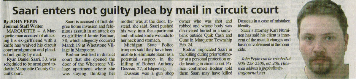


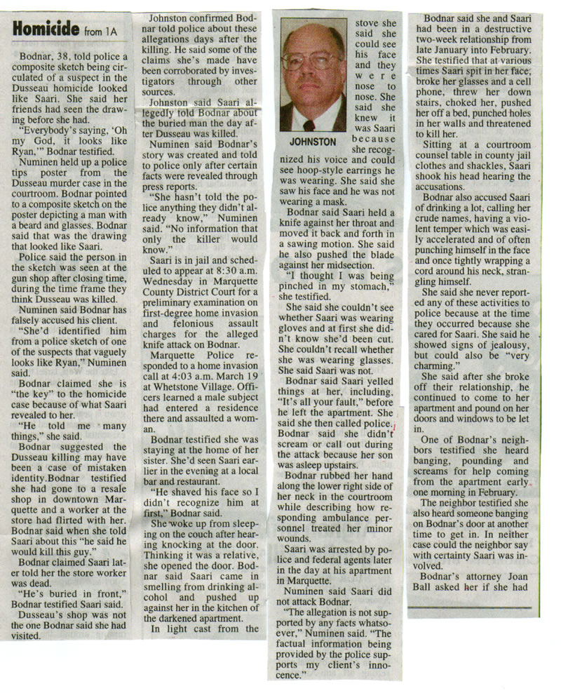
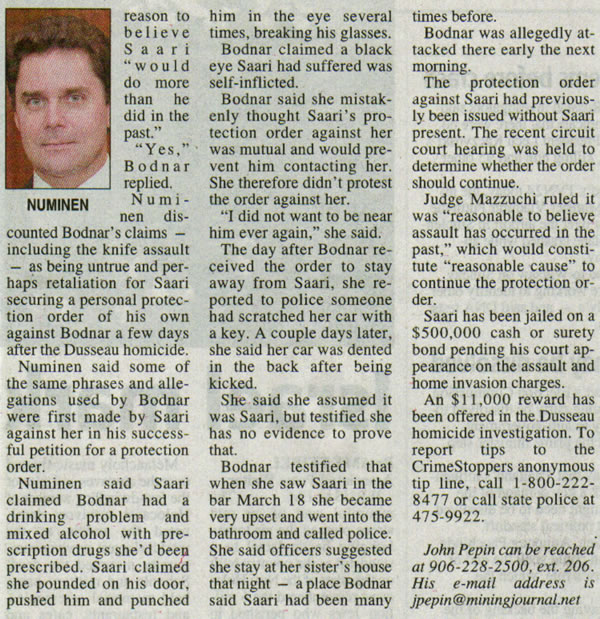
Return to top of page :: Return to home page
In God's wilderness
lies the hope of the world,
the great, fresh, unblighted,
unredeemed wilderness.
— John Muir 1838-1914
Alaska Wilderness, 1890
If
you've been able to read this Web page...
thank a Teacher;
If you've been able to read this Web page in English...
thank a Veteran.
—Author
unknown
•
Copyright Notice •
Content Copyright
© 1984 --
2011-03-20
by Michael A. Neiger
• All rights reserved •
No part of this Web page or this Web site protected by copyright law may be reproduced, transmitted, or used in any form--including graphic, electronic, Web, mechanical or other form--or by any means--including photocopying, recording, taping, Internet distribution, information storage retrieval system, or by other means--for any purpose, except by a reviewer, who may quote brief passages, without the prior, express, written permission of the author.
Comments? Suggestions?
Dead links? Inaccurate info?
Contact the WebMaster,
Michael A. Neiger,
at mneiger@hotmail.com
Web site URL: https://therucksack.tripod.com/MiBSAR/MiBSAR.htm
Return to top of page :: Return to home page
You're here: MiBSAR's home page :: Special Operations Blog :: 2010 archives