| Start point: |
Km 50.0 (0.0)—Al Quaal Recreation
Area, 1,461 feet |
| End point: |
Km 44.4 (5.6)—Aid Station
No. 1, Deer Lake Road, 1,427 feet |
| Length: |
5.6 km |
|
Elevation Data
|
| Ascending: |
+355 feet |
| Descending: |
-389 feet |
| Change: |
-34 feet |
| Minimum: |
1,332 feet |
| Maximum: |
1,552 feet |
|
Description
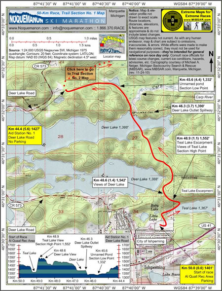
 The
start line at Km 50.0 (0.0, 1,461 feet) is located
at the Al
Quaal Recreation Area in Ishpeming, Michigan.
Parking is available. The
start line at Km 50.0 (0.0, 1,461 feet) is located
at the Al
Quaal Recreation Area in Ishpeming, Michigan.
Parking is available.
From the start line,
racers will ski down to Teal Lake at Km 49.2 (0.8,
1,367 feet) before making a very steep ascent of nearly
200 feet into the Al Quaal hills.
Once atop the Teal Lake Escarpment at
Km 48.9 (1.1, 1,552 feet)--the section's highest elevation
point--racers will be rewarded with a nice view of
Teal Lake.
Even though they've
only skied about 1,100 meters, racers will have already
skied through small portions of three political jurisdictions:
the start line is in the City of Ishpeming, Teal Lake
is in the City of Negaunee, and the current vantage
point is in Ishpeming Township.
As they reach the opposite side of the
ridge at Km 48.6 (1.4, 1,542 feet) Deer Lake will
come into view.
A series of technical downhill sections
challenge racers before they arrive at the shore of
Deer Lake at Km 46.7 (3.3, 1,388 feet). Jagged, granite
bluffs greet racers as they make the 500-meter ice
crossing. Racers leave the lake at the Deer Lake Outlet
Spillway at Km 46.3 (3.7, 1,390 feet). Water exiting
the lake at this point winds it way down to Lake Superior
via the Carp River.
From the spillway, the racecourse winds
its way though gentle pine and balsam forests. The
small, unnamed pond on trail right at Km 45.6 (4.4,
1,332 feet) marks the section's lowest elevation point.
After a gently climb up a draw, racers
arrive at Aid Station No. 1 (Deer Lake Road) at Km
44.4 (5.6, 1,427 feet). This aid station is situated
about 300 meters east of Deer Lake Road. No parking
is available.
Click
here to read about Trail Section No. 2.
|
|
|
|
Click
here or on map above
for high-resolution,
1:24,000-based, USGS imagery of Trail Section No.
1
|
Notice:
The maps and elevation profile charts
are not drawn to exact scale. Route locations,
distances, elevations, features, statistics,
and descriptions are approximate, and do not
include the latest changes or reroutes. USGS
base map features are not current. As with any
human endeavor, this map and chart are subject
to omissions, inaccuracies, and errors. While
efforts were made to make them reasonably correct,
they must not be used for navigational purposes—they
are intended for general reference on race day
only. Consult race officials for the
latest course changes and reroutes as well as
current ice conditions, hazards, advisories,
etc.
Web page design, hosting,
& cartography courtesy of Michael A. Neiger
of Michigan Backcountry Search and Rescue (MiBSAR),
www.MiBSAR.com,
in Marquette, Michigan.

Michael welcomes your
comments and suggestions on how to improve the
maps, charts, and information on this Web page
at mneiger@hotmail.com.
|
|