|
As we drove north to the rendezvous location for another
wilderness journey, I wondered if Mother Nature would have
any major surprises for us or if this would be a comfortable
trip.
So far the summer had been pretty moderate compared to the
extreme heat of last year. My husband, Dan Soper, was driving.
This would be his first off-trail trip since boot camp and
I was hoping he would find it challenging but not overwhelming.
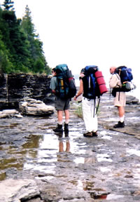
The designated pre-trip bivouac was the boat launch at First
Lake, one of a chain of small lakes formed by the Potagannissing
River Dam, which created a wetland in the midst of Drummond
Island.
Besides trip leader Michael Neiger, our company would include
Gail Staisil of Midland and Charlie Robertson of Grand Rapids.
Gail is a frequent participant in Michael's trips while Charlie,
like Dan, will be a new addition to the group.
That's a good combination because it's fun to catch up on
what friends have been doing and interesting to meet new people
and hear about their experiences.
Dan and I had left home early, planning to take our time
and wanting to be able to stop and look around at any places
of interest. We did pause for coffee and gas at West Branch
and we had a leisurely lunch of burgers with a bit of fudge
for dessert at Mackinaw City.
Near the Les Cheneaux Islands the rocky beach lured us out
for a walk. There was also some delay in waiting for the ferry
to the island. Still we arrived at the planned bivouac in
the late afternoon.
Having had enough driving for one day we decided to set up
camp and settle in for the evening rather than explore the
island further by car. We picked a grassy spot in the shade
and set up our tarps. As it was too early for dinner we decided
to explore a bit on foot.
Along the lakeshore we found some candidates for the "World's
Largest Cattail Award." First Lake looked more like "First
Marsh"--very shallow with a little open water surrounded
by a variety of reeds and water lilies.
At the west end water ran over a rather decrepit looking
dam and down the rocky channel of the Potagannissing River.
I wished for my canoe: the lake would have made a pleasant
afternoon paddle.
Around 5:30 p.m. we decided to cook dinner. Dan made his
first meal on the Esbit stove while I conserved fuel by building
a fire in my hobo stove to cook a package of ramen with some
fresh vegetables from the garden.
After dinner we wandered down the road and out onto a small
logging road. There in the mud were the clear tracks of a
large ungulate. Could there be moose on this Island? The same
tracks were all around our encampment but we had not seen
any moose droppings....
On the way back to camp we encountered Michael driving up
the road to see if anyone had arrived for this trip yet.
He didn't settle in though, as he wanted to check out the
posting (or lack of it) on some private land in order to finalize
our route. He was doubtful about the possibility of moose:
he said it seemed like the last time he camped here there
were cows nearby.
That didn't sound very exciting--I liked the moose idea better.
Michael drove off to recon the route and very shortly thereafter
Gail arrived. We showed her the moose-shaped tracks and she
said her sister had asked her if we were expecting to see
moose on this trip as a book she had about the island listed
moose among the fauna. Two votes for moose...
Gail planned to sleep in her car. We talked a bit and after
awhile Michael returned and set up for the night. We fell
asleep to the hum of mosquitoes and the singing of frogs around
the lake.
The next morning we were rudely awakened by a loud bawling
from the field by the river. The sound came closer. Getting
up to look I saw a herd of cows in the field and four or five
more scattered about in the woods. No moose...just cows....
We made a light breakfast and Gail distributed her home-baked
Power Bars, her traditional contribution to our usual oversupply
of trail snacks. Composed primarily of fruit, oatmeal and
chocolate, these bars can withstand summer's heat as well
as being smashed into unrecognizable shapes and still taste
great.
As we concluded the meal Charlie arrived making the group
complete. It was immediately apparent that he had his act
together: no cotton, reasonable-weight pack, equipment on
lanyards etc.
This trip was off to an auspicious start!
We stowed our gear and set off to spot our cars so that we
had a number of options for ending the hike depending on how
the trip unfolded.
We got enticing glimpses of Maxton Plains in the process.
That area consists of large flat areas of bedrock, which look
almost like pavement when exposed. Most of the plain is covered
by a thin layer of soil which supports a unique alvar landscape--sparse
mixed forest and intervening grasslands sprinkled with wildflowers,
lichens and a number of rare plants that grow only in the
poorly drained alkaline soil.
We saw deer, eagles and sandhill cranes as we drove. Dark
clouds rolled in and a brief intense shower ensued. We returned
to the trailhead and found Dan attending the packs clad in
his rain gear.
Some of the others put on rain gear too, but I decided it
was too warm for that: it would be OK if my shorts and shirt
got wet.
The sky was clearing, but water still dripped heavily from
the foliage as we started along the snowmobile/ATV trail.
The smell of wet weeds was strong and sweet. We walked along
in high spirits chatting and getting acquainted.
At the first break all rain gear was stowed.
As we sat on scattered boulders a small amphibian emerged
from the wet grass near my feet. Less than three inches long
he was international orange with small red spots on his sides.
Apparently unafraid of us, he allowed himself to be picked
up and continued his search for food along the back of my
hand.
When I later looked him up in an Audubon field guide I found
he was a red eft, an immature form of the red spotted newt.
He was most likely looking for springtails, being capable
of eating up to 2000 of them in a day.
We saw a number of these efts in the course of the trip,
as well as numerous small frogs of various kinds.
Keeping close track of our progress across the map, Michael
soon determined that it was time to leave the trail and bushwhack
over to Third Lake and camp on a point near an old hunting
cabin he had found on a previous trip.
This leg of the journey went well at first, but soon we were
hunting for hummocks and roots to keep our feet out of the
water. Seemed like it took a long time to find solid ground
again but when we checked our watches it had only been about
an hour.
We decided to push on to the point near the cabin since it
was a nice spot to camp and access to water was easy. We followed
an old logging road awhile, finding some dilapidated equipment
that was apparently being used in a current logging operation
as there were some new excavations and clear cutting.
After a short break Charlie volunteered to do the azimuth
cutting that would take us to the cabin.
Climbing a bit we skirted a ridge and soon came upon the
cabin. It appeared to be mainly used for hunting and was well
maintained. We picked out camping spots nearby. Gazing across
the lake Michael mentioned that that was the way we would
be going in the morning....
Saturday morning was overcast but warm--perfect weather for
a lake crossing.
After breakfast we wrapped our packs in tarps and rain covers
and stripped to swimming garb and water shoes. We tied our
sleeping pads up to make improvised PFD's (personal floatation
devices).
Looking across the 300 meters or so of lake we planned to
swim, there was a strip of open water in the middle edged
on both sides by pickerel weed, water lilies, rushes and cattails.
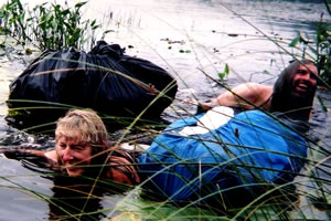
Gail Staisil,
Michael Neiger,
and the rest of
the crew
finally finish
fording
Drummond Island's
weed-choked
Third Lake.
(Photo by Mary Powell)
View Gail Staisil's
Photo
album from this trip
View Dan Soper's
Photo
album from this trip
A brief recon into the water the evening before had determined
that the bottom was fairly firm but covered in loonshit (decaying
vegetation). This was going to be messy.
When everyone was ready we started out. Wading in, our legs
disappeared in the dark soupy material and we moved slowly
avoiding submerged logs and roots.
By the time we were waist deep the drag of the weeds was
considerable and swimming seemed the better option. Floating
alongside our packs and improvised PFD's we began to paddle.
When we cleared the margin of weeds and moved into open water
progress became easier. That didn't last long though: from
the middle of the lake to the rushes and cattails lining the
far shore, there was a floating mass of aquatic plants with
tons of trapped, decaying debris.
We swam around the initial masses we encountered then tackled
the solid mat. We found we could push it down and get on top.
Once there, the most efficient locomotion was a semi-crawl,
semi-swim pushing the packs ahead. It was like trying to cross
a giant bowl of spaghetti.
Once on the far side of the floating stuff we were back in
the weeds and water lilies. A final hundred meters and we
climbed out on an old dock where we poured water over ourselves
to rinse off most of the debris. We dried off a bit, unwrapped
our packs and were ready to hike.
Since Lake Huron lay to the east, we started off on a 90
degree azimuth, which took us to a ridge that we contoured
around before heading east again.
We traversed a couple of klicks (kilometers) of low woodland
and eventually emerged from the woods onto the rocky shore
of Lake Huron's North Channel where we had lunch and studied
the map.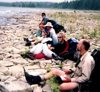
Charlie Robertson,
Dan Soper,
Gail Staisil,
and Michael Neiger
enjoy lunch
along the
North Channel
of Lake Huron.
(Photo by Mary Powell)
View Gail Staisil's
Photo
Album from this trip
View Dan Soper's
Photo
album from this trip
As we were very near the boundary of state land we decided
to camp nearby rather than push on to get past a long stretch
of private property.
Since it was early afternoon there was plenty of time to
relax. We set up our shelters in the woods just off the beach.
Then we went for a swim.
The lake water was refreshingly chilly and removed the last
vestiges of "eau de swamp" from the morning swim.
We lounged on the beach, read and talked. I looked up some
wildflowers I'd seen earlier then baked some cinnamon rolls
on the hobo stove. They turned out rather mediocre--the baking
system needs some fine tuning. Dinner was good though.
Afterward I walked down the shore to Sand Point alternately
taking in the sunset and enjoying the potpourri of flotsam,
jetsam and natural objects that are always spread on a beach.
Besides the usual bits of worn beach glass, interesting rocks,
pieces of board and chain, this evening's display included
a gull's nest with olive speckled eggs, a bright blue plastic
55 gallon drum partly buried in the sand, and a very weathered
picnic table wedged behind a large boulder.
It was dark when I got back to camp and definitely time to
sleep.
The next morning, Sunday, we hiked north along the coast,
across rocks of varying sizes interspersed with stretches
of sand.
Near Colton Bay we encountered a grouchy islander. Though
his offspring were running the beach with ATV's he clearly
did not like our passing by in the water. Assuring him we
intended no harm to his property we quickly moved on.
A couple of coves farther along we settled along a log like
a flock of gulls to eat our lunch.
The shoreline was beginning to turn into long shelves of
flat rock that were easier to walk on than the cobblestone
beaches. In the area known as The Ledges these shelves became
almost continuous with some stretches tilting down into the
water while others were a few feet above it with waves breaking
along their edges.
Though still composed mostly of limestone, these low cliffs
were darker in color and we began to see more fossil rock.
Quite a few snakes were sunning themselves among the rocks.
The snakes included a number of garter snakes as well as a
larger one that had orange, black and white stripes.
Near Reynold's Bay we picked a place to camp. Michael and
Gail swam off the rocky ledges.
After putting up our shelters we built backrests of the many
loose stones and had a comfortable dinner overlooking the
water. Dark clouds piled up above the lake and moved toward
us.
As we were packing up our pots and stoves, the clouds let
loose and we made a hasty retreat to our shelters. Lightning
flashed brightly, thunder crashed and rain poured down for
almost an hour.
At dusk the rain abated. We emerged briefly into the still-dripping
landscape and quickly hung our food. Charlie moved his tent
to higher ground. Then another shower sent us in for the night.
We awoke on Monday to a landscape softened by fog, its sharp
edges obscured, its colors muted...
The black rocks of the shoreline were glistening wet and
there were puddles in every depression.
We gathered for breakfast in the little circle of chairs
built the night before. There was a lot of talk about what
had gotten damp and what we'd managed to keep dry.
As we ate, gulls and terns glided by in search of fish in
the shallow water along the ledges.
By the time we began to gather our things the sun was visible
as a bright disk beyond the drifting cover of fog. We packed
our gear and dissembled our chairs, leaving the beach as we'd
found it.
For a long way the shore consisted of the crumbling ledges
of limestone which were easy to walk on. Increasingly the
ledges and loose rocks contained the fossilized remains of
various prehistoric aquatic creatures.
Stone replicas of spiral shells, cones and discs, and branches
of coral were everywhere. Still imbedded in the ledges were
more fossils--broken white and gray shapes in the darker stone,
vestiges of things that lived an incomprehensibly long time
ago.
Thinking on this made me feel very small--a mote in the total
scheme of things, a passing phase... What signs would our
people leave for those who walk on future beaches?
The rocks were interesting for another reason too: they were
covered with lichens of many colors: bright orange, lime green,
black, sage and others.
Having been intrigued by them on last summer's trip to this
island, I'd brought a book hoping to identify some of them.
The first thing I discovered on opening the book, however,
was that you need a magnifying glass to ID lichens...
The only kind that readily fit the textbook picture was the
orange one that seemed to be "xanthoria elegans"
or elegant lichen. I did learn though, that most lichens are
slow growing, taking hundreds of years to cover a rock of
any size. We were admiring a very old palette of colors...
They are also good indicators of air quality because they
are very sensitive to acid rain and pollutants.
As we moved farther north and west along the coast the ledges
gave way again to cobblestone beaches and stretches of gravelly
sand.
From the time we started walking along the shore we had been
intermittently seeing scat that was composed almost entirely
of crayfish skeletons.
It was cylindrical and about 3/4 of an inch in diameter.
Definitely not gulls' and there was too much of it, it seemed,
for it to be from raccoons who visit but don't live on the
beach.
This morning we caught sight of three moving shapes headed
for the water some distance down the beach. They were black,
their bodies were slender and they moved with an undulating
sinuous grace. Otters! They paused at the water's edge to
look briefly in our direction then disappeared into the waves.
It was Charlie who connected them to the ubiquitous droppings.
As we walked the fog dissipated and the clouds thinned.
By noon the sun was shining brightly. We came upon a stretch
of public land that consisted, in part, of a sandy beach.
We decided to camp there.
Our shelters went up in the woods and our stuff that was
damp from the storm was soon spread out in the sun.
A couple of ATV's passed by and then "neighbors"
came over to see what we were up to. A friendly young couple,
they chatted awhile and offered us the resources of their
cabin: did we need some cold pop or to use their dryer?
Feeling somewhat decadent already, lying around comfortably
in the sun, we thanked them but declined. When they returned
home we had the beach to ourselves for the rest of the afternoon.
We swam, of course, and explored.
A little way down the shore a couple of small streams dropped
from a low ledge onto the beach supporting a profusion of
greenery and flowers.
Inland was a once large lake that had shrunk to a wetland.
Beyond the beach was more cobble rock that stretched to the
next point.
We relaxed, read, ate, and talked till darkness fell.
Over breakfast the next morning we decided that part of our
mission for the day would be to look up Marker 5 on the neighboring
point.
The location of major survey markers is noted on topo maps
and we'd looked up Marker 4 along our route earlier in the
trip. It proved to be a cement pillar about four feet high
with a small clearing around it.
Would Marker 5 be the same? Turned out it wasn't: Gail found
that the brass plate denoting Marker 5 was cemented into a
large boulder on the beach.
We saw a third survey marker on the last day of the trip
too. A Chippewa County one, it was a brass plate on a low
cement pad with a picturesque arrangement of wildflowers around
it.
We ambled along the shore knowing that we didn't have much
ground to cover.
Michael and Charlie explored a two-track while the rest of
us stuck with the beach. Eventually we found each other again...
We approached Grand Marais Lake wondering if it would be
necessary to float the packs and swim from point to point
as it appeared we would on the map.
When we arrived, however, the low water levels in the Great
Lakes had reduced the fording to a wading.
Exploring in the woods nearby we found we found an old aluminum
boat and a set of decoys far from where any water had been
for a long time.
We selected the nameless point west of Grand Marais Lake
for our last bivouac of the trip.
There would be only a short walk to Charlie's car in the
morning.
Charlie, Dan and I pitched our shelters near the tip of the
point for the breeze and the unobstructed view of the sunset
and the night sky. Michael and Gail found a neat clearing
among some deer-cropped cedars and set up there.
We had hours and energy left.
There was a small island offshore and some of us decided
to go there just because it was there. After a somewhat laborious
wade on slippery rocks in waist deep water we received a rather
unfriendly greeting from the gulls who clearly felt we were
in their territory.
Returning to the mainland we swam off the rocky ledges there
to get cleaned up.
I decided to explore the area inland from camp. Old beaches
had been replaced by grassy prairie with old cedars showing
where the shoreline had once been.
Wildflowers were sprinkled among the grasses: harebells,
potentilla, St. John's wort, death camus, daisies and others.
Ponds of stagnant water were populated with frogs and salamanders.
They were likely the intended prey of the several snakes that
disappeared into the grass as I approached.
Finally tired of exploring I returned to camp and found preparations
being made for dinner. The sun was low in the west and the
breeze was turning cool.
We enjoyed a peaceful meal and sat on the beach to watch
the sunset. When there was only a glow left in the sky and
the mosquitoes became a nuisance we retired to our sleeping
places.
I lay in my bug bivy intending to watch the sky fill with
stars. I did see a few but fell asleep long before the sky
was full.
The next morning we packed our things and walked the short
stretch of shore around Chippewa and Hay points before crossing
a marshy cove to Charlie's car.
We loaded our gear and drove off to retrieve the cars we'd
spotted to give us options. At Maxton Plains we took time
to read the informative plaques regarding its unique ecology.
Our little caravan then proceeded to the Bear Track Inn for
a parting meal and another fine wilderness trip was concluded.
View Gail Staisil's
Photo
album from this trip
View Dan Soper's
Photo
album from this trip
Read
another journal...
|