TheRuckSack > photo-journal archive index > archive page
Wilderness Tripping:
Backpacking
Pigeon River State
Forest, Green Timbers Tract, & High Country Pathway
Otsego County
Gaylord, Michigan
December 5-8, 2003
Bushwhacking Through
the Pigeon River State Forest:
Musings of a Ground Pounder
By Jay Hanks
Perry, Michigan
Copyright 2003
E-mail author at WITEWTR58@aol.com
View Gail Staisil's photo album from this trip
View Dennis Waite's photo album from this trip
Return to photo-journal archive index page
Return to TheRuckSack home page
Friday morning
We met out on Font.inalis Road on Friday morning
in a parking area before first light. Light snow and temperatures hovering
around 10 degrees. Mary Powell began stirring after I pulled up and stomped
around, and others crawled out as light slowly crept into the eastern
sky. My Florida-based GPS was having a hard time figuring out where it
was but finally it decided it couldn't be this cold in Florida so it locked
onto the satellites available.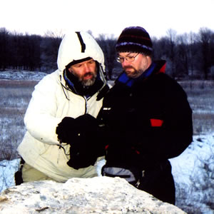
Michael Neiger (Marquette, Mi),
and Jay Hanks (Perry, Mi)
check the coordinates of
a global positioning unit (GPS)
at the western boundary
of the Green Timbers Tract.
(Photo courtesy of Mary Powell)View Gail Staisil's
photo album from this tripView Dennis Waite's
photo album from this trip
We sorted gear one final time and headed off to an intersection with the North Country Trail. Somehow it looked like we were all cross-country skiing in the photo with our trekking poles, but the careful observer will notice the absence of skis. We hiked in the cold, sunny morning and warmed up quickly. Within 35 minutes we were stripping a layer and getting into the rhythm of things.
As we crossed a two-track to rest and change direction, two local firefighters came up in a pickup truck just out sightseeing. We chatted and discussed local terrain. After a few more minutes they turned around since they had pretty much reached the end of the line and we headed off where they couldn't go.
It was quite interesting looking at the topo sheets and comparing them to the ground that we were traversing. We were skirting and crossing some low, swampy areas but in the freezing weather they appeared to be quite walkable. As we rose onto higher and higher mounds of elevation we could see how the land appeared around us. Lunch was consumed at a relatively high point and then we were down into a swale along the Black River.
Surprisingly, there was open water in the marshy areas around the thick vegetation. Either it was seeping in from ground water or the bushes protected the base of the flora from the extremes of temperature. Considering how much work it was for a human to traverse this terrain made me wonder if the wind could be held out as easily? Not reaching an answer to my silent question, we rose up onto another island in the swale.
Plotting an azimuth from there to reach a road intersection began to become quite challenging as the cedars closed in again. I followed some meandering game trails and rivulets of water that appeared to provide a break in the dense foliage. Compensating for the constant sidetracks was a little like guesswork, but trusting the compass was the key. Fifteen degrees deviation to the right must be followed by an equal deviation to the left. I know that if I had left it up to myself I would still be walking in circles.
We broke out of the other side of the swale and soon onto the road of our destination. We swung down to the Black River to gather water for the night and soon were pushing down a ridge into the evening sunlight. We were rewarded at the end of the trail and the gathering darkness with a "walking moon" rising directly in front of us. It made the use of flashlights quite minimal while we set up camp behind the "Atlantic Wall" of the local forester.
The forester had put in successive berms, barriers and obstructions resembling the Normandy Beachhead on D-Day. We had no idea what he was blocking out as the small ridge we were encamped upon quickly dropped back into the swamp, but it gave us hours of conversation and speculation.
Saturday morning
Saturday morning brought overcast skies but no new snow. We reversed our track out of there and proceeded to plot an azimuth to Round Lake. When we popped out of the woods the lake was directly at our feet! Good work on point by Mary! We met up with 3 more trekkers at the lake and took off to intersect the NCT again.
Upon arriving out of the woods near the Pigeon River, we took up the Shingle Mill pathway in the afternoon. This rose and fell along the right side of the Pigeon River and we used the road bridge to cross and continue downstream on the left side. Camp was made along the shore of the Pigeon away from view of the trail and down among the cedars in a quiet spot that actually felt a little warmer.
The moon came up again and shone eerily through the trees. Odd noises on the opposite shore were this evening's topic of conversation without any real conclusions. We shared food and companionship until we slowly drifted off one by one to our sleeping bags.
Sunday morning
Sunday morning was clear and cold (surprise!) and I couldn't wait to start hiking. We regained the Shingle Mill Pathway and summitted Grass Lake Overlook for our first break. It was interesting to see just how much elevation there was around the High Country Pathway. We embarked on a new course from there to a large clearing across the other side of the forest and stepped out into the open sky.
Lunch was made around a tree island in the middle of the large clearing and we all hoped an elk would step out but it didn't. We took a new heading from there to carefully bisect some private inholdings and crossed over one of the forks of the upper Pigeon River. Down a ridgeline and out into the open again. We discovered a beautiful little open area under the trees and began to prepare our dinners as the moon rose once again. We listened all night for the howling of coyotes but only heard them once; a truly lonesome sound.
Monday morning
Finally, on Monday morning we struck camp for the last time and through various courses and directions plotted our return to the vehicles. It was intriguing that as we looked at the topo map and calculated the best path, that a two-track that did not show on the map at all was on the same course. It turned out to take us directly back to our vehicles after we crossed the Sturgeon River, so someone had decided that that was the best way, too. Altogether, I felt both happy and sad to reach the vehicles, knowing that a return to our "normal" lives was close at hand, but new friends and old were parting once again.
______________
View Gail Staisil's photo album from this trip.
View Dennis Waite's photo album from this trip.
Read another photo-journal.
Return to TheRuckSack home page
In God's wilderness lies the
hope of the world,
the great, fresh, unblighted, unredeemed wilderness.
— John Muir 1838-1914, Alaska Wilderness, 1890
Content Copyright © 1984-2004 by Michael A. Neiger
All rights reserved. Comments? Suggestions?
Dead links? Inaccurate info?
Contact the WebMaster at mneiger@hotmail.com
A MacroMedia DreamWeaver 4 and Fireworks 4 production