TheRuckSack > photo-journal archive index > archive page
Wilderness Tripping:
Backpacking & Spelunking
Pictured Rocks
National Lakeshore
Alger County
Munising, Michigan
October 2-6, 2003
ON AND OFF THE TRAIL
AT PICTURED ROCKS--
An October Backpacking Trip
By Mary Powell
Flint, Michigan
Copyright 2003
E-mail author at powell_mm@hotmail.com
View Gail Staisil's photo album from this trip
Return to photo-journal archive index page
Return to TheRuckSack home page
Wednesday--An Evening of Contrasts
This story begins at the Brownstone Inn on M-28 west of Munising where a pre trip rendezvous was planned. My carpool partner, MaryAnn Hayman and I met another trip participant, Gail Staisil, and a friend from previous trips, Sue Schenk-Drobny. Sue's husband, Jim, also joined us. We spent a couple of pleasant hours consuming good food (the Laughing Whitefish Salad is excellent) and getting acquainted and updated on each other's lives with particular reference to wilderness trips. We agreed that Quetico, the White River and Isle Royale are places that we'd like to see again. Maybe next summer...
When the restaurant showed signs of wanting to close we left the luxury of the inn to deal with a gusty fall wind and intermittent cold showers. Maryann and I were "stealth camping" in a local picnic ground. Though it had rained, sleeted and even snowed a bit earlier, the sky was filled with stars when we got back to our tarps. Moonlight lit the edge of a low lying cloudbank in the south. Whitecaps were still breaking along the beach but the gusty wind softened to a steady breeze. I hoped these were auspicious signs as the official forecast for the weekend was truly dismal, with the best day being "mostly cloudy."
Mary Ann Hayman
(S.S. Marie, Ontario),
Alan Wenker
(White Bear Twp, Minnesota),
Gail Staisil
(Midland, Michigan),
and Mary Powell
(Flint, Michigan)
take a break
inside "Smoke Hole,"
a small,
double-entrance cave
located near
Little Miners Lake.
(Photo courtesy of Gail Staisil)View Gail Staisil's photo album
from this trip
I must have set my shelter over a daddy longlegs nursery - a parade of them in assorted sizes wandered across the page as I jotted some notes for this log. Besides wondering what was attracting them, I wondered how the trip would go, how our group would fit together. We had two new people: Maryann from Ontario and Alan Wenker, from Minnesota. The trip leader, Michael Neiger, Gail and I had hiked together before. I also wondered what new things we'd see in this familiar place. We've visited Pictured Rocks in all seasons and always there's been something of interest: ice caves in March, Hellepodium (a zooplankton) in August, snow covered plains in winter, blueberries hidden under ferns in summer. It's always been good.
Thursday Morning
Winnie the Pooh would call this a blustery day: a gusty NW is driving the waves ashore and tossing the trees about. The sky is again covered with thick gray clouds that give us intermittent brief showers. Michael arrived late last night and settled down in his comfy new van. He has already headed for the Dogpatch restaurant to put the finishing touches on our route plans and to meet Alan. I'm waiting for Maryann to finish stowing her tent and we'll join them. Gail is coming a little later...
Thursday Evening--A Celebration
This day has gone rather well though "Plan A" only lasted 'til about 3PM... After breakfast we obtained camping permits and spotted cars strategically to allow for more than one possible conclusion to the trip since things do not always go according to plan on off trail trips especially in this kind of weather. We started our hike at Sand Point. Following the North Country Trail we climbed the sandstone escarpment and walked along the Superior shoreline.
Out on the lake the horizon line looked choppy and the water was dotted with whitecaps. Michael pointed out the East Channel lighthouse under restoration on Grand Island across the way. He also talked about the bell bouys, some sheltered coves and some ship wrecks he visited via canoe as he was collecting information for a book. As we walked a pair of downy woodpeckers lighted on trees near the trail and searched industriously for insects. The fall rains had thoroughly soaked the thin layer of soil that overlays the rock and we crossed many small rivulets running over the edge of the cliff.
Around 2PM we stopped for lunch, resting in a quiet spot in the woods out of the wind. After the meal we hiked a bit farther on the trail then began a bushwhack toward Amphitheater cave and a campsite beyond it in the buffer zone. Sometime after we resumed hiking it became apparent that the proposed campsite might be farther than we could go before sunset, especially if we spent time at the cave. A rather lengthy diversion from our azimuth necessitated by a swamp may have had something to do with it... We considered several alternatives. We postponed our visit to the cave 'til the next day as we still had to ford the Miner's River and get beyond the Park border to camp legally.
A fast hike down the Miner's Falls trail and a scramble down a slope brought us to the stream somewhat below the falls. Swollen by the recent rains it was about 12 feet across and a little over knee deep. The crossing which we did in sandals was chilly but not difficult. After drying off we did a rather strenuous climb up the steep river gorge and headed east through the woods to an old logging road which we followed in the deepening twilight to a camp near a beaver pond on the Little Miner's River. There we worked together to get set up in the dark.
A warm meal rallied our energy a little and we celebrated Michael's birthday with candles on frosted brownies and a rendition of the traditional song. Shortly thereafter we retired to our shelters and snores soon were heard from several of us.
Friday
We awoke the next morning to steady rain and so relaxed in our bags for a while. Finally, motivated in part by the dropping caffeine level in my blood, I got up, put on some Gore-Tex and retrieved our food bags. By the time we'd finished breakfast, the rain had slowed to an occasional sprinkle. We packed the last of our gear and, lifted our packs and followed the old logging road awhile. Then we followed the Little Miners River till we reached the escarpment where it drops over Amphitheater cave. Like the other streams we'd seen, it was swollen with runoff from the rains and we were anxious to see the falls.
We put on our helmets and climbed down to the cave. As always it was a beautiful sight with the river cascading from the top of the arched opening into a pool in the front of the cave. After taking some pictures we settled among the ferns on one side of the cave for lunch. Clouds slid away and some blue sky appeared. It remained while we reclimbed the escarpment and started a bushwhack to Potato Patch campground.
As we rejoined the shoreline hiking trail there, the winds were picking up and the clouds were moving in again. The cliffs were spectacular with the waves crashing against them. The lake looked very cold--gray-blue instead of the turquoise hue of summer. The stretch of trail from Potato Patch to Mosquito Beach was pleasant hiking. We stopped briefly at each overlook to take in the views. The woods were pretty too-not much fall color in the trees yet, but the abundance of drying seeds and dying ferns made it apparent that summer was over. The only birds left appeared to be crows and woodpeckers, the gulls, the jays and, of course, some raptors. The juncos had returned from the north too-the white V of their tails flashed in the underbrush.
On reaching Mosquito Beach we had to decide whether to stay in the campground or withdraw to the buffer zone. Having set up in the dark the night before, we elected to endure the campground for the luxury of setting up in the daylight. To comply with the rule limiting the number of tents on a site, we combined all our tarps into one communal dwelling. A pleasant dinner ensued while the wind roared through the trees overhead and a few snowflakes fell. We could hear the thundering of waves on the beach too. By the time we were ready to turn in, most of the surrounding campsites were occupied and the "bear box" was overflowing with food bags.
Saturday
The rain during the night
had stopped by morning though the wind still howled in the treetops. Michael
took a slight detour to the beach on the way to the bear box for his food
bag and reported that the waves were REALLY big. After breakfast, with
MaryAnn in the lead, we hiked the trail along the shore from Mosquito
to Chapel Beach, again pausing at most of the overlooks to enjoy the views.
Big dark clouds drifted across the blue sky intermittently sprinkling
us with rain. In the varying light the lake was many colors of blue. The
gusty wind did not let up. We had planned to have lunch under a cave-like
overhang at the west end of Chapel Beach, but it bore 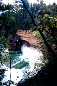 a
strong resemblance to a wind tunnel when we arrived. Instead we continued
to the campground, got set up and had lunch in the shelter of our tarps.
a
strong resemblance to a wind tunnel when we arrived. Instead we continued
to the campground, got set up and had lunch in the shelter of our tarps.
Waves crashing into the cliffs
near battleship row.
(Photo courtesy Mary Powell)View Gail Staisil's photo album from this trip
Michael then said that we had the rest of the afternoon off. MaryAnn and I decided to hike sans the packs further down the shore to Spray Falls. It was an easy and enjoyable couple of hours and we took a number of pictures. Alan elected to read though when we returned we found he'd gone to Plan B and was sound asleep. Michael and Gail decided to explore the south side of Little Chapel Lake and found a lot of old growth trees as well as the remains of a cabin.
Dinner was peaceful, though we suffered somewhat from overabundance of food. We sat awhile and talked by candlelight and finally retired to read.
Sunday
The day started with patches of blue sky and weatherwise improved from there. By afternoon there were only a few small clouds and the temperature was somewhere in the fifties. We began our tour of the chapel area caves by visiting one on an outcrop near Little Chapel Lake. It had the typical structure of sea caves, a half dome-this one still supported by a pillar at the side so that it sort of had two entrances. After taking a few pictures, a short bushwhack returned us to the trail that encircles Chapel Lake. We followed it past the overlook to the lake and Michael led us to a place where it's possible to drop over the ledge and walk along the sandstone escarpment about two hundred feet above the lake.
Lake Superior was at this level many thousands of years ago and eroded a series of sea caves there. We worked our way down the rock wall examining each cave in turn. We talked about how much fun it would be to camp in one of the larger ones if that were legal. In the last large one of the series we had lunch. It was dubbed Raptor cave by Michael when he first discovered it because it had a ledge up high with a large nest of sticks on it. We found this ledge had caved off since our last visit. After lunch we followed the trail around the lake to the Chapel Falls viewing area where we took a short break to enjoythe falls.
Just like hardcore
Sierra Club wilderness trippers,
CUP Group mice also like
spelunking in "Down and Out,"
a littoral-type,
double-entrance sandstone cave
located deep in Chapel Basin,
some two miles back in the bush
from Lake Superior.
Note lack of climbing helmet
and survival gear,
a clear violation
of Sierra Club national policy.
(Photo by Mary Powell)View Gail Staisil's photo album from this trip
Michael then said we had a bit of work to do as our intended campsite was on Spray Creek and it was already after 4PM. He peered carefully at his map, picked a rough azimuth and we began a bushwhack to an old logging road he'd found on another trip. We found it without any problem, a little more overgrown than he'd left it but still usable. What followed was a flawless bit of route finding. Studying the map, checking bearings, counting pace and keeping an eye on the terrain, Michael led us through a maze of overgrown roads to Spray Creek. At the creek there was still enough light to see where to dip our water. A couple hundred meters beyond it at our campsite we had to break out headlamps to set up. The group was rather quiet at dinner--tired or perhaps sorry to see the trip ending. The apple crisp for dessert disappeared completely though.
Monday-The Final Day
It's surprising how late the sun comes up at this time of year: it was still quite dusky at 8AM when we got up. After breakfast we followed the overgrown road on which we'd camped a little farther east and then headed north to the shoreline hiking trail. The sun shone brightly, the trail was easy walking and the conversation was light. When we'd collected our cars we decided to try something different from the Dogpatch for our parting meal and we went to Sharkey's instead. The food there was good but the waitress definitely lacked the sunny disposition of the one at the Dogpatch. We talked about the highlights of this trip. And, of course, about next time...
View Gail Staisil's photo album from this trip.
Read another photo-journal.
Return to TheRuckSack home page
In God's
wilderness lies the hope of the world,
the great, fresh, unblighted, unredeemed wilderness.
— John Muir 1838-1914, Alaska Wilderness, 1890
Content
Copyright © 1984-2003 by Michael A. Neiger
All rights reserved.
Comments? Suggestions? Dead links? Inaccurate info?
Contact the WebMaster at mneiger@hotmail.com
A MacroMedia DreamWeaver 4 and Fireworks 4 production