TheRuckSack > photo-journal archive index > archive page
Wilderness Tripping:
18th Annual (Spring) Canadian Backpacking
Expedition
Agawa Canyon &
Austin Lake Mountain & Firetower
Algoma District
Wawa, Ontario, Canada
May 22-30, 2004
Austin Lake Mountain
& Fire Tower Expedition
An early spring Agawa Canyon
backpacking trip up the Blackspruce River,
overland to Austin Lake Mountain & Fire Tower,
and down Eleven Mile River Valley
By Mary Powell
Flint, Michigan
Copyright 2004
E-mail author at powell_mm@hotmail.com
View Mary Powell's photo album from this trip
View Gail Staisil's photo album no. 1 from this trip
View Gail Staisil's photo album no. 2 from this trip
View Gail Staisil's journal from this trip
View three moose sheds found on this trip
Return to photo-journal archive index page
Return to TheRuckSack home page
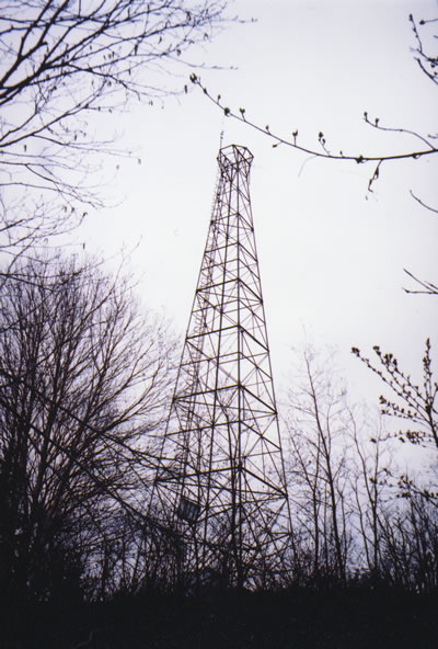
The 200-foot-high
Austin Lake Fire Tower
atop Austin Lake Mountain.
(Photo courtesy of Mary Powell)View Powell's photo album
View Staisil's photo album no. 1
View Staisil's photo album no. 2
View 3 moose sheds found on this trip
Saturday
Assembly
and departure
Our group assembled for breakfast around eight on Saturday morning at the Voyageur Inn and Cookhouse on the east side of Highway 17 in Batchawana Bay. We ordered the usual assortment of pancakes, potatoes and eggs. Michael had a larger-than-usual stack of maps and was studiously reviewing them. This was an ambitious trip: we planned to traverse an entire 1:50,000 topo and climb Mt. Baldy on its northern edge. Just moving forward with nine days of food in our packs would be an accomplishment.
After eating we paid our trip fees and signed away our next of kin's legal right to any compensation should we fail to return from the woods... That done, we got into our cars and drove to the first hurdle--Frater Road. This seasonal byway is prone to washouts in the spring so travelers can never be entirely sure of being able to reach Frater Station...or of being able to return to the highway for that matter. The road was in better than usual shape this spring though, and even my Neon made it to the tracks with a minimum of bumps and bottom scraping.
We are not alone
At the "station," which is actually just an open space containing a few ancient buildings no longer associated with the railroad, we made final adjustments to our packs and double checked that our vehicles were secured. There were five of us in all: trip leader, Michael Neiger of Marquette, Gail Staisil of Midland, Chris Ozminski of Attica, Mary Ann Hayman of Soo, Ontario and myself. We had a bit of a wait for the train, even if it was on time and it often wasn't.
As we waited, the usual assortment of back country travelers assembled: fishermen with coolers of beer, camp owners with tanks of propane and cartons of supplies, paddlers with their canoes. We struck up conversations with several of them. Lee, who worked for the MNR in the Soo was going canoeing. There was a possibility he would like to try snowshoeing and camping with us next winter. Soo, Ontario is not a small town, but Mary Ann must know most of its residents: she and Lee shared a number of acquaintances. Another group we talked with owned the camp near the trail we planned to start on. They welcomed us to use it but had little idea of how far it went.
At the trailhead
The sky had been overcast since early morning and now a light rain began to fall. The train came almost on time. We lifted our packs into the open boxcar and climbed in with them. The conductor was expecting us and had our tickets in order. We rode to 122 1/2 watching the familiar scenery from the open doors. Just south of the bridge over the Agawa the train slowed to a halt with much screeching of brakes and we were dropped at the side of the tracks with our gear.
The day's hiking got off to an auspicious start. We paused as we came to the three falls we had seen before on Black Spruce creek along which we were hiking. A little farther up the river, the trail faded and we had to search for obscure signs for a while. The trail then became more apparent and we were able to make quite a bit of progress. Two creeks and a swamp later though, it disappeared completely (or we made a turn and it didn't). We bushwhacked on for awhile and about the time that ANY campsite would have looked good amidst the thick brush, Chris found a rather nice one around some birches not far from the river.
The sky brightened briefly, but then a slow and steady rain began and kept us under our tarps most of the evening. Also under the tarps, unfortunately, were a fair number of raspberry canes with their many thorns. This clearing must be a regular meal stop for wildlife later in the summer though, as there were a lot of small currant or gooseberry bushes too.
Sunday
A day of decision
Sunday we awoke to a bright but still overcast sky. We bushwhacked over to the river where Chris fished for a bit while we explored the rocky bank and got some pictures. The woods were cool and dripping with water. Wildflowers that had weeks ago finished blooming in lower Michigan were just getting started here.
Trout lilies and spring beauty were almost everywhere. Blue bead lilies, trilliums and star flowers were up, but not in bloom. The deciduous trees had the beginnings of leaves and some of the bushes were in bloom giving the understory a light airy look.
We followed a couple more leads hoping to come upon the lost trail again, but were unsuccessful. Plan A, going to Mt. Baldy depended upon there being some kind of trail most of the way as continuous bushwhacking is much too time and energy consuming. Michael decided we would check out an old road that showed on the map on the far side of the hills along the river.
We crossed through a saddle, climbed another hill and found the two track right where the map showed it to be. Though largely overgrown, it greatly facilitated our travel. We had lunch in a gravel pit overlooking a sizeable beaver pond, which I explored a little. Through the afternoon we followed the old road which was more apparent in some stretches than others.
When it was time to look for a place to camp, we were approaching March Lake as well as the end of the road according to the map. A small gravel pit along its shore proved to be a fine place to stay. Our shelters were very close together in the small space and we joked a bit about rope hazards and zoning restrictions.
During dinner I could definitely smell the pancakes Chris was making for the next day. We checked to see if the road really ended just beyond the lake and found that it did. Careful study of the maps did not turn up any likely path to Mt Baldy. Michael decided it was time for Plan B. About four kilometers away one of his old maps showed Austin Lake fire tower which was rumored to be still standing. It was a worthy objective for our travels.
Monday
A definite low point
Monday morning there was a bit of wind and a steady rain was falling. I grilled my bagel over the hobo stove and the warmth it gave felt very good. We put on our Gore-Tex and packed slowly. By the time we were ready to go the rain had stopped but the sky remained gray and the bush was very wet. We worked an azimuth through a saddle to a small lake and along its shore.
Chris fished through lunch. Michael was distant and Gail very quiet. There was little enthusiasm as we got back on the trail and even when Mary Ann found a moose shed it didn't spark the usual excitement though we, of course, got pictures. The lake that our after lunch azimuth took us to turned out to be an abandoned beaver pond with a small stream running through it. We refilled our bottles and scraped up enough energy to get us to the fire tower that was now barely visible in the distance.
More bushwhacking brought us to the hill and we were approaching on one of the steeper sides. The brush was thick and this part of the hill was actually a series of ledges stacked above each other. Following an azimuth was not really possible so we settled for just going up any way we could. Michael was soon way out in front. By the time we came out on top he was clanging on the metal of the tower to give us the direction.
And then a high one
There were only low bushes and grass on the top of the hill which rose well above the surrounding ones so the view was awesome even without climbing on the tower. The sky cleared some and we watched the sunset over dinner before the clouds came back. All around us stretched forested hills with a myriad lakes in the valleys between. Above us rose the tower which vibrated and sang in the wind. Despite its size it looked frail in the expanse of rugged hills.
We staked our tarps firmly against the wind which was strong and steady most of the evening. Until we tried it we thought doing bear hangs on the tower would be easy. Our efforts were pretty comical though as the ropes refused to slide on some of the metal and the bags hung at odd angles from the slanted structures. Finally the wind died and we settled down to sleep. Some reported seeing the moon between the clouds in the night, but I don't think I opened my eyes till morning.
Tuesday
A spectacular morning
A little after 5AM I ducked out of my tarp intending to visit the bushes nearby. The sunrise was absolutely beautiful: glowing crimson bands between dark clouds. I never made it back to my bag; just stood and watched it evolve. Chris was up watching too and the others soon appeared. We soaked up the view from the hill all through breakfast then gathered our things to leave.
Michael had planned a lake-to-lake kind of day. For starters Chris was going to bushwhack down to a lake that was kind of in the direction we intended to go later. He'd spend the morning fishing there. The rest of us were going to go down to Austin Lake, after which the tower was named. We wanted to see if we could find the keeper's cabin. Then we'd rejoin Chris.
Some interesting finds
Chris departed cheerfully and we started down the hill. It was much easier going down the back than coming up the other side. Austin Lake was long and narrow. Michael theorized that the rangers would have been supplied by plane and that the cabin, if one existed would be along the shore nearest the tower. We worked our way down the shore looking for any sign of habitation and it wasn't long before we came upon a very old dump.
Michael went right to work and had soon excavated quite a collection of antique bottles and cans. A few were familiar--a Vernor's can and Heinz ketchup bottles, for instance. But we also found numerous more exotic containers that once held margarine (complete with directions for mixing in the yellow color), ham, tobacco etc. Raising our eyes finally from the dump, we found other signs of former human occupation, a dock site and a graded pathway that were very overgrown.
There were remnants of a building, which apparently had burned. In the woods nearby were kitchen utensils, a wood stove, bed frame, and other furniture fragments. And on the next rise were the remains of an outhouse and woodshed. We spent the better part of the morning exploring and picturing life as it may have been there.
Return to the fisherman
When we'd had our fill of poking around in the cabin area we headed to the next lake over where Chris was fishing. We found him without any problem, patiently fishing along the shore though he'd not had a bite all morning. It was past lunch time so we took time for that before moving on. In the afternoon we bushwhacked over a hill and across a creek to another nameless lake where we found a rocky point on which to camp and from which to fish.
Now we thought we were close together two nights back in the gravel pit, but that was nothing compared to our settlement on this point. Flat spaces are at a premium in the Canadian bush. We were really used to the rain by this time and the successes of making it to the fire tower and of finding the cabin had raised our spirits a bit. So despite intermittent showers we spent a pleasant evening there.
A beaver came and went across the lake, slapping its tail occasionally to let us know we were in its territory. There were tiny warblers in the trees and they would sing loudly very close by. There were a couple of gulls on the lake too, looking very pristine and healthy unlike those we see at home in the McDonald's parking lot. I tried fishing along with Chris, but neither of us had any luck.
Wednesday
A beautiful bog
I awoke early Wednesday to the sound of rain on my tarp again. Went back to sleep for a while but the picture didn't improve much: it was still sprinkling when I woke up again. I stuffed my damp sleeping bag and made coffee. That improved things quite a bit. The sky remained overcast, but the rain finally stopped.
We hiked with Gail leading to nearby Roderic Lake where we found a really neat bog. Walking out on the mat of floating vegetation to get water I spotted a number of pitcher plants and as I dipped my bottle I saw a salamander, a large leech and a couple of small fish. We decided to pause here for lunch to fish and explore.
Michael spotted something shiny in the trees on the far side of the bog and after lunch I went over to investigate. It was a plastic tarp possibly from a winter fishing camp, but I couldn't get to it because there was an apparently bottomless stream between the edge of the bog and the bluff the camp was on. I stuck an evergreen snag more than ten feet down into the loon shit without meeting any resistance. It made me very glad that I checked before stepping onto the apparent bottom of the stream: though by this time the sun was shining, it was much too chilly for swimming!
Time to rest
After lunch we bushwhacked on to Joki lake which proved to be very nice. The water level was low and several old beaver lodges were exposed. We were able to walk along the shore on the rocks. About halfway down the lake at a narrows, we found a high rocky bluff open on top--an ideal campsite. We spent the afternoon drying damp stuff, bathing and sunbathing, fishing and reading. It was a wonderful break.
Near dinner time an eagle sailed by and the half moon was out in the clear sky. At bed time it was still clear and the frogs were singing loudly. I decided to sleep out on a small ledge at the bottom of the bluff near the lake. The stars were beautiful over the lake but directly over me were four of the largest white pines I've ever seen. We'd been commenting that we 'd not seen any cut stumps for the last day or more: it looked like this area had never been logged.
Thursday
Lost in the woods
Sunrise the next morning was beautiful--pale cream to gold and then to peach color. The few clouds that were highlighted by it though soon grew to fill the sky. It was chilly: there were ice crystals in our water bottles. By the time we finished breakfast the rain had begun again. It was my turn to lead and I promptly got us lost in more ways than one.
We were following what seemed like a straightforward course, traversing some lowlands headed for the next lake. When we came up on a slight rise in the midst of the thick stuff we paused to look at the water glinting through the trees ahead and Chris said, "You know, I haven't seen Michael in a while." Gail said, "He goes off to look at things sometimes--he'll be back."
We went on slowly another hundred meters or so and Mary Ann caught up with us and said, "I might have heard a whistle back there a ways..." Gail said, "You know, I might have heard that too, but I thought it was a bird." The steady drizzle and our rain gear definitely muffled other sounds.
I mentioned to Chris that I was concerned that the terrain wasn't matching up with the map quite right: we should have come to a creek before the lake we were seeing ahead... So we stood together in the rain, peering into the forest and listening intently, like a flock of ducklings whose mother had gone off without them. After a few minutes I called Michael's name and Chris followed suit, amplifying it quite a bit with his louder voice.
From far in the distance, and not from the direction we'd come, came a faint reply. After a few more shouts to home in on, Michael appeared hurrying through the thick brush. "Are you all together? What are you doing here?" he asked. He said he'd been paralleling us along the top of a ridge and suddenly we were gone. When he got down from the ridge there were several little valleys we could have gone into and he started shouting, whistling, and checking each one to no avail.
We had not heard any of his calls or whistles for certain. It was a sobering reminder of how quickly you can get separated in the bush. He had had trouble tracking us since the ground was very wet. We decided to consult the GPS on the issue of the map not matching the terrain and it told us that we were considerably south of where we intended to be. Rather than backtrack, we went to Plan B for the day, picking another lake as our intermediate destination.
Lunch in the rain
Michael took over the lead and after another kilometer or so of pushing aside vegetation (I was developing a real animosity toward tag alders), we came out on the sandy shore of the lake he'd chosen. It was lunch time but a steady rain was still falling. Checking out a beaver channel that led back from the shore, Michael found a small clearing where they'd felled some birches.
We decided to put up a couple of tarps to be out of the rain while we ate. Warm drinks sounded good too, so we gathered sodden twigs for fires in the hobo stoves. We gathered quite a bit of bark from the fallen birches too and it proved to be the more effective fuel. Keeping the fires burning and the water heating and eating kept us occupied for almost two hours.
What goes up must come down
Though it was mid afternoon, Michael decided that we'd try to cover a little more ground. We set out to Mobout Lake. We planned to go around to the outlet and follow that stream to the next lake and camp there. The swamp was thick to the lake and following Mobout creek looked even worse as it was in a rocky valley choked with fallen trees. We decided to go over the neighboring hill to our goal.
Going up was nice despite the climb. The brush thinned out to mixed forest and briefly to hardwoods. We congratulated our selves on having made things a bit easier. Then we reached the top and looked at going down. We found we could get down to the creek, but passage to the lake was cut off by rocky walls. We could ford the stream in the cold and rain and maybe be able to get down stream on the far side or we could go up again and find a way down the cliffs.
We decided on the latter hoping to make it before dark. We climbed up moving downstream at the same time. Near the top we let Michael do a bit of scouting though we had serious reservations about letting him out of sight again. :) He found a narrow ledge (Picture about 18 inches wide with an overhang that slanted outward) that led to a lower ledge from which only about a six foot drop was required to reach the valley floor.
He selected a storm-damaged sapling to use as a handrail to make the narrow ledge crossing safer. That accomplished, we lowered our packs off the last ledge before and dropped down one at a time after them. With dusk coming on, we moved downstream and almost immediately found a campsite that made it all worthwhile.
Near the mouth of the creek was a stand of large cedars. The open ground underneath was padded with fallen needles. The stream rushing over rocks made a soothing sound. There was dirt along the shore and an abundance of downed wood with which to build a fire.
We soon had our portable subdivision up, ropes in the trees for bear hangs and a collection of firewood assembled. On the shore close to the water where no trace would be left we built a fire big enough for cooking and for drying of socks. We stayed up a little later, planning to sleep in bit in the morning.
Friday
Finding the road to go home
The next morning a thick fog hung over the lake. We took our time getting ready and Chris tried his hand at fishing again. We hiked another series of lake to lake azimuths with the evenings objective being Saga Lake where the map showed the end of an old logging road. Finding that road would greatly increase the probability of getting back to civilization on schedule. The day was sunny but there was a cold breeze.
Around mid afternoon we found a small waterfall, then a pond and near the pond the remnant of an old skidder road which we followed to Saga Lake where it grew to haul road proportions. We hadn't gone far along the lake when we came to an old gravel pit that provided a pleasant view of it as well as a flat open area to camp.
In the woods nearby Chris found an old canoe gradually being smashed by the trees growing around it. He and Michael pried it from the imprisoning trunks and upon discovering that it had no serious holes, Michael began constructing a paddle from some saplings and a stuff sack. Chris would have a chance to do some serious fishing of this lake.
After about half an hour of cutting and lashing, Chris was ready to go. We got out our cameras in case the voyage didn't last long, but all went well and Chris paddled to several quadrants of the lake in search of the elusive trout. The rest of us were finishing dinner and preparing to watch the sunset when he returned. Saga was a pretty little lake surrounded by rounded hills, eroded remnants of ancient mountains.
Clear and cold again
As darkness fell we moved to our shelters or sleeping spots. I was betting on another clear night and sleeping out to see the night sky. The moon and stars did their usual spectacular show and I caught succeeding acts as I woke up during the night.
Saturday
Frost and ice
In the morning my bag was stiff and sparkly with frost and there was ice in the water bottles again. Our most reliable thermometer said 24 degrees Fahrenheit. The sky was clear and the sun's warmth was not long in coming. By the time we were packed the frost had melted and our gear was nearly dry.
Chris made pancakes for everyone, noting, however, that we should not get too used to the idea because in the future he planned to bring carbs that were less work. He joked that between the fishing and the pancakes he was getting pretty tired. There was no break in sight for him though as Michael pointed out that he would HAVE to try fishing the Agawa when we got there this evening....
On the road again
We started down the logging road which soon showed signs of ATV or snowmobile use, setting a fairly leisurely pace as it was very likely now that the road would continue to our proposed campsite on the river near Bucksaw Bill's place and across from the tracks. It proved to be an interesting hike.
We looked for and found a road we would need on next year's expedition to reach a remote power line and then Mount Baldy. We were now following along the route of a recent Eco Challenge event. With perfect timing for lunch we found a waterfall near the road on Shannon Lake creek. It was a cascade, falling about ninety feet in three steps with a small pool at each level. Mary Ann and Gail elected to stay near the bottom in the sun and wash their hair. Chris went up to the top pool to explore and swim, after eating with us on a shady ledge.
It was very relaxing and a hard place to leave. As the sun climbed through the morning the temperature did too and the thermometer now read in the seventies. Chris commented that this was both our coldest and warmest day. With the warmth came the black flies, of course. We had been seeing a few all along, but on this afternoon they were definitely at nuisance level. It was one of the few times we all got out head nets.
Shortly after the falls, we spotted our first black bear. It was a large one and was apparently traveling down the road in the opposite direction when it spotted us as it rounded a corner. Barely hesitating, it turned and loped away in the direction it had come. We followed the tracks a bit hoping to get a picture, but when it cut into the brush along a wetland we continued on our way.
Farther along we came upon a unique bridge over Eleven Mile Creek. Three huge old growth logs held to the banks by cables formed the supporting structure. Over the logs was a veritable patchwork quilt of different types and ages of wood and boards.
Despite the extensive patching there were a number of places where you could see the river flowing below. Spring floods had displaced one end of the massive structure about five feet down the bank to the limit of the restraining cable. It wouldn't last many more springs.
On the far side we paused momentarily to check out the snow-smashed remains of a small travel trailer probably left by hunters or trappers many years ago. Continuing down the road we were lucky enough to spot another bear, smaller than the last, maybe half grown. This one too took a very cursory look at us then disappeared into the woods.
Trapper's trail
Early in the day Michael had reviewed the implications of the "Y" structure of logging roads, pointing out that the bottom of each Y usually points in the direction of civilization. After a while we came upon another of these Ys and the arm we had come on had a sign designating it the "Bill Olar Trail", in memory of Bucksaw Bill , a trapper and early resident of the Agawa Canyon area. The sign had a rusty trap attached that may have been one of Bill's.
Actually we had seen quite a few marten traps in varying states of repair on this trip. They consist of wooden boxes nailed to trees 3-4 feet from the ground with the trap inside. Martens are carnivores about the size of a domestic cat and have long, soft fur similar to mink. They are extremely curious and easily trapped with such a device. Trapping is highly regulated to prevent their becoming endangered. We later had an opportunity to talk with a registered trapper who lived in the canyon near the tracks.
Maybe next time
Another few klicks down the road we could hear the roaring of a falls we had thought about bushwhacking to, Raindrop Lake Falls. We still had quite a bit of ground to cover though, and decided to save it for another trip. We did get a chance to see it from a distance across the next lake we passed. It was big and appeared to drop over several ledges like the one we'd seen at lunch. At another time it would definitely be worth a couple hundred meters of bushwhacking to see it up close.
Camp on the Agawa
We continued on to the Agawa River where we set up camp in the sandy open area near the pilings of a bridge that spanned it during the logging era. We swam, lay on the sand to dry, explored the area, watched hawks circling overhead and generally relaxed. A cabin owner across the way offered a boat crossing, but we thanked him and stuck to our plan to swim across the river to the tracks in the morning. When it was almost bedtime Chris gave in and got out his fishing pole, but again, no luck.
Sunday
Crossing the river
Next morning dawned cold, but clear, and by 11AM, when we planned to swim, the air was acceptably warm. As there was a rapid in front of our camping place, we moved farther downstream where the river was deeper and narrower. We assembled our PFDs, wrapped our packs, and prepared to cross.
The water was cold but not dangerously so for a swim of the anticipated duration. Michael went first, crossing successfully and shouting back that the current in the middle was pretty strong. Chris and Mary Ann went next and with a bit of work made the other shore. I took a picture as Gail embarked, then followed her. She paddled strongly and also made it.
I don't know what happened to me. Maybe it was the momentary distraction of removing my bug net, maybe it was that I angled too much into the current instead of concentrating on the other shore, or maybe it was the breeze that came up and pushed at my pack...
Whatever the cause, I found myself in the current being carried steadily downstream and making little progress toward my friends. They asked if I needed help. I took a few more strokes before giving in and admitting that I could use some. Chris jumped in immediately and assisted me and my pack to the shore.
Trip's end
Once we were all on land, we dried off and dressed and basked in the sun a while. The owner of the nearby cabin, who was also the trapper mentioned earlier, came over to chat for awhile. He lived in the Soo so, of course, Mary Ann knew his relatives...
We decided that we would walk the half mile down to he next regular stopping place on the tracks rather than flag the train down here. We had a couple hours to wait anyway. At 118 1/2 we sat on the porch of the small wooden waiting area and chatted with the locals waiting there too. Much interesting information can be had that way.
About half an hour after the scheduled time, we heard the wail of a train whistle in the distance. Soon there was the screeching of brakes and the boxcars with their doors open to the nice weather rolled to a stop in front of us. We waited our turn, lifted our gear and climbed in for the ride back to Frater.
Another awesome trip was at an end. The topic of conversation as we rode was "Next time we come back to The Canyon...."
_______________
E-mail author at powell_mm@hotmail.com
View Mary Powell's photo album from this trip
View Gail Staisil's photo album no. 1 from this trip
View Gail Staisil's photo album no. 2 from this trip
View Gail Staisil's journal from this trip
View three moose sheds found on this trip
Read another photo-journal.
Return to TheRuckSack home page
In God's wilderness lies the
hope of the world,
the great, fresh, unblighted, unredeemed wilderness.
— John Muir 1838-1914, Alaska Wilderness, 1890
Content Copyright © 1984-2004 by Michael A. Neiger
All rights reserved. Comments? Suggestions?
Dead links? Inaccurate info?
Contact the WebMaster at mneiger@hotmail.com
A MacroMedia DreamWeaver 4 and Fireworks 4 production