You're here: Backpacker
Magazine :: Forums
:: Destinations
:: Midwest
Forum :: Photo-Journal
Discussion Thread :: Photo-Journal Page
You're here: TheRuckSack
:: Photo-Journal
Index Page :: Photo-Journal Page
A Michigan Bush Rats' Photo-Journal...
Off-trail Backpacking and Wreck Chasing
Porcupine Mountains Wilderness State Park
Silver City :: Ontonagon County
Western Upper Peninsula of Michigan
June 28 to July 4, 2008
7 Days of Backpacking
through Michigan's
Porcupine Mountains Escarpment
in search of abandoned,
135-year-old, silver mines;
copper mines; waterfalls; old growth;
and the seldom-visited
1944 wreck site of a
U.S. Army B-17 Flying Fortress
By Michael A. Neiger (LandNavMan)
Marquette, Michigan
© Copyright 2008E-mail author
View Dennis Waite's photo album from this trip
View trip beta page for this adventure on Backpacker Magazine's Midwest Forum
View additional, Michigan Bush Rats' photo-journals
Learn about free, Michigan Bush Rats' upcoming trips and expeditions
Friday, June 27
Silver City bound
Do to scheduling conflicts, several of the participants who originally planned to participate in this trip were unable to do so at the last minute. In the end, the crew consisted of Dennis Waite of Berrien Springs, Michigan, and myself, Michael Neiger (LandNavMan) of Marquette, Michigan.
After a relatively short, 120-mile drive over from Marquette, I arrived in Silver City, Michigan about 9:00 Friday evening. I spent the night near the mouth of the Big Iron River. With his 600-mile drive, Dennis had laid over in Raco, Michigan, on Thursday night, where he spent some time researching the feasibility of establishing a sled-dog outpost there. On Friday night, he stayed in a rather expensive room at the AmericInn Hotel (1-906-885-5311) in Silver City.
Saturday, June 28
Scranton Silver Mine • Bonanza Falls • Superior Silver
Mine
As planned, we both met in the lobby of the AmericInn for breakfast. When we learned breakfast would not be served because the dining room had been reserved for a wedding, we ended up enjoying an excellent, calorie-laden, omelet-potatoes-and-toast breakfast at The Foothills Restaurant (1-906-885-5246) just down M-107 a bit.
Once fueled for humping our rucks into the seldom-traveled, 1870s-era Silver City Mining District, we visited the Porcupine Mountains Visitor Center. After viewing their informative exhibits and perusing their gift shop, we purchased a three-night backcountry camping permit (the first three nights of our trip were to be spent in the old silver mining district just east of the park proper).
Permits in hand, we spotted my van at the site of the old White Pine Extension Mine along the South Boundary Road. We then drove back to Silver City where, after leaving Dennis' vehicle at the AmericInn, we shouldered our rucks at the point where the old Gaines Logging Road originates on the south side of M-107 along the shore of Lake Superior, between the Little Iron River and Ash Creek.
As we hiked south up Gaines Road—a gated, muddy, practically-overgrown two-track—and into the foothills of the Porcupine Mountains Escarpment, we kept an eye peeled for remnants of the old 1870s-era railroad grade and associated spurs that serviced the area's many silver mines some 135 years ago. We eventually located traces of its main, east-west-running grade, and proceeded to work it eastward to where it cut the Little Iron River.
When we arrived at the Little Iron, we found remnants of where the rail line crossed the river on both banks and the approaches to same. On the west bank, an elevated earthen grade led up to rock-and-dirt abutment at the river's edge.
Upon fording the river, we found a large, eroded pile of locally-collected fieldstone that apparently served as an abutment along the river's east bank; it appeared to be heavily eroded. Inland from this rock abutment, we found the remains of a trestle—several huge, vertically-arranged timbers—that would have supported the elevated line until it reached an earthen grade visible some distance away.
Dennis inspecting the remains of the old trestle. View Dennis Waite's photo album from this trip
While none of the trestle's cross-timbers, wooden ties, or iron rails were found, a close inspection of the river bottom revealed evidence of the old line: a very-long, half-inch-diameter iron spike with a bifaced tip, which would have been used to affix the bracing planks to the upright trestle timbers; and an 18-inch-long, piece of heavy, iron strap with four holes, which would have been used to join two iron rails together, end to end.
Just upstream of the old trestle, Dennis found a heavily-clawed pine tree with clumps of black bear hair stuck in gobs of pitch oozing from the tree.
Black bear hair stuck in gobs of pitch oozing from a pine tree.View Dennis Waite's photo album from this trip
After a relaxing lunch under a couple of huge eastern hemlocks along the river's east bank, we set about searching for any sign of the old, long-abandoned Scranton Mine, known in later years as the old Collins Mine.
The Scranton Mine was a silver mining operation run by the Scranton Silver Mining Company that was organized in 1873. It purchased the mining claim and homestead of Austin Corser, who is credited with originally discovering a silver vein in the area around 1855.
The mine reportedly consisted of a 300-foot-deep vertical shaft located along the east bank of the Little Iron River in the southwest quarter of the northwest quarter of section 13, just north of the old, east-west-running railroad grade.
Unable to locate the mine in this area, we headed eastward towards our next objective: Bonanza Falls on the Big Iron River. However, a couple hundred meters down the old grade we spotted what appeared to be the remains of an old, overgrown rail spur heading south. On a hunch we dropped our rucks and worked this grade a bit south. In short order, we'd discovered two vertical shafts along the east side of the spur. Both were flooded and rimmed by square berms of fractured rock.
Satisfied with locating the remains of the Scranton Mine, we shouldered our rucks and headed east for Bonanza Falls, which has also been called Greenwood Falls. This falls is located in the southeast quarter of the northeast quarter of section 13, along the 130-foot-wide Big Huron River, just downstream of where the old, east-west-running railroad grade we'd been hiking crossed the river. Several decaying concrete support piers remained where the railroad cut the river. While some of the piers remained upright and in-place, massive fragments of some of the others were visible just downstream of their original location.
Old concrete-and-rock piers for the long-abandoned railroad trestle over the Big Iron River, just upstream of Bonanza Falls. View Dennis Waite's photo album from this trip
Our oldest maps indicated a stamp mill—or ore-crushing facility—was at one time located a bit upstream on the opposite bank of the Big Iron River.
Bonanza Falls is a 60-foot-wide falls consisting of two separate drops spaced about 200 yards apart. The upper falls drops about ten feet; the lower about three feet. The soft, layered, river rock is worn and sculpted—some say finished to resemble hand-rubbed pewter—into a number of interesting channels, ledges, potholes and other unique configurations.
Bedrock sculpted through the ages by the Big Iron's current. View Dennis Waite's photo album from this trip
With the water in the eight-foot-deep pool at the base of the falls warmed by the sun-heated bedrock upstream, Dennis and I spent upwards of a half hour swimming and diving around the falls. At intervals, we'd relax in a whirlpool or set on a ledge beneath the falling water.
Dennis cools off in Bonanza Falls on the Big Iron River. View Dennis Waite's photo album from this trip
Once thoroughly refreshed by the falls, we returned to the old railroad grade in search of a spur that would have led south, to the old, long-abandoned Superior Mine. This mine was supposed to be located along the west bank of the Big Iron River, in the northwest quarter of the northeast quarter of section 24, very close to the east-west-running section line.
The Superior was a silver mining operation run by the Ontonagon and Lake Superior Silver Mining Company. Organized in 1873, during the silver boom, this mine was known simply as The Superior. Funded by Marquette capitalists, the company's mine was located on land owned by Charles G. Collins, the eccentric operator of an Ontonagon dry-goods store. The mine consisted of an adit—or horizontal shaft—dug into the hillside, adjacent to the riverbank. An old stamp mill was reportedly located a bit upstream on the opposite bank of the Big Iron River.
We quickly found the old spur but lost it after a few hundred meters. With Dennis on point, as he would be for the remainder of the trip, we headed for the probable area where the mine would be located. After a bit of searching, Dennis called me over to a small, debris-filled vertical shaft. Like the shafts of the Scranton Mine, it was rimmed with fractured rock.
Having located the mine, we hiked upstream along the west bank of the Big Iron River in search of a suitable bivouac spot. After jumping four white-tailed deer about 400 meters upstream, we set up our tarps on slight bench overlooking the rocky Big Iron River.
To cool off after our four-klick (kilometer or 1,000 meters) day of tick-laden bushwhacking, we both swam in the river again—this time in a shallow, narrow channel. As we would for much of the remainder of the trip, we battled no-see-ums and mosquitoes during the evening.


Sunday, June 29
Pewabeck Falls • Ash Creek Trapper's Cabin • Ontonagon
& Lake Superior Silver Mine
It rained hard during the night, but stopped well before we crawled out of our bivy sacks. Denny reported he'd heard a deer snorting during the night.
After breakfast, we donned our rain gear as the foliage was extremely waterlogged. Working point, Dennis cut a 1,000-meter azimuth over to the Little Iron River where we hoped to check out Pewabeck Falls. The falls was supposed to be located in the northeast quarter of the northeast quarter of section 23, very near the section corner, and just upstream of a very tight bend in the river.
As hoped, we emerged from the bush just upstream of the falls. This four-foot drop consisted of a half-dozen chutes arrayed across a rocky ledge that spanned the width of the river.
Pewabeck Falls on the Little Iron River. View Dennis Waite's photo album from this trip
Upon fording the Little Iron, we immediately located a nice bivouac area for a future trip to the falls.
From Pewabeck Falls, we bushwhacked over to the Ash Creek watershed, using a portion of the old Gaines Logging Road, in search of the Ash Creek Trapper's Cabin. Before we could begin our search for the cabin, we stumbled upon what appeared to be the remains of a very old logging camp, one from the days when horses and brute strength were the standard.
LandNavMan inspects part of an old, cast-iron wood stove found at the Ash Creek Logging Camp. View Dennis Waite's photo album from this trip
Located on a bluff overlooking the east bank of Ash Creek, just downstream of the confluence of the main branch with the west branch, we found a coil of heavy cable, chains, pulleys, a large wood stove, assorted cast-iron fixtures, and the two, parallel runners for a horse-drawn sled that was likely used to haul logs over ice roads.
However, our most unusual finds were three, horse-drawn, earth-moving scoops loggers would have used for excavating and filling as they built rugged roads through the bush.
Dennis inspects an old earth-moving scoop and other iron hardware he found at the Ash Creek Logging Camp.
LandNavMan inspects another earth-moving scoop found at the Ash Creek Logging Camp. View Dennis Waite's photo album from this trip
Done with our survey of the area, we worked an old, overgrown road that had been cut into the slope that led down to the main branch of Ash Creek. When we arrived at the point where the road would have crossed the creek, we found the remnants of the camp's cook shack: a large, scattered pile of rusting, institutional-size food cans, many of which appeared to have been hastily opened with a very large kitchen knife.
After fording the main branch of Ash Creek, we climbed an extremely-steep razorback ridge that separated the two branches of the creek. Leading the way along this ridge, which was extremely narrow and precipitous at times, it wasn't long before Dennis spotted the roof of the seldom-visited Ash Creek Trapper's Cabin.
Heavily screened by ferns and dug into the west-facing side of the ridge overlooking Ash Creek Gorge 50 feet below, the cabin was situated in the northeast quarter of the southeast quarter of the southwest quarter of section 23.
Dennis atop the Ash Creek Trapper's Cabin. View Dennis Waite's photo album from this trip
The tiny, one-room cabin did not appear to have been visited in a long time, possibly since the Midwest Forum's Equipage visited it many years ago, as we had to shovel several inches of sand out of the way—and cut through a network of roots—to get the small, 18-by-24-inch door open enough to peek inside.
Dennis crouching down near the entrance to the Ash Creek Trapper's Cabin. View Dennis Waite's photo album from this trip
Once illuminated with a flashlight—the cabin was windowless—we discovered this underground structure was constructed just like a log cabin. All four walls were fashioned from corner-notched logs and the roof, panels of corrugated steel, was supported by log rafters.
Dennis inside the Ash Creek Trapper's Cabin. View Dennis Waite's photo album from this trip
Inside this approximately 6-foot-square, 4-foot-tall, dirt-floor, one-person cabin we found a ripped canvas cot along the south wall, a WWII-era military stove along the back or east wall, and a folding chair along the north wall. An assortment of cooking utensils and pots were arranged around the stove, and miscellaneous items such trap-rigging wire, ammunition, firewood, cans, tools, etc., were scattered about the floor, walls, and at least one small shelf. Two handless shovels were found outside the cabin, near the entrance.
With the cabin explored, we sat down nearby to enjoy our lunches. Before we'd finished our lunch, the light, intermittent rain had given way to sunny skies.
After stuffing our clammy rain suits in our rucks, Dennis set about cutting a 1,600 meter azimuth back to the Big Iron River, where we intended to search for evidence of the old, long-abandoned Ontonagon & Lake Superior Mine. Along the way, we reforded the main branch of Ash Creek, cut Gaine's Road, and reforded the Little Iron River.
Waist- to chest-high ferns were common along portions of our route. View Dennis Waite's photo album from this trip
As we worked our way down the escarpment towards the west bank of the Big Iron, Dennis spotted two, steel leg traps left behind by a trapper along the edge of a beaver pond.
We encountered beaver activity as well as beaver sign when ever we traveled near a river or pond. View Dennis Waite's photo album from this trip courtesy of Dennis Waite)
Once we arrived back at the Big Iron, we immediately began searching for any remains of the Ontonagon & Lake Superior Mine. Operated by the Ontonagon and Lake Superior Mining Company that was founded in 1873, this silver mine was supposed to be located in the northwest quarter of the northeast quarter of section 25.
After a rather exhaustive search in which we found remnants of the old railroad grade that would have serviced the mine, we concluded the mine entrance must have been concealed by a beaver pond that had flooded over a portion of the grade.
Hot and dirty from hiking 5.5 klicks of high-humidity bush, we set up our tarps just back of the riverbank and went for a cool, refreshing swim, the second of the day. Shortly after we finished dinner, a mature bald eagle flew up our side of the river at eye level. What an up-close and personal experience. It was most certainly looking for a trout dinner.


Monday, June 30
Collins Silver Mine • Cleveland
Silver Mine • Nonesuch Falls • Nonesuch Copper Mine • Nonesuch
Ghost Town
It rained and thundered violently much of the night, but by morning it had let up. After a leisurely breakfast, we forded the Big Iron River to search its east bank for two old silver mines: the Collins and the Cleveland.
The old, long-abandoned Collins Mine was supposed to be situated along the east bank of the Big Iron River in the southwest quarter of the northeast quarter of section 25. This silver mine was operated by the Collins Mining Company that was founded in 1875.
After discovering the old railroad grade that likely serviced the Collins Mine, we eventually found a vertical mine shaft in a ravine at the base of ridge, well back from the riverbank. It too was collapsed and filled with debris.
Operated by the Cleveland Silver Mining Company that was founded in 1875, the old, long-abandoned Cleveland Mine was supposed to be located along the east bank of the Big Iron River—south of the Collins Mine—in either the northeast quarter of the southwest quarter of section 25, or in the northeast quarter of section 25.
After a lot of searching, we found what may have marked the mine site: a flooded depression on a plateau above the river. From the Collins Mine site we descended back down to the Big Iron where we hiked upstream, along the river's east bank. When we were pushed into the river proper by a steep, rocky cliff, we forded the river to its opposite bank.
Since it was sunny and hot, we both went for a swim before enjoying lunch under several shade trees that leaned over the riverbank.
With lunch finished, we began exploring an old, overgrown two-track atop the west bank of the river. Lined with pine trees and smooth as the day it was originally graded, we enjoyed it immensely. Before long, we came across what Dennis thought was a Model A Ford. Resting on its roof under a canopy of massive old growth—eastern hemlocks—a rather large paper birch tree emerged from the rusting vehicle.
When the low plateau of old growth ended as the river merged with a huge ridge, we climbed up to the top of ridge. While hiking along the top of the ridge on a seldom-used logging road, we came across dozens of piles of timber wolf scat. This led us to name the very tall ridge Timber Wolf Ridge.
After a few klicks of travel, we descended towards the Little Iron River once again. Just before we forded the Little Iron, we entered into the Porcupine Mountains Wilderness State Park for the first time.
The Michigan DNR on the Porcupine Mountains...
The Porcupine Mountains were dedicated as a Michigan State Park in 1945 to protect the last extensive tract of old-growth hardwood and hemlock forest remaining in the Midwest.
At nearly 60,000 acres, it is Michigan's largest state park, and among the Midwest's largest wilderness areas. Well-worn by the glaciers, to the native Ojibwa people, this chain of mountains rising from the waters of Lake Superior reminded them of kâg, the woodland porcupine. The mountain range they called, Kâg-wadjiw, the Porcupine Mountains.
Fifteen years before the Civil War, miners searched for copper in these mountains, and the landlookers soon followed, cruising the forests for pine and cedar.
Today, visitors are drawn to the Porcupine Mountains for their majestic old-growth forests, striking geologic formations, wildlife, waterfalls and outstanding wilderness opportunities.
Once across the Little Iron River, we began hiking upstream to Nonesuch Falls. Along the way, we were amazed at the unique, highly-eroded and -channelized nature of the riverbed.
Some 600 meters upstream, we began to hear the rumble of Nonesuch Falls. A 12-foot graded drop, Nonesuch Falls is located in the southwest quarter of the southeast quarter of section 1, adjacent to the old Nonesuch Mine ruins as well as a mining ghost town of the same name.
Nonesuch Falls on the Little Iron River, the water of which was discolored with sediment from heavy rain. View Dennis Waite's photo album from this trip
Climbing up the west bank, we soon came upon remnants of the old, long-abandoned Nonesuch Mine. This copper mine was operated by the Nonesuch Mining Company. It was founded in 1866 by a group of men from Ontonagon, Michigan, after Ed Less discovered a vein of copper in the area's sandstone shale in 1865.
The Nonesuch placename originated from the uniqueness of the geology in the bedrock: "none such" rock—copper-containing sandstone—had ever been found before.
The Placenames of the Porcupine Mountains Area, courtesy of the Michigan Department of Natural Resources...
With names like Presque Isle, Lake of the Clouds, Nonesuch, Carp and Iron, the diverse culture, geographic and natural heritage of the Porcupine Mountains had a broad influence on the naming of many places in the park.
The name Porcupine Mountains can be traced to the Native Americans of this region. Kagwadjiw (porcupine mountain) was the name given to the range of hills that resembled a crouched porcupine when viewed from a canoe that plied early trade routes from the Keweenaw Peninsula to the Apostle Islands.
Lake of the Clouds was not always known by this name. Prior to the early 1900s, the lake was known as Carp Lake. Its possible origin could be from the word escarpment that could have been shortened to carp. However, the word carp is not very romantic, intriguing or inviting, so early promoters of tourism in the area began using Lake of the Clouds. The Big and Little Carp rivers as well as Carp Lake Township all kept the original name.
The name Presque Isle is not uncommon in the northern Midwest. Perhaps this name can be traced to the early days of the fur trade era when French traders and voyageurs traveled the lakes and rivers. Presque Isle literally can be interpreted as "almost an island," and it is a fitting name indeed for the park's western most river because of the land formation at its mouth. In spring, or when water levels are high, there are two separate mouths with an "island" in between. At other times, the lower water levels create a single mouth. The "almost island" is created by the river bed and the shallow, lagoon-like body of water.
Miscowawbic is the Ojibwa word for the red metal we call copper. Through the 1800s Michigan was the nation's leading copper-producing state and reached a peak in production in 1916. Following World War II, the White Pine mine continued to drive local economies until it closed in 1994. Nonesuch, Halliwell, Union, White Pine Extension, Carp Lake, Cayahoga, Lone Rock and Layfayette all are named after copper mines once located in the park.
Summit Peak, the highest point in the park, once was considered the highest location in Michigan and thus the "true" summit of the state. But two other peaks, Mt. Arvon and Mt. Curwood, both located east of L'Anse in Baraga County, are slightly higher
In its infancy, the Nonesuch Mine consisted of two, 180-foot-deep shafts located about 250 feet apart. Two more shafts were eventually added, with the fifth level of shaft No. 3 reaching the 460-foot mark. Before it closed for good in 1912, it produced nearly 390,000 pounds of copper. Operated by five different owners, the mine never turned a profit.
While none of the shafts remained intact—they'd all reportedly collapsed—we did find an amazing number of interesting structures in the area.
In the river, we found signs of the old tramway that crossed atop the falls.
Along the west bank of the river, we found several oak-lined vats buried in the ground. These were reportedly used to chemically leach the very fine copper from the sandstone and shale ore in the later years of the mine's operation. We also found rocks ruins—massively-thick foundations and towering walls fashioned from locally-collected fieldstone—of kilns, ovens, mine shops, water-powered and steam-powered stamp mills, a hoist house, etc.
A rock foundation at the site of the old Nonesuch Copper Mine. View Dennis Waite's photo album from this trip
In earlier times, the plateau back of the above rock ruins was the site of a schoolhouse, log cabins, frame homes, boarding house, stores, livery stable, lumber mill, and other assorted buildings. Complete with ditched streets, this area was the flourishing mining town of Nonesuch.
A horse-drawn tram road ran between this tiny settlement and Union Harbor, on Lake Superior, and a stagecoach connected it with other points in the region. From 1876 to 1887, it had its own U.S. Post Office, and by the early 1880s, its population numbered upwards of 300. The mining town even had a baseball team, complete with uniforms.
Not much remains of the Village of Nonesuch today other than crumbling foundations and a scattering of odd boards, logs, tin, mortar, bricks, rocks, nails, fruit trees, flowering bushes, etc.
A kiln at the site of the old Nonesuch Copper Mine. View Dennis Waite's photo album from this trip
Once we had thoroughly explored the ruins of the Nonesuch Mine along the west bank of the Little Iron, we forded the river just above the falls and climbed around the two huge piles of mining rock towering over the river along its east bank.
Since it was getting late, we worked our way upstream, well back from the river. We eventually established our night bivouac along the east bank of the river, high atop the adjacent ridge.
Refreshed after a leisurely swim in the river, we retired to our bivouac site atop the ridge for dinner, hungry from 10-klicks of exploring. Rising overhead was a stand of old growth eastern hemlock, something we'd see more of as we worked our way further into the park's remote, unspoiled backcountry.
The Vegetation of Porcupine Mountains Wilderness State Park, courtesy of the Michigan Department of Natural Resources...
Porcupine Mountains Wilderness State Park is characterized by Precambrian bedrock ridges and almost complete (95%) forest cover.
One of the primary objectives in setting aside the area as a state park was to "preserve forever as a forest museum the largest stand of mixed hardwoods and hemlock existing in Michigan."
Within the park is a block of primary or uncut forest of approximately 35,000 acres in size. This forest constitutes the largest stand of old growth hardwood and of hemlock in the Great Lakes region and is considered by the Michigan Natural Features Inventory to be the "biggest and best tract of virgin Northern Hardwoods in North America."
The principal forest type within the park is a closed-canopy northern mesic forest (Curtis 1959), dominated by sugar maple, eastern hemlock, and yellow birch, with lesser amounts of eastern white pine, red maple, basswood, green ash, northern white cedar, and northern red oak.
Disturbed forests occupy sections of the park that were logged prior to state ownership. Much of the park's Lake Superior shoreline was logged prior to 1914 and was burned by a large slash fire in 1919. This area now supports extensive white birch, quaking aspen and balsam fir forests, and numerous shrubland openings.
Large areas in the eastern part of the park were clearcut between 1930 and the late 1950s. These lands now support mixed hardwood forests.
Pioneer communities characterized by bearberry, blueberry, juniper, and dwarfed pine occur along cliffs and rock outcrops in several areas of the park.
Through state legislation (Sec. 35103 of Part 351,1994 PA 451, Wilderness and Natural Areas), 40,808 acres of Porcupine Mountains Wilderness State Park's nearly 60,000 acres of land area is designated Wilderness.


Tuesday, July 1
Exploring the hills of the Porkies
We awoke to a warm, sunny, breezy day. Dennis reported he'd heard wild turkeys during the night. I must have been sleeping too soundly to hear them.
After breakfast, we forded the Little Iron River just above an old cable walkway—sans tread boards—running across the river. Slightly further downstream, we discovered a single cable strung across the river. A rotten plank seat slung from a pulley on the cable and a thick, sun-bleached retrieval rope allowed one to cross the river in early times. Both apparatuses were likely used by the members of the 40-acre Nonesuch Lodge, which was situated just to the north, along the South Boundary Road.
As we worked our way northward, around the Nonesuch Lodge property and towards the South Boundary Road, we came upon a row of a dozen or so rusting, 55-gallon fuel barrels. A bit farther along, we passed two rusting oil furnaces. We speculated these items may have been castoffs from the nearby lodge in days past.
After a rest break along the South Boundary Road, Dennis cut a rather long azimuth to the summit of Hill 457, where we enjoyed lunch, and heard the attention-getting bleating of a nearby animal—possibly a bear cub. We elected to leave the issue of its origin unresolved. Trees in full foliage denied us a panoramic view of the surrounding wilderness.
Rested and refueled, Dennis cut an azimuth down to a saddle running along the west flank of the hill. From here we climbed to the top of Hill 436. Standing atop its steep, northwest flank, we could see Hill 521 in the distance as well as perhaps a sliver of Lake Superior's Union Bay.
As Dennis lead the way down the eastern slope of Hill 436, we made a very interesting observation: we were passing immediately in front of the entrance to an active, underground bear den. Seeing freshly-harvested vegetation just inside the entrance, and a well-packed trail of recent bear tracks down-slope of it, we hustled to distance ourselves the den.
Clear of the bear den and in search of our night's bivouac, we explored the headwaters of the Little Union River, which consisted of a number of small beaver ponds sandwiched between Hills 436 and 521.
With six klicks of travel behind us, we ended up bivouacking on a beautiful, pine-needle-laden knoll dotted with monstrous eastern hemlocks. Located at the base of Hill 521, it overlooked the uppermost pond on the Little Union River. We both cooled off in the upper pond before Dennis checked the ponds for brook trout. Unsuccessful, he and I settled in for a cup of tea and dinner.
During our time near the pond, we jumped two white-tailed deer, found a three-foot-long snakeskin, watched a duck and its young move about the pond, and listened to the occasional slap of a beaver's tail on the water.
Ringed with wetlands, the chain of ponds erupted in a tremendous chorus of peeps and croaks after dark. Ending what had been near silence when we climbed in our bivouac sacks, the cacophonous commotion woke us both up suddenly. Soon afterward, heavy rain pounded down on our tarps. When violent thunderstorms passed through the area, we began to consider whether we should assume the squatting position on our foam pads.
Wednesday, July 2
Trap Falls
Despite the night of heavy rain, we awoke to clearing skies. Breakfast complete, Dennis contoured us west around the base of Hill 521 until we were at Lost Creek. Once abreast of the creek, we headed upstream, intent on seeing the Lost Creek Yurt that ChicagoLand Ron and Company had visited this past winter. We located the vacant yurt along the east bank of the creek, about 800 meters upstream of where the tumbling creek cuts the South Boundary Road.
Dennis at the Lost Creek Yurt. View Dennis Waite's photo album from this trip
The inside of the yurt, which looked very clean and orderly, was well lit by generously-large windows. A nice deck attached to the yurt overlooked Lost Creek Gorge below. A large, knee-high fire ring was situated on the opposite side of the yurt.
According to park literature, there are three, four-season yurts available for rent. User Information for dead-of-the-winter visitors to the Lost Creek Yurt carries the following, cautionary note:
Winter travel to the Lost Creek yurt requires physical stamina, specialized equipment, and expert way-finding and winter survival skills. Due to deep snow and steep hills, only expert backcountry skiers and snowshoers should attempt to travel to the Lost Creek Yurt. For safety reasons, and to share the strenuous work of breaking trail in deep snow, always travel in a group.
The bunks inside a Porkies'yurt. (Photo courtesy of the Michigan DNR)
The 16-foot-diameter yurts are equipped with bunks and mattresses to sleep four. Heated with a stout wood stove—a cache of wood is supplied—each yurt is also provisioned with an axe and bow saw, eating utensils, and cookware. An outhouse is located nearby.
A Porkies yurt in the winter. (Photo courtesy of the Michigan DNR)
After working the foothills around the base of Hill 521 to get to this yurt, and studying our quad, we began to appreciate the effort Ron expended on his arduous, dead-of-the-winter journey to this yurt, the remotest and most difficult to reach of the park's three yurts. Nice job Ron! And Jerry (jjo on the Midwest Forum), you might want to check these yurts out, if you've not done so already, as Ron is on to something real neat here.
With thoughts of bringing his sled dog team into the Porkies to work the yurt system on his mind, I almost had to grab Dennis and point him towards the Lost Creek Gorge and its trail, lest the day slip away before we had time to reach our planned bivouac at Trap Falls. The falls is located along the main branch of the upper reaches of the Carp River, which is known as the Carp River Inlet.
After nearly four-and-a-half days of bushwhacking, it was a pleasant experience to trek up the wide-open Lost Creek Trail, past the Lost Lake campsite amid its towering eastern hemlocks, and then down Government Peak Trail to Trap Falls.
Dennis fishing for trout at Lower Trap Falls on the Carp River Inlet. View Dennis Waite's photo album from this trip
Finding no trout in the fish'n-and-swim'n hole below Lower Trap Falls, Dennis took us upstream to a point where we forded the Carp River. He showed me where an old Adirondack-type shelter had been located in past years.
The shelter long-since removed, he worked us up the east bank of the river until we came to a truly-awesome bivouac site immediately adjacent to Upper Trap Falls. Carpeted by a soft bed of pine needles and screened from the sun by gigantic eastern hemlocks towering overhead, this was one of our best evenings of the trip.
Upper Trap Falls on the Carp River Inlet. View Dennis Waite's photo album from this trip


Thursday, July 3
Government Peak • 1944 wreck
of U.S. Army B-17 Flying Fortress
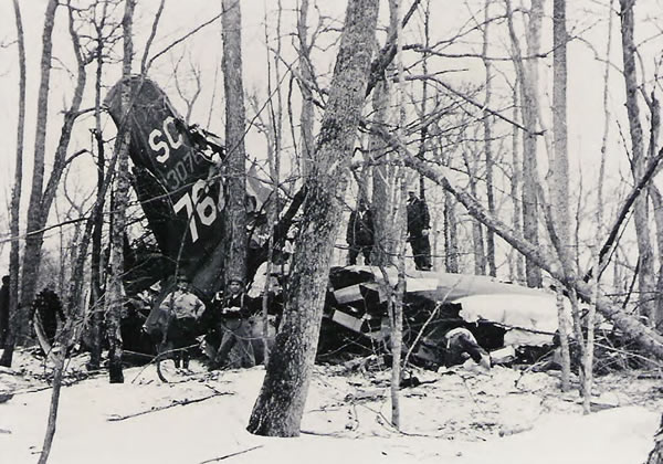
Up bright and early for the highlight of our trip—an attempt to find the remote, 1944 wreckage of a WWII U.S. Army B-17, commonly referred to as a Flying Fortress due in part to its 13, fifty-caliber Browning machine guns—we watched the Carp River tumble down the rocky gorge in front as we ate breakfast and enjoyed some caffeine.
The tail section and fuselage of the U.S. Army B-17 Flying Fortress that crashed into a rugged mountainside in the Porcupine Mountains bush, south of Hill 541, in 1944. (Army Corps of Engineers April 1944 crash site photo courtesy of Jeff Benya)
Our stomachs full, we reforded the Carp River Inlet between the upper and lower falls, and hiked north on the Government Peak Trail for what would be our most-physically-challenging and navigationally-technical day of the trip. Looking at the quads, we figured we'd be trekking some 10.5 klicks before we could begin our search for any sign of the plane that had crashed some 64 years ago.
A couple kilometers after we passed the trail's junction with the Lost Creek Trail, Dennis' sharp eyes on point spotted a black bear—one he estimated at under 150 pounds—moving along the trail and up the escarpment ahead of us. We followed it for a while, but it eventually climbed a rocky face, an apparent shortcut to the summit of the 1850-foot-high Government Peak.
Once we'd climbed to the peak proper, we checked out the two fire rings, a nice campsite, and the foundations of the old Government Peak Fire Tower. While we figured we'd run into the bear on the peak, we never did cross paths with it again, even while quietly eating lunch near the remains of the fire tower.
After lunch, we searched long and hard for the brass benchmark that usually marks such high points. Eventually, we found the remains of it: a concrete-filled, cast-iron pipe buried securely in the bedrock that is common thoroughout much of the Porcupine Mountains. However, the hand-stamped, brass plate that should have been affixed to the top of the permanent marker was nowhere to be found. Seeing the shattered, rusting edges of the quarter-inch-wall pipe, we figured it may have been forcibly removed, looted by a thoughtless, rogue ground-pounder many moons ago.
Geology of the Porcupine Mountains, courtesy of the Michigan Department of Natural Resources...
The bedrock of the Porcupine Mountains records part of the evolution of the North American continent during the late Precambrian Era.
Rock strata within the mountains belong to the Keweenawan Supergroup, a thick sequence of volcanic and sedimentary rocks (exceeding 25 km) deposited about 1.1 billion years ago, during and shortly after an episode of continental rifting.
This Midcontinental rift system represents the early stages of continental breakup and is a major geologic feature of the North American Continent. Outside of the Lake Superior region, most of the Midcontinental rift is concealed by younger rock strata. In the Porcupine Mountains, the rocks that filled the rift and post-rift basin are well exposed along the park's Lake Superior shoreline, rocky river beds, and numerous ridges and escarpments.
The oldest rocks outcropping in the Porcupine Mountains are the massive andesite and rhyolite flows visible throughout much of the park's interior uplands and easily visible at the Summit Peak Scenic Area. These rocks, known as the Porcupine Volcanics, lie atop older continental flood basalts of the Portage Lake Lava Series.
The Porcupine Volcanics were deposited by a large stratovolcano just south and east of the mountains. This form of volcanism is unique in the rift system, which was dominated by flood basalts issuing from long fissures along the rift axis.
Overlying the Porcupine Volcanics is a sequence of fluvial (river deposited) sedimentary rock known as the Copper Harbor Conglomerate. The deposition of these rocks marks the end of rift extension and the beginning of sedimentation in the post-rift basin.
Conglomerates of the Copper Harbor formation contain clasts derived primarily from Keweenawan Supergroup volcanic rocks.
A series of thin basalt flows marks a brief return to volcanism during Copper Harbor deposition. These flows, called the Lakeshore Traps, form one of the park's most prominent geologic features; the extended basalt-capped escarpment overlooking the Lake of the Clouds.
Lying atop the Copper Harbor sediment is the Nonesuch Shale. This body of black to gray shales and siltstones was deposited in a relatively shallow body of water occupying the post-rift basin or valley.
The youngest exposed rock in the mountains are the red sandstones and siltstones of the Freda Sandstone. Exceeding 3 km thick beneath Lake Superior, these rocks mark a return to fluvial sedimentation in the post-rift basin.
The Presque Isle river flows across the tilted edges of the Nonesuch and Freda formations at the Presque Isle Scenic Area, providing excellent exposures of both rocks.
Following rift extension and post-rift sedimentation, continental compression, attributed to the Grenville Orogeny, produced major thrust faults and folding of Keweenawan strata. As a result of this deformation, the Porcupine Mountains anticline, Presque Isle syncline and Iron River syncline—all features that can be observed in the park—were formed.
The Keweenawan rocks are notable for significant copper deposits. Secondary mineralization by copper, epidote, quartz, prehnite, and pumpellyite fill voids, fissures and vesicles in basalt flows.
Utilization of the region's copper deposits was begun by prehistoric peoples active in the region long before European arrival. Historic extraction of the copper resource began in 1845, when the region witnessed the nation's first mining rush.
The Pleistocene glaciation has left abundant evidence in the Porcupine Mountains. Lake Superior, relic lake shorelines, erosion of the bedrock comprising the mountains, and extensive ground moraine deposits are reminders of the region's glacial heritage.
The last advance of the Wisconsin Glacial-the Greatlakean-deployed ice in the Porcupine Mountains region about 12,000 years ago, retreating about 9,000 years ago. As the ice sheet melted, water impounded between the ice front and adjacent uplands produced a sequence of proglacial lakes.
Although these lakes were relatively short lived, they left signature shorelines along the north flank of the Mountains. Carved step-like into the side of the mountains, these old beaches are among the park's most prominent glacial features.
Before we descended from the summit of Government Peak, we spent some more time taking in the distant views from the sheer, northwest face of the peak. Standing on this overlook of bedrock, we could clearly see Lake Superior beyond Cloud Peak and Cuyahoga Peak. Lake of the Clouds was obscured from view by Hill 407 and Hill 425.
Confident we'd taken in all the peak had to offer us, Dennis led us down the southwestern slope of Government Peak to a point where the Trail cut the headwaters of the Carp River Inlet. From here, he began what would be our longest and most complicated bushwhack of our seven-day trip: a 12-leg, 4,800-meter-long route to the B-17's probably location—a rugged, thickly-forested hillside about 550 meters south of Hill 541.
Before we cut into the bush, we topped off our water stores as they would have to hold us until dinner. At the midpoint of our afternoon of bushwhacking we took a break atop Hill 521, which afforded us a gorgeous view to the south and east. It offered us a clear view of Hill 522 and Hill 507, two, seldom-visited rocky outcrops we hoped to recon on a future trip.
After a bit of rehydrating and snacking, Dennis worked us down the southwest-facing slope of Hill 521.
As he meticulously cut each of the 12 azimuths required to get us close to the wreckage south of Hill 541, my job was to keep close tabs on the distance we'd traveled on each leg of our route by tallying a pace count with a set of Ranger pacing beads attached to the shoulder strap of my ruck. Each time he'd covered another 100 meters of bush, I'd update him. From time to time, he'd pause, orient his map to north, and carefully compare and contrast the terrain features confronting him with those that were represented on his 1:24,000 quad.
To pull off this rather complicated, 4,800-meter-long, off-trail route, Dennis had carefully preplotted each leg of our route using his topographic map, baseplate compass, and metric distance scale: he'd calculate the azimuth to an objective, measure the distance in meters, and note the upcoming terrain features.
As the afternoon progressed according to plan, we eventually crossed the uppermost reaches of the Little Iron River. By dinnertime, Dennis had us within striking distance of the probable location of the Hill 541 wreck site.
Since it was getting late, we hurriedly established our night bivouac on a park-like, hemlock-studded knoll overlooking a small pond beneath Hill 541. Once we'd secured our food from roving black bears—I hung mine while Dennis secured his Ursack bear sack to a tree trunk—we set off to recon the rugged hillside of Hill 541 for any sign of the wreck.
Some 20 minutes later, and about 30 meters above and 400 meters west of our bivouac site, we both nearly simultaneously tripped over fragmentary pieces of the B-17's fuselage that were hidden under the thick carpet of leaves and forest debris.
Having waited so long for this moment, we were instantly reinvigorated. No longer were we tired from a long, hot day of bushwhacking. And for a moment, we were no longer famished due to the late hour.
Noting the location of both pieces of wreckage so we could establish a linear plot of the planes probable crash path if we found more debris, we each fanned out in cloverleaf-like search patterns, straining our eyes for the tiniest bit of wreckage.
As the seconds turned into minutes, we kept searching. Doubting ourselves, we regrouped back at the site of our initial discovery once or twice. Each time we would strike out a bit further, more determined than before.
In short order, we hit upon a small scatter of wreckage debris: a wing (or tail) flap; the leading edge of a wing; pieces of fuselage neatly crumpled, accordion-style, when they'd impacted an immovable tree with tremendous force; melted piles of aluminum; pieces of shredded fuselage, some with rivets intact, others with lines of empty rivet holes from which rivets appeared to have literally exploded out of on impact; and a variety of other items scattered about.
LandNavMan inspecting a wing- or tail-flap from the B-17 wreckage. View Dennis Waite's photo album from this trip
When we stumbled upon another similar debris field about 100 meters distant from the prior one, we decided to see if we could establish the flight path of the B-17's final descent, and thereby figure out where the point of impact might be located.
Dennis examining the leading edge of wing or tail section and a piece of fuselage crumpled when it impacted an immovable tree. View Dennis Waite's photo album from this trip
After plotting the linear alignment of the two major debris piles in conjunction with the two small pieces of wreckage we had first accidentally kicked up while walking, we were able to speculate the flaming, pilot-less plane had most likely passed south of Government Peak, nearly overtop Hill 521 where we had lunch, and within a couple 100 meters of the southeastern face of Hill 541 before it began coming apart as it tore through the canopy of tall trees and plowed rather obliquely into the rocky soil.
With a probable crash-path axis of 220 degrees on the compass rose—close to the northeast-to-southwest intercardinal compass points—we calculated the most-likely direction in which to search for more wreckage and, ultimately, the point of impact.
Hearing Dennis' call, I hustled his way, further down-slope, and emerged from the thick foliage to an area largely devoid of vegetation. Some distance away, there he stood, amid the mother load of crash wreckage and debris. At first glance in the fading light, the wreckage appeared to be scattered in all directions.
Dennis amidst the largest debris field at the B-17 wreck site. View Dennis Waite's photo album from this trip
Dennis inspecting an unknown piece of B-17 wreckage. View Dennis Waite's photo album from this trip
Among the debris we found at what appeared to be the impact site was Plexiglas window material; filter housings; electrical generators and motors; gear assemblies; multiple, parallel-mounted pulleys used to route critical control cables through the fuselage; clamps and bits of wire, hose, and piping; heavy, steel, engine exhaust units; engine cowling; wing cross-sections; what appeared to be the external steel nosecone and sidepanel of an oxygen tank; bulkhead-like panels with ports or grommets for passing control cables and electrical wires; intricate, but still-functioning, hinging joints; landing gear supports; a hand-retracting mechanism for the landing gear; and likely 100s, if not 1,000s, of other shattered, torn, bent, or burned airplane components, some visible, some likely embedded in the earth below our feet, hidden beneath 64 years of forest debris.
Dennis inspecting portions of crumpled fuselage and aluminum cross-braces from the B17 wreck site. View Dennis Waite's photo album from this trip
LandNavMan holding what he thinks may be part of an oxygen tank. View Dennis Waite's photo album from this trip
As the sun began to set behind Hill 541, and less and less light made its way through the thick, double canopy, we decided to head back to our bivouac site and celebrate our good fortune at locating this seldom-visited wreck.
Back at camp, we both tore through our remaining rations, selecting the most appetizing items for our final night's feast. And were we hungry. We'd hiked hard through some rugged, thickly-forested bush for most the afternoon, and it was now after 7 o'clock.
The story—as I understand it to date—of the U.S. Army B-17 Flying Fortress that crashed south of Hill 541 in the Porcupine Mountains on April 19, 1944...
At about 2:20 a.m. on April 19, 1944, a B-17—a heavy, four-engine, WWII-era bomber commonly referred to as a Flying Fortress—crashed and burned on a rugged, snowy mountainside near the headwaters of the Little Iron River.
The Plane:
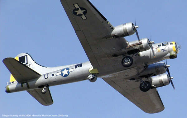
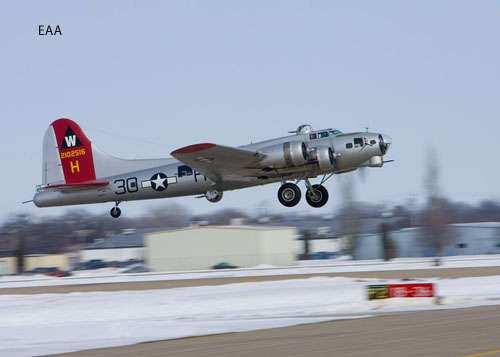
The plane that crashed was a B-17, or a Flying Fortress. More specifically, it was reportedly an early G-model B-17, airframe number 42-30762.
Image of a B-17G courtesy of AeroVintage.Com
A typical G-model had a wingspan of 104 feet; length of 74 feet; height of 19 feet; and a wing area of 1,420 square feet. Equipped, they weighed in at 38,000 pounds. While they had a normal load of 55,000 pounds, their maximum burden was 72,000 pounds.
Equipped with four, Wright Cyclone, nine-cylinder, air-cooled, radial engines with General Electric B-22 exhaust-driven turbo-superchargers, each of which had 1,380 maximum horse-power rating, a B-17G could attain a maximum airspeed of 300 M.P.H. at 30,000 feet. With a 4,000-pound bomb load, they had a range of 1,850 miles. Total short-range bomb load was 17,600 pounds.
Image of a B-17G courtesy of AeroVintage.Com
Each Flying Fortress was equipped with 13, .50-caliber Browning machine guns located as follows: chin, nose, dorsal, center-fuselage, ventral, waist, and tail. Total rounds carried numbered 5,770.
The unrivaled, frontline, wartime record of the formidable B-17G made it one of the classic bombers of all time.
The Crew:
Crew no. 3349 consisted of ten men.
• Pilot: 2nd Lt. Thomas P. Smith, Jr., 26, of Chicago, Illinois
• Co-Pilot: 2nd Lt. Louis Starks, 21, of Murray, Kentucky
• Bombardier: 2nd Lt. Raymond F. Rietschel, 23, Elmont, New York
• Navigator: 2nd Lt. Alexander W. Calder, II, 20, Maplewood, New Jersey
• Radio Operator: Staff Sgt. Delmar C Spears, 21, Progue, Kentucky
• Flight Engineer & Aerial Gunner: Staff Sgt. Charles F Sturgeon, 21, Sykeston, Missouri
• Upper Aerial Gunner: Sgt. Richard H. Hayes, 30, Whiteburg, Tennessee
• Armor Gunner: Staff Sgt. Jeff W. Britton, 29, Bronsboro, Texas
• Waist Gunner & Photographer: Staff Sgt. Calvin M. Seller, 20, Denver, Colorado
• Tail Gunner: Sgt. Leonard Rogers, 20, Pulaski, New York
The Mission:
The crew was on their third night of routine navigational flight—a 1,000-mile celestial training mission—one that had them navigating from the Sioux City, Iowa Army Air Base (SCAAB) to Marquette, Michigan, and back, with 23 other Flying Fortresses.
Flaming Descent:
As the B-17 carrying crew no.3349 headed west over Lake Superior from Marquette about an hour and half past midnight, the crew noticed a leak in the oil line for engine no. 3, the right-wing engine nearest the fuselage. A half-hour later the overheated engine caught fire. As the fire spread, exposing fuel tanks and threatening the fuselage, the plane headed for the safety of land.
One by one, the crew parachuted from the flaming plane, some landing along the Union Bay shoreline, others finding themselves much further inland.
The Aftermath:
Shortly after daybreak, an Ironwood-based Civil Air Patrol plane had located the wreckage and before long, six of the survivors had made their way to "the little country store which is the center of the hamlet of Silver City," according to the The Mining Journal (Marquette, Michigan). Before long, searchers had found the remaining crewmembers, including Tail Gunner Leonard Rogers. The last to bail out, he woke up hanging from a tree by his boot. The Journal reported the B-17 had been largely demolished by the crash:
The plane, it was found, had been virtually demolished during the crash. Wings were torn off. One side of the fuselage had been burned. The motors were buried deep in the earth and mud.
Four months later:
On August 13, 1944, the crew from the Porcupine Mountains' B-17 was shot down over La Manor, France. Flak striking below the cockpit of their plane—airframe no. 42-107030, which they called Fifinella—killed the pilot. While the rest of the crew parachuted to safety, about half were captured by the Germans and held as prisoners of war. The remaining crewmembers were aided in their escape back to England by the French underground.
Salvage Operations:
A rough road was bulldozed into the 300-yard-long crash site to facilitate salvage efforts, which were to include disposal of at least 10, unexploded practice bombs loaded with sand and high explosives, collection of machine guns and ammunition, the recovery of sensitive technology such as the super-secret Norden Bombsite, etc.
Much of the plane was cut up and hauled away; some of it was left behind at a staging areas south of the wreck site; and some of it was intentionally made inoperable or burned.
At some point after officially-sanctioned salvage operations ceased, locals used a team of horses to haul a propeller and Browning .50-caliber machine gun from the wreck site. They were both put on display in Silver City. While the propeller remained on display for many years, the Browning was stolen from its display mount.
In 1991, another Browning 50-caliber machine gun was reportedly found and removed from the wreckage. It was donated to the Ontonagon County Museum.
As of 2008, a book and a Web site dedicated to the plane wreck and its crew are reportedly in the works.


Friday, July 4
Homeward bound
Since it was the last day of our adventure, we awoke early and wolfed down our breakfasts. Rucks packed and shouldered, we struck off to recon the wreck site one last time, only this time Dennis planned to make a photographic record of the debris. (Like the rest of the Porcupine Mountains Wilderness State Park, the wreckage of the B-17 is protected by law—we took only pictures, and left only footprints.)
Once Dennis had digitally recorded several pieces of the wrecked B-17, we struck off for the site of the old White Pine Extension Mine where we'd parked my van seven days earlier. The old copper mine was situated about 5,000 meters away, along the South Boundary Road.
Along the way, we eventually passed by the overgrown staging area for the original salvage operation. Scattered about the area were a half-dozen or so huge pieces of aluminum fuselage from the plane. One section appeared to include an arched entryway, what would have been a doorway to the plane's interior. Short on time, we weren't able to recon the area for additional wreck debris likely scattered about.
As we neared by my van along the South Boundary Road, we passed by the hours-old scat of both a black bear and a timber wolf.
Having safely completed our adventure—which turned out to be one of our most artifact-rich trips to date—we said our good-byes until we planned to work some bush together again, next year, on our 12-day, Canadian, Snowshoe-and-Sledge Expedition to the Arctic Ocean (lower Hudson Bay) in February.
To learn more about
the Porkies,
or plan your own adventure to this fantastic escarpment...
Point your Internet browser to the Porcupine Mountains Wilderness State Park Web site and the official Friends of the Porkies Web site.
Read Michael Rafferty's and Robert Sprague's 367-page Porcupine Mountains Companion—Inside Michigan's Largest State Park, Fourth Edition (Nequaket Natural History Associates, 2001) and Jim DuFresne's Porcupine Mountains Wilderness State Park—A Backcountry Guide for Hikers, Backpackers, Campers and Winter Visitors, Second Edition (Thunder Bay Press, 1999).
_____________________
View Dennis Waite's photo album from this trip
View trip beta page for this adventure on Backpacker Magazine's Midwest Forum
View additional, Michigan Bush Rats' photo-journals
Learn about free, Michigan Bush Rats' upcoming trips and expeditions

In
God's wilderness lies the hope of the world,
the great, fresh, unblighted, unredeemed wilderness.
—John Muir (1838-1914),
Alaska Wilderness, 1890
![]()

If
you've been able to read this Web page...
thank a Teacher;
If you've been able to read this Web page in English...
thank a Veteran.
—Author
unknown
![]()
You're here: Backpacker
Magazine :: Forums
:: Destinations
:: Midwest
Forum :: Photo-Journal
Discussion Thread :: Photo-Journal Page
You're here: TheRuckSack
:: Photo-Journal
Index Page :: Photo-Journal Page