You are here: Backpacker
Magazine :: Forums
:: Destinations
:: Midwest
Forum :: Photo-Journal
Discussion Thread :: Photo-Journal Page
You are here: TheRuckSack
:: Photo-Journal
Index Page :: Photo-Journal Page
A Michigan Bush Rats' Photo-Journal...
Off-trail Backpacking and Canyoneering Expedition
Lake Superior Provincial Park
Wawa :: Algoma District :: Ontario :: Canada
May 24 to June 2, 2008
10 Days of backpacking
and canyoneering
through the heart of Canada's
Lake Superior Provincial Park,
from the shore of Lake Superior
to the Agawa Canyon,
including travel up
the Coldwater River watershed
and a visit to Calwin Falls
By Mary Powell (NatureLady)
Flint, Michigan
© Copyright 2008E-mail author
View Dennis Waite's photo album from this trip
View Tracey R.'s photo album from this trip (128 photos!)
View Mary Powell's photo album from this trip
View Josh Moffi's photo album from this trip
View Chris Ozminski's photo and video album from this trip
View trip beta page for this adventure on Backpacker Magazine's Midwest Forum
View additional, Michigan Bush Rats' photo-journals
Learn about free, Michigan Bush Rats' upcoming trips and expeditions
Friday
The long drive north
Friday, May 23rd was cool and sunny--a good day for driving. As I traveled north on '75 it was like moving back into early spring. At home the maples and birches were leafed out. Trilliums were on the decline and trout lilies had all but disappeared. On reaching Batchawana Bay on Superior's east shore, I found birches still in catkins and maples with only a hint of green where the leaves would later be.
I arrived at the appointed rendezvous, the Voyageur Inn and Cookhouse, around 5 PM and decided on a beach walk to dispel the stupor of the long drive. A brisk breeze from the lake soon cleared the fog from my head and I marveled at the collection of driftwood along the shore. Every few feet there was a pleasingly arranged accumulation of random debris--curls of birch bark, smooth gray driftwood, tangled roots, beaver-chewed sticks, sprigs of evergreen, pieces of rock and seaweed… Photographed against the waves and the sunset, matted and framed, the images could have filled a gallery.
A quarter of a mile or so down the beach the Carp River flows into the lake. Reaching it I saw that it had resculpted the sandbar at its mouth since our trip there last fall. A flock of seagulls rested on it looking like a formation of soldiers, evenly spaced and all facing into the wind at exactly the same angle. The river blocked further travel north so I turned back toward the motel. The light of the setting sun illuminated the white towers of the huge wind farm barely visible on a peninsula across the bay--yet another reminder that change is constant and there are too few unaltered wild places....
Rendezvous
When I got back to the motel Chris had arrived and was looking for company for dinner, so we headed over to the Cookhouse. His "voyageur meat pie" and my "Caesar of the wilderness salad" (both delicious) were followed by raspberry crisp with ice cream…after which it required considerable effort to get up and return to our rooms.
As I was retrieving some gear from my car, Charlie and his daughter Tracy arrived. Veterans of last spring's trip, they were looking forward to this one. Tracy moved in with me, as the room had a bed not in use. Charlie stayed with us a while to chat before going out to their car to sleep. He would be starting the trip with a welding burn on his left foot and asked my opinion on the advisability of that.
Though sizeable, the burn appeared uninfected and being a few days old was beginning to heal. We decided it would be safe to give it a try as it would be possible to leave the trip after a couple of days if it got worse, as Chris would be going out early to return to work. (Despite the adverse conditions of the hike, including almost continually wet feet, the wound did not present any significant problems. With nightly cleaning and salve, it was healing well at the end of the trip.)
Day 1--Saturday
Breakfast at the Cookhouse
Tracy and I were up before 7 AM and peeking through the curtains to see what was in store for us. The sky was clear, but opening the door let in a very cool breeze--definitely a day for layers. Along with Chris and Charlie we headed for breakfast a bit before the appointed time of 8 AM. Dennis soon found us there and after a while Michael and Josh came in. Over a delicious meal of eggs and assorted carbs, we completed the required paperwork for the trip.
The crew for this spring's annual Canadian Backpacking Expedition. (Photo courtesy of Dennis Waite)
By 9:30 we were headed toward the Agawa Visitor Center to obtain our backcountry permits. Since we were parking in various locations, had residents and nonresidents and one leaving early, it took some advanced math to calculate the fee. Chris and I then shuttled his car to the portage trail he hoped to come out on, while the others took vehicles to the trip's planned end at Frater.
A black bear spotted by Tracey while returning from the ACR Frater Siding. (Photo courtesy of Tracey R.)
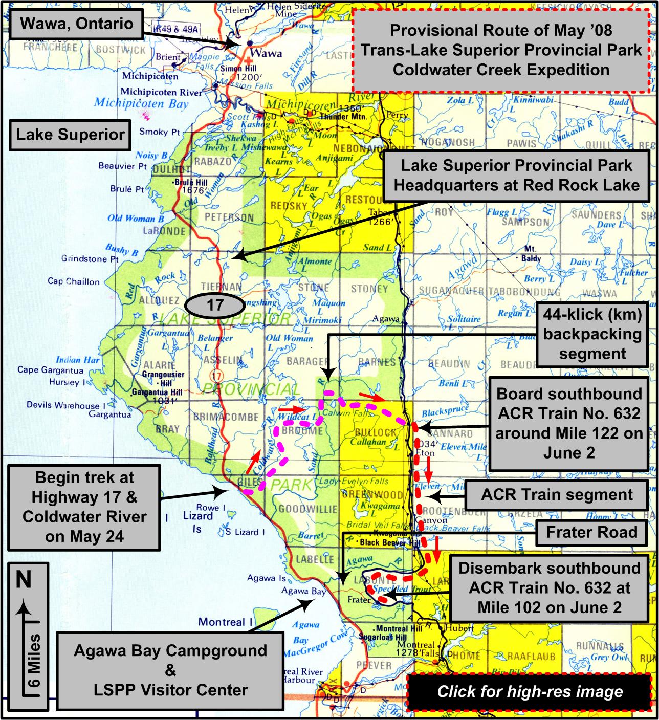
We then met near the bridge where Coldwater Creek crosses Hwy 17.
The expedition plan. (Graphic by LandNavMan)


Up a creek without a paddle…
but it's OK: this is a backpacking trip!
It was almost lunch time, but we were eager to get started and so began hiking. Though it was still sunny, scattered clouds had moved in and the breeze made the air feel cooler than the actual temperature which was around 60 degrees.
The black flies were pesty near the moving water, but not a serious problem. Trout lilies were abundant and blue bead lilies were in bud. The terrain was typical of backcountry Ontario--rocky and anything but level. A short distance upstream June Creek flowed in from the north. Not far beyond that we came upon a small falls, a picturesque drop of perhaps 10 feet or so.
Let the fishing begin…
After a brief Kodak moment at that falls, we continued climbing toward a place where three contour lines were stacked on the map. There we found a multiple cascade of 40 feet or more.
Tracey R. and BigFish at Three Fish Falls. (Photo courtesy of Tracey R.)
The fishermen (that's Josh, Chris, Dennis and Charlie) pulled out their rods. The rest of us dispersed to take pictures and explore.
NightBlazer readies his pole for fishing brook trout along the Coldwater River. (Photo courtesy of NatureLady)
We gathered after a while at the top of the falls for lunch. The fishermen hadn't had much luck, perhaps because it was midday and sunny. We dubbed the place "Three Fish Falls" though, because we'd found three good sized, but wary, trout trapped in a pond behind a pile of logs at the bottom of one of the cascades.
Tracey R. and BigFish taking a well-deserved break along the Coldwater River. (Photo courtesy of NatureLady)


First bivouac
After lunch we continued upriver. The land flattened out above the falls and the stream meandered. We followed a tributary that crossed a contour line a little way back from the main stream, but we were not rewarded with a falls there.
Remnants of an old logging road ran north to meet the river. We followed it and camped on the shore of Coldwater Creek near the remains of the bridge where the road had once crossed the stream. Chris went off to fish again and reported some luck (trout) in a pool downstream.
We fixed our evening meal and counted this first day as a good one. There were pink wisps of clouds in the clear sky at bedtime. The temp was in the lower forties and dropping.
Day 2--Sunday
Lightening up
We didn't have a minimum registering thermometer out, but Michael reported that the condensate on his tarp was frozen early in the night. When I was up around 4:30 AM, there was light frost on the bushes and moonlit clouds over the trees--beautiful! The morning was nice too-sunlit and rapidly warming.
Josh had decided that he was carrying more stuff than absolutely necessary. He and Michael sorted through his pack and cached what could be left behind for pickup at the end of the trip. Now that Josh would be carrying some semblance of what the rest of us were, we joked that we might have to hobble him in order to keep up.
Just one of many river fords for BigFish. (Photo courtesy of BigFish)

Pieces of moose
We began by following the remnant of road that we'd camped on further into the hills. In some short stretches it was open and gravelly, but most of it was heavily overgrown with evergreens and we were thankful that the moose had preserved something of a trail through them. Chris, on point, found a shed as did Josh a bit later.
A moose shovel NightBlazer found along the Coldwater River. (Photo courtesy of NightBlazer)
These finds, of course, brought out the cameras--material for the "Sheds and Skulls" page.

An early encampment
We had lunch along the river where the topos showed a pond, but the beavers had moved on and there were only hummocks and long-dead trees. After the meal we worked our way upstream to another place where the map showed a pond (hoping to fish) but the beavers had deserted this one too. We moved on upstream and camped where the river met the road again. It was mid afternoon, but a drizzling rain was falling, so we opted for a snack and a nap.
NightBlazer at one of the many waterfalls along our route. (Photo courtesy of NightBlazer)
When the rain abated, Charlie, Tracy and I went for a walk, climbing the hill behind our camp and contouring around to a small stream that dropped over dark rocks toward the river. We followed it upstream, finding several attractive little falls. The area was unusually open and park-like, the forest there being composed of maple, aspens and other mature deciduous trees rather than the dense spruce and cedar or tangles of alder that grew by the river.
When we'd had enough exploring we followed the stream down to the river and the river back to camp. Chris had been fishing, but without much success. The evening remained cloudy, damp and cool.

Day 3--Monday
Continuous precipitation
The weather deteriorated steadily after our morning coffee. Overcast turned to intermittent rain and by noon there was light hail. Needing to cross the river, we moved downstream to a shallower area with an overgrown gravel pit on the far side that Chris had explored as a possible campsite the day before. Some of us made a feeble attempt to keep our feet dry while others, being already pretty wet, just waded through.
Once across, we followed the overgrown road again for a while, coming back to the river to check out another potential fishing hole, but it, too, had been long ago deserted by the beavers.
As it was raining/hailing at lunch time, we set up a couple of tarps to avoid being pelted by the precipitation as we ate. Nevertheless, by the end of the meal we were quite chilled and glad to pack up to move on. We climbed up to Jungle Lake and explored its shores in search of the official campsite that showed on the park map. We found no sign of it, but Tracy and I walked through a beautiful boggy area that had a Pleistocene look about it--full of lacy ferns, mist and dark water.
The rain continued and the wind picked up, so we chose a sheltered area down low near the outlet of the lake to camp. After setting up shelters we gathered dripping wood and used the big knives to split it for kindling. We built a small fire to share near the edge of my tarp and spent the evening getting warm and dry and enjoying each other's company.
The crew warming up and drying out after a long spell of cold, windy, rainy weather. (Photo courtesy of NightBlazer)

Day 4--Tuesday
A cached canoe and a departure
The dawn was cool and gray but soon patches of blue sky appeared. Chris was up early to do a bit of fishing before leaving us. He discovered a cached canoe near the lake and we hurried over to see it. It had definitely been there quite a while, but it was still very seaworthy and the paddles stashed underneath were intact. Josh also got into fishing, so it was after 10 AM when we finally lifted our packs to hike.
A tandem canoe with paddles that NightBlazer found stashed in the bush near a trout lake. (Photo courtesy of NightBlazer)
Chris went a short way with us then regretfully said his good-byes and headed out on the "portage trail" that led to his car ...sort of….. He would still be needing his excellent nav skills to get back. First of all, there were few signs of the trail still to be found. Secondly, he would have to work his way around the intervening lakes where there would be no trail. Joking that he'd make it despite being handicapped by the daylight (his Internet handle being "NightBlazer"), he disappeared into the woods toward Pilot Lake.

Onward to Pinus Lake
From that point Josh took the lead, cutting an azimuth that took us to another beaver dam. We had lunch in a small clearing nearby. It proceeded to snow lightly as we ate! After lunch we worked our way north looking for another old logging road that showed on the map. When we found the line of uniform-height evergreens that indicated where a road had once been, I took a turn on point following the road clues to Pinus Lake.
We found a decent campsite almost immediately on a small peninsula, but explored most of the north shore of the lake to make sure there wasn't a better one. Most of the shoreline was swampy though so we returned to our original find and got set up. This was a pretty little lake, shallow, with banks clothed in leather leaf and sweet gale.
Back under the evergreens was a carpet of ferns, many still unfurling with the intense chartreuse color of early spring. I mentioned having read that they were good to eat when sautéed at that stage. Josh said indeed they were, and remarked that many Canadian groceries had them in the produce department. I made a mental note to look them up.
Exploring a bit before starting dinner, I saw several toads, a hummingbird checking the earliest honeysuckle blooms, and a pair of loons floating quietly on the lake. A chorus of frogs sang intermittently and in the water were schools of minnows. We relaxed, read and ate. The guys thought about fishing, but there was really no good vantage point on the shore from which to do it.
Tracey R. fording one of the many waterways along our 10-day route. (Photo courtesy of Tracey R.)

Day 5--Wednesday
A leisurely morning
I awoke to the sound of geese complaining about our presence. There was sunlight on my tarp but the thermometer read 30 degrees. A mist blanketed the lake and I could hear water trickling over the beaver dam nearby--very peaceful! As usual, we took our time with cooking, eating, and packing.
The morning's hike began with Tracy on point and Michael showing her the finer points of his favorite art, land navigation. She lead us north, back to the old logging road, which we followed for awhile. Then we bushwhacked past Acer Lake stopping for lunch at the far end.
As we resumed our hike after the meal, Michael actually made mention of the profusion of trout lilies we were seeing. This was likely more in deference to our botanical interests than because he was intrigued himself. Flowers seem to be just a detail of the woods for him, though an unusual concentration of bloom might serve as a temporary land mark, as in a comment like, "Our azimuth goes just to the left of that rock with all the yellow flowers around it." :)
Crossing the Sand
We the turned north for a short distance, traveling on yet another segment of old logging road. When we came to a ravine that ran NE, we turned into it, following it down to the Sand River. We emerged from the tag alders along the shore to an awesome view of Calwin Falls thundering over a rocky ledge on the far side of a large pool of dark water. We soaked up the view and took plenty of pictures before moving on to our next task which was crossing the river.
Calwin Falls on the Sand River. (Photo courtesy of Dennis Waite)
The Sand River in May is neither small nor slow, and its water is cold. Immediately below the falls is a broad swirling pool and below that is a section of rapids. We headed downstream. Michael had in mind to cross at the pool below the rapids. The river is wide there, more than a hundred feet, and it's deep, but relatively slow and unobstructed. There aren't any major hazards immediately below that area.
Preparation for the crossing took some time. Michael meticulously supervised wrapping of the packs and the making of PFD's from our sleeping pads. Waiting for the swim the water seemed to grow darker, colder, deeper… When the equipment was ready, he reviewed our plan, making sure that each of us felt willing and able to do it.
That confirmed, he dropped off the rocks into the water with a loud "EEEE HAA" and swam across, towing behind him the line that would be used to ferry the packs. When he was safely ashore, his pack was clipped to the rope with a carabiner, set gently into the water and towed across. Its broad, round shape floated stably and high in the water. One at a time we followed, clipping our packs to the line, watching them ferry across, then swimming over after them holding the rope.

Glitches add to the suspense
Fortunately there were no major problems, though a couple of small glitches occurred. Dennis slipped on the wet rocks and went under with his glasses on. It seemed to take a long time for him to surface. Luckily his glasses stayed with him. When Tracy's turn came, her pack somehow came unclipped from the rope and was headed downstream on its own until she gamely jumped in and retrieved it. When we were all on the far side changing into dry clothes in the last of the afternoon sun, there was a lot of cheerful banter and sharing of perceptions of the experience. It was good to be there! And nothing of consequence got wet!
Charlie R. works his rucksack across the Sand River with ropes. (Photo courtesy of BigFish)
The crossing behind us, we headed upstream to spend the night in the canoe campsite below the falls. We milled around a bit choosing our real estate there, being unused to relatively flat and brush-free ground. It ended up being a bit of a squeeze to get everyone in: the corners of several tarps were overlapping. The fishermen were eager to get their lines in the water. After dinner Charlie caught three decent-sized trout.
BigFish with a nice brook trout he pulled out of the pool below Calwin Falls. (Photo courtesy of BigFish)


Day 6--Thursday
Sheer Decadence: nice weather and a short
hike
Awakening to sunshine two days in a row seemed too good to be true…AND we got to start the day with a sample of Charlie's trout--MMMM! After that leisurely breakfast we broke camp and ambled slowly upstream. We didn't have a lot of distance to cover and it was definitely a beautiful day--mid sixties by late afternoon. We took quite a few breaks and the guys tossed their lines into the water here and there.
Shortly after lunch we encountered a team of four park staff traveling downstream in a canoe. They seemed surprised to see us and stopped to chat. They confirmed Michael's supposition that the open area where we were talking (which appeared to have been hastily cleared) was the location of an emergency helo evac several years ago.

BigFish with a very unusual, duck-like piece of beaver-chewed wood. (Photo courtesy of NatureLady)
When the maintenance crew bade us adieu, we continued upstream to the next canoe campsite located by a small falls near Sandy Mountain. As it was warm and sunny, bathing seemed like a great idea after setting up camp, and most of us disappeared into the alders along the shore in search of a spot that accommodated our preferences. I found a great one upstream--a flat rock in a couple feet of water with a deep area beyond to swim in. It is amazing what clean hair and a change of underwear can do for your outlook on life!
Warm weather does have its downside though: the evening was a bit buggy. Being near the falls it was a good fishing spot and several were caught there. We ate dinner and chatted about gear and trips 'til bedtime.
Day 7--Friday
Climbing Sandy Mountain
In the morning the sky was overcast and the temperature in the lower forties again. Breakfast was relaxed as usual and the conversation revolved around stoves. Seemed like everyone left the discussion with their preferences unchanged….
We headed up Sandy Mountain which looked interesting on the topo because its top has three distinct peaks with a small lake in the middle--complete with islands. "Mountain" is a slight exaggeration: it stands about three hundred feet above the river. The contours are closely stacked though and the terrain consists of forested rocky ledges--so getting to the top would be a bit of work. It was Charlie's turn on point and he employed his favorite nav technique: using the "GO TO" function on his GPS. He was adept at it, and it did allow us to work around the terrain without losing sight of our goal.
More rain…
By lunch time the gray sky had progressed to light rain and we brought out the tarps. We'd stopped in a fairly open area of hardwoods, but, having the whole afternoon, decided to recon around the lake to see what else was available as a campsite. We didn't find a better camp spot, but we did see some huge old growth trees and a beautiful cedar swamp with assorted ferns, skunk cabbage and a carpet of moss.
LandNavMan practicing his trade with map and compass. (Photo courtesy of NatureLady)
By early evening we'd settled under our tarps, stashed the items too damp to dry with body heat and fixed our dinner. We talked and got some reading done. The rain continued far into the night, kind of a peaceful patter on the tarps.

Day 8--Saturday
Gray and wet again…
We awoke to fog, dripping trees and frog songs. Sandhills called in the distance across the lake. Our gear wasn't any wetter, but it certainly hadn't dried either. Even the loons looked a bit bedraggled. We fixed breakfast and packed. Still there was no sign of the sun.
Carol Lake
So we packed up, folding the soggy tarps last, and we started off down the mountain through the dripping woods. Near the bottom we worked our way along Carol Lake and then beyond.
Mass Destruction of the forest
Soon after crossing into Bullock Township, which was sold to a timber magnate by the ACR several years ago, we came upon the mass destruction of forest that a clear cut is.
A huge road of mud and rock had been bulldozed across the hills. It stretched into the distance, lined on both side by giant tangled piles of stumps and trimmings presumably waiting to be burned. Beyond the piles the terrain was barren except for scattered snags and battered saplings. The desolation was oppressive.
Looking on the bright side
Fortunately Mother Nature never gives up. Already new vegetation was struggling to cover the barren soil and rock. The openness encouraged a profusion of flowers, albeit aliens, such as hawkweed, dandelions and Queen Anne's lace. We walked awhile in the intermittent drizzle, more or less silent.
Then we began to discuss the positive aspects of the situation: 1) it would be easy to have a fire in this area and leave no sign afterward 2) there was definitely a limitless supply of firewood. We would be warm and dry tonight! We continued down the road hoping to find a scrap of forest near a water supply where we could camp.
We ended up in a gravelly flat area bulldozed at the side of the road where it passed a small lake.
Our "row houses" in Bullock Township. (Photo courtesy of NatureLady)
Once the shelters were up, we gathered firewood, explored the area a bit and then settled in for the evening. We did, indeed, have a very nice fire--being warm and dry makes happy campers.
Warm and dry, finally. (Photo courtesy of NatureLady)
Mid evening a couple of men in heavy-duty raingear zipped by on an ATV. We surmised from the poles sticking out the back that it was a fishing expedition from one of the camps near the tracks. It wasn't long before they passed by in the opposite direction with a "mission accomplished' look about them.
BigFish's broken bowie knife; not all metal is forged equally. (Photo courtesy of BigFish)


Day 9--Sunday
To the tracks and beyond
By morning the rain had stopped. The sky was overcast with small but promising patches of blue. After breakfast we packed up and erased the signs of our fire. The ACR tracks which were our destination, more or less, were only about five miles away so the hiking was very relaxed. After days of damp boots my feet were rejoicing in sandals. We considered visiting Tom and Shirley who own Windy Lake Lodge, but having no way to tell if they were home, we didn't turn off at their road.
NatureLady's newt. (Photo courtesy of Tracey R.)

Options and a decision…
It was lunchtime when we reached the tracks and we settled in the shade to eat and consider our options for the night since there is no southbound train on Sunday. One possibility was to camp atop Black Spruce Mountain which loomed above us across the Agawa River. Rocky outcrops along the edges give one an awesome view of the surrounding area. Getting up there, however, would have taken most of the afternoon.
We chose the less strenuous option of hiking about half an hour along a trail that ran up the Black Spruce River which flows into the Agawa nearby. This trail leads to a campsite beside a pond just above the third falls upriver. Once there, we set up camp and spent an idyllic afternoon fishing, swimming, sunbathing, exploring and taking pictures.
Upper Black Spruce Falls below the eastern flank of Black Spruce Mountain. (Photo courtesy of Dennis Waite)
The clouds had blown off to the east and a peaceful evening meal was followed by a beautiful sunset which was reflected on the sheer rock face across the pond. The sky darkened and the stars came out, followed by the moon. We'd seen little of the night sky on this trip with all the rain, so we lay back to enjoy it. A great last evening in the bush!

Day 10--Monday
All aboard
Morning brought more sunshine. We took our time with breakfast. Most of us were down to our last scraps of cheese and granola so packing lunch took little time. On the way back to the tracks we stopped to photograph the lower falls. Then we joined several other travelers at the tracks to wait for the train.
It came only a couple of hours after it was scheduled, which is pretty much on time for a flag stop train. We loaded our gear and ourselves into one of the baggage cars.
Riding in the baggage car. (Photo by Tracey R.)
After purchasing tickets from the conductor we arranged ourselves near one of the open doors or on a platform between cars to enjoy the scenery along the tracks to Frater where Michael's van and Dennis' car awaited us.
Bridal Veil Falls in the Agawa Canyon proper. (Photo courtesy of NatureLady)
Dennis, who had the longest drive, headed south after our good-byes.
The rest of us boarded Michael's van for return to our vehicles parked near Coldwater Creek. Michael and Josh still had to hike back for the cached equipment, while Tracy, Charlie and I headed for the Voyageur Inn and a taste of REAL food.
Mike and Josh stopped by there later to report the success of their retrieval mission, which included Josh finding another moose shed as he approached the Coldwater.
A moose shovel BigFish found along the the north bank of the Coldwater River. (Photo courtesy of BigFish)
Another great trip--10 days of wonderful wilderness time and good company--was in the bag!
_____________________
E-mail author
View Dennis Waite's photo album from this trip
View Tracey R.'s photo album from this trip (128 photos!)
View Mary Powell's photo album from this trip
View Josh Moffi's photo album from this trip
View Chris Ozminski's photo and video album from this trip
View trip beta page for this adventure on Backpacker Magazine's Midwest Forum
View additional, Michigan Bush Rats' photo-journals
Learn about free, Michigan Bush Rats' upcoming trips and expeditions


In
God's wilderness lies the hope of the world,
the great, fresh, unblighted, unredeemed wilderness.
—John Muir (1838-1914),
Alaska Wilderness, 1890
![]()

If
you've been able to read this Web page...
thank a Teacher;
If you've been able to read this Web page in English...
thank a Veteran.
—Author
unknown
![]()
You are here: Backpacker
Magazine :: Forums
:: Destinations
:: Midwest
Forum :: Photo-Journal
Discussion Thread :: Photo-Journal Page
You are here: TheRuckSack
:: Photo-Journal
Index Page :: Photo-Journal Page