Location: TheRuckSack home page > upcoming trips page > trip page
Sierra Club Wilderness
trips and expeditions
Chapter: Michigan (Mackinac)
Group: Central Upper Peninsula (CUPG)
Leader: Michael Neiger, Marquette,
Michigan (Web site; e-mail;
bio)
Review journal no. 1 from this completed trip.
April 2-5,
2004
Intermediate-level
backpacking & elk tracking
High Country Pathway area & surrounding
bush
Montmorency & Otsego Counties
Northern Lower Michigan, northeast of Gaylord
8 a.m. Fri to
midday on Mon.
Club fee:
$10.
Signup by March 17 appreciated
Route advisories:
We'll explore the southern limits of the High Country Pathway as well as the adjoining wilderness, both of which are located within the Pigeon River State Forest--prime elk country.
Highlights include views from Black River Fire Tower Ridge, Old Baldy Hill, Rattlesnake Hills, and Eagle Ridge; Black River, East Branch of Black River, and Rattlesnake Creek; old railroad grades; Green Swamp.
Involves off-trail travel, river fords, and swamp cuts.
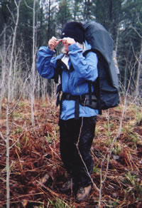
Jane Beckwith of East Lansing
cuts an azimuth
with her prism-sighting
orienteering compass
as she leads the group
through the bush
in the Pigeon River State Forest
on a May 2002 trip.
(Photo by Mary Powell)
Bivouac advisories:
This is not a basecamp trip. We will move each day and bivouac in a different location each night, often deep in the bush and far from roads, dry & level campsites, potable water, toilets, and fire rings.
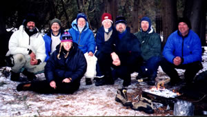
Michael Neiger (Marquette, Mi), Dennis Waite (Berrien Springs, Mi), Gail Bosi (Midland, Mi), Mary Powell (Flint, Mi), Mary Ann Hayman (Sault Ste. Marie, Ontario), Jay Hanks (Perry, Mi), Chris Ozminski (Attica, Mi), and Dave Mansfield (Davison, Mi) enjoy their remote bivouac on the Pigeon River's seldom visited Beaver Dam Island on a December 2003 trip. (Photo courtesy of Gail Staisil)
Free wilderness skills and educational opportunities, by prior arrangement:
- Hands-on GPS instruction--learn how to configure your GPS unit and use it to while under way in the bush.
- Hands-on map and compass instruction--learn how to plot azimuths on your topo map with your compass, cut azimuths through the bush with your compass, and solve complex navigational challenges using a variety of tactics and strategies including ranger pacing beads, aiming off, etc.
- Tarp rigging--learn how to rig a tarp and bivouac under it.
- River fording--learn how to waterproof your rucksack and how to ford or swim waterways crossing your route.
- Low-impact fire laying, where appropriate only--learn how to build and maintain a small, Indian-style fire without scarring the ground and without leaving any trace.
- Low-impact travel techniques--learn how to travel and bivouac "lightly" in the bush while at the same time minimizing your impact on the wilderness.
Participant requirements:
- Notice: please review the homepage on this Web site for additional wilderness tripping information and requirements.
- 18 years old or older
- non-smoker and non-drinker
- physically fit (good aerobic endurance)
- adventurous spirit
- swimmer
- experienced, 20-degree-rated backpacker
- fully equipped with lightweight backpacking gear including rucksack, bivouac gear, survival gear, foul-weather gear, rations, stove, etc.
Specialized equipment required:
- In-pocket survival kit (knife, matches, firestarters, compass, whistle, magnesium firestarter)
- River-fording footwear
Land Nav Team quads:
- 1:24000 Hardwood Lake, Michigan
- 1:24000 Saunders Creek, Michigan
- 1:24000 Hetherton, Michigan
- 1:24000 Atlanta, Michigan
Topo map ordering information
Specialized land nav gear recommendations
Review journals and photos from past trips to this area:
- photo-journal from '03 trip
- photo-journal from '03 trip
- photo album from '03 trip
- photo-journal from '02 trip
- photo album from '02 trip
- photo album from '02 trip
- photo-journal from '02 trip
- photo-journal from '02 trip
- photo-journal from '01 trip
Contact trip leader for trip application form:
Return to upcoming trips page and read about another trip