Location: TheRuckSack home page > upcoming trips page > trip page
Sierra Club Wilderness
trips and expeditions
Chapter: Michigan (Mackinac)
Group: Central Upper Peninsula (CUPG)
Leader: Michael Neiger, Marquette,
Michigan (Web site; e-mail;
bio)
Review journal no. 1 and photo album no. 1 from this completed trip
April 30 to
May 3, 2004
Intermediate-level
backpacking
North Country Trail area & surrounding
bush
Mackinac County
Eastern Upper Michigan, northwest of St. Ignace
8
a.m. Fri to midday on Mon.
Club fee: $10.
Signup by April 14 appreciated
Route advisories:
We'll explore portions of the North Country Trail as well as the adjoining wilderness around Brevort Lake in the Hiawatha National Forest and the Lake Superior State Forest.
Highlights include Pointe aux Chenes Marsh, Brevort Lake, view of Big Mac, and numerous creeks and streams.
Involves off-trail travel, river fords, and swamp cuts.
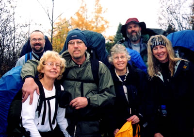
Jay Hanks (Perry, Michigan), Mary Powell (Flint, Michigan), Dan Soper (Flint, Michigan) Many Ann Hayman (Sault Ste. Marie, Ontario), Michael Neiger (Marquette, Michigan), and Gail Staisil (Midland, Michigan) enjoying the Hiawatha National Forest on a November, 2003 trip. (Photo courtesy of Gail Staisil)
Bivouac advisories:
This is not a basecamp trip. We will move each day and bivouac in a different location each night, often deep in the bush and far from roads, dry & level campsites, potable water, toilets, and fire rings.
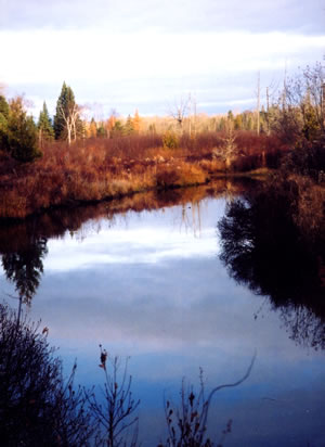
Our Friday night bivouac area was a pine-needle-covered ridge overlooking the North Branch of the Carp River, just downstream of its confluence with Bissel Creek, deep in the interior of the non-motorized Mackinac Wilderness Tract in Mackinac County on a November, 2003 trip. (Photo courtesy of Gail Staisil)
Free wilderness skills and educational opportunities, by prior arrangement:
- Hands-on GPS instruction--learn how to configure your GPS unit and use it to while under way in the bush.
- Hands-on map and compass instruction--learn how to plot azimuths on your topo map with your compass, cut azimuths through the bush with your compass, and solve complex navigational challenges using a variety of tactics and strategies including ranger pacing beads, aiming off, etc.
- Tarp rigging--learn how to rig a tarp and bivouac under it.
- River fording--learn how to waterproof your rucksack and how to ford or swim waterways crossing your route.
- Low-impact fire laying, where appropriate only--learn how to build and maintain a small, Indian-style fire without scarring the ground and without leaving any trace.
- Low-impact travel techniques--learn how to travel and bivouac "lightly" in the bush while at the same time minimizing your impact on the wilderness.
Participant requirements:
- Notice: please review the homepage on this Web site for additional wilderness tripping information and requirements.
- 18 years old or older
- non-smoker and non-drinker
- physically fit (good aerobic endurance)
- adventurous spirit
- swimmer
- experienced, 20-degree-rated backpacker
- fully equipped with lightweight backpacking gear including rucksack, bivouac gear, survival gear, foul-weather gear, rations, stove, etc.
Specialized equipment required:
- In-pocket survival kit (knife, matches, firestarters, compass, whistle, magnesium firestarter); Sierra Club survival kits are also available free of charge.
- River-fording footwear
Land Nav Team quads:
- 1:24,000 Brevort, Michigan
- 1:24,000 Kenneth, Michigan
Topo map ordering information
Specialized land nav gear recommendations
Review journals and photos from past trips to this area:
- photo-journal from '03 trip
- photo-journal from '03 trip
- photo album from '03 trip
- photo-journal from '02 trip
- photo album from '02 trip
- photo-journal from '01 trip
Contact trip leader for trip application form:
Return to upcoming trips page and read about another trip