Location: TheRuckSack home page > upcoming trips page > trip page
Sierra Club Wilderness
trips and expeditions
Chapter: Michigan (Mackinac)
Group: Central Upper Peninsula (CUPG)
Leader: Michael Neiger, Marquette,
Michigan (Web site; e-mail;
bio)
Review photo album no. 1, photo album no. 2, photo album no. 3, trip journal no. 1, trip journal no. 2, and three moose sheds from this completed trip
May 22-30,
2004
18th Annual (Spring)
Canadian Backpacking Expedition
Blackspruce
River Valley & Mount Baldy
**5-23-04: Trip
changed from Mount Baldy
to Austin Lake Mountain
and Fire Tower, 11 Mile River
Agawa Canyon area
East of Lake Superior Provincial Park
Algoma District
Southeast of Wawa, Ontario
9
a.m. Sat to mid-afternoon on Sun.
Club fee: $20 (U.S. funds).
Algoma Central Railroad fare: $50 (Canadian funds)
Park camping permits: if any, $6.50 per night (Canadian
funds)
Signup by May 6 required
Notice: this long-range, high-skills, extremely remote trip requires a 11-day ration load and foul-weather survival gear. This is not a fair-weather trip. It is only suitable for those hard-core, dyed-in-the-wool backpackers who have strong minds and bodies and who have an insatiable desire to recon remote, untrammeled bush.
Notice: all participants in this expert-level trip must have successfully completed at least one prior wilderness trip with the trip leader.
Tentative route:
This spring's backpacking expedition has the potential to be one our most ambitous and challenging ever.
After a 5-mile drive along an old, rocky, washout-prone jeep trail that climbs 500 feet from Highway 17 to the Algoma Central Railway's remote and abandoned Frater Station at milepost 102, we'll hand-signal the No. 1 bush train to stop and pick us up.
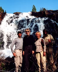
Alex, Gail, Mary,
and Michael at
one of the cascades
of the remote Parch Creek Falls
on a spring '03 trip
to the Agawa Canyon.
(Photo by Alex Chard)Once aboard, we'll pay the conductor our fare and sit back and enjoy a near hour-long ride down into, through, and out of the spectacular Agawa Canyon.
At milepost 122.5, where the confluence of the mighty Agawa River and the Blackspruce River are overlooked by Blackspruce Mountain, we'll detrain and begin our recon of the seldom-visited Blackspruce River Valley. Our first nights bivouac will be at Blackspruce Falls, which is located about a klick (1 kilometer) or so up the valley.
Along the way, we'll take time to relax, fish for trout with a handline, read, swim, take photographs, and explore.
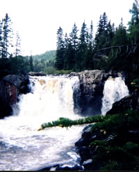
Lady Evelyn Falls
along the
Sand River
on a spring '03 trip.
(Photo by Mary Powell)Our ultimate goal is to work our way up the Blackspruce River Valley--taking in its rapids and falls along the way--to Blackspruce Lake and then on to Mount Baldy (2005', non-technical), a rock promitory with its own namesake lake and island situated on a plateau just below the summit.
A few klicks before Mount Baldy, we will recon a section of hydro line for a potential two-week expedition in 2005.
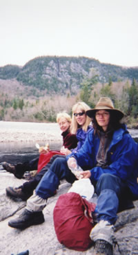
Mary, Gail, and Sue
enjoy lunch at Burnt Rock Pool
along the bank of
the Agawa River.
The north wall of the canyon,
visible in the background,
is a foothill of Kwagama Hill
on a spring '02 trip.
(Photo by Mary Powell)Once we complete a bivouac atop Mount Baldy, and drop a handline in Mount Baldy Lake to check it for monster native brook trout, we'll head north to check out the headwaters of the Agawa River.
From the headwaters of the Agawa River we will hike southwest to return to the Algoma Central Railway, where we will flag down the No. 2 bush train for a ride back to our vehicles at the abandoned Frater Station.
Route advisories:
Involves off-trail travel, river fords/swims, lake
narrows ford/swims, and swamp cuts through extremely remote, seldom-traveled, bug-infested, Canadian wilderness on the remote backside of Lake Superior Provincial Park.
The ACR's Agawa Canyon Station as viewed from high atop the west canyon wall, looking south, on a spring '01 trip. (Photo by Mary Powell)
Access is by helo, seaplane, or bush train only. Evac during isolated portion of route will require helo support.
Bivouac advisories:
This is not a basecamp trip. We will move each day and bivouac in a different location each night, often deep in the bush and far from roads, dry & level campsites, potable water, toilets, fire rings, and other humans.
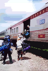
En route back
to their vehicles
at the long-abandoned
Algoma Central Railway
Frater Station,
Mara and Mary
hoist their rucksacks
into the ACR
No.2 baggage car
in the Agawa Canyon,
on a spring '01 trip.
(Photo by Loretta Crum)Free wilderness skills and educational opportunities, by prior arrangement:
- Hands-on GPS instruction--learn how to configure your GPS unit and use it to while under way in the bush.
- Hands-on map and compass instruction--learn how to plot azimuths on your topo map with your compass, cut azimuths through the bush with your compass, and solve complex navigational challenges using a variety of tactics and strategies including ranger pacing beads, aiming off, etc.
- Tarp rigging--learn how to rig a tarp and bivouac under it.
- River fording--learn how to waterproof your rucksack and how to ford or swim waterways crossing your route.
- Low-impact fire laying, where appropriate only--learn how to build and maintain a small, Indian-style fire without scarring the ground and without leaving any trace.
- Low-impact travel techniques--learn how to travel and bivouac "lightly" in the bush while at the same time minimizing your impact on the wilderness.
Participant requirements:
- Notice: please review the homepage on this Web site for additional wilderness tripping information and requirements.
- 18 years old or older
- non-smoker and non-drinker
- very physically fit (good aerobic endurance)
- adventurous spirit
- swimmer
- experienced, 20-degree-rated backpacker
- fully equipped with lightweight backpacking gear including rucksack, bivouac gear, survival gear, foul-weather gear, rations, stove, etc.
- Notice: participants in this remote, long-range, high-skills, advanced-level trip must have successfully completed at least one prior wilderness trip with the trip leader.
Specialized equipment required:
- In-pocket survival kit (knife, matches, firestarters, compass, whistle, magnesium firestarter); Sierra Club survival kits are also available free of charge.
- River-fording footwear
Land Nav Team quads:
- 1:50000 Canadian Map no. 41 N/9, Blackspruce Lake
- 1:50000 Canadian Map no. 41 N/16, Kinniwabi Lake
- 1:50000 Canadian Map no. 41 N/10 & 41 N/11, Old Woman Lake
Optional, more detailed maps, carried by leader
- 1:20000 Ontario Base Map no. 20-16-6800-52600
- 1:20000 Ontario Base Map no. 20-16-6800-52700
- 1:20000 Ontario Base Map no. 20-16-6800-52800
- 1:20000 Ontario Base Map no. 20-16-6900-52600
- 1:20000 Ontario Base Map no. 20-16-6900-52700
- 1:20000 Ontario Base Map no. 20-16-6900-52800
- 1:20000 Ontario Base Map no. 20-16-6900-52900
- 1:20000 Ontario Base Map no. 20-16-7000-52600
- 1:20000 Ontario Base Map no. 20-16-7000-52700
- 1:20000 Ontario Base Map no. 20-16-7000-52800
- 1:20000 Ontario Base Map no. 20-16-7000-52900
Topo map ordering information
Specialized land nav gear recommendations
Review journals and photos from past trips to this area:
- photo-journal from '03 trip
- photo album from '03 trip
- photo-journal from '02 trip
- photo album from '02 trip
- photo-journal from '01 trip
Contact trip leader for trip application form:
Return to upcoming trips page and read about another trip