Location: TheRuckSack home page > upcoming trips page > trip page
Sierra Club Wilderness
trips and expeditions
Chapter: Michigan (Mackinac)
Group: Central Upper Peninsula (CUPG)
Leader: Michael Neiger, Marquette,
Michigan (Web site; e-mail;
bio)
Review photo album no. 1, photo album no. 2, trip journal no. 1, and trip journal no. 2 from this completed trip
July 1-11,
2004
Lake Superior Shoreline
Backpacking
Intermediate
level, leisurely pace
100% on-trail route through rugged, challenging terrain
Coastal Trail, optional Gargantua Mountain
Lake Superior Provincial Park
Algoma District
South of Wawa, Ontario
8
a.m. Thursday to mid-afternoon on Sunday
Club fee: $20 (U.S. funds).
Park camping permits: $65 (Canadian funds)
Leaders: Michael Neiger,
Marquette, mneiger@hotmail.com
Mary
Powell, Flint, powell_mm@hotmail.com
Signup by June 16 appreciated
Size limit: 7 trekkers plus 2 leaders
Notice: all participants in this intermediate-level trip must have successfully completed at least one prior wilderness trip with the trip leader or have appropriate experience.
Food cache: positioned for mid-trip resupply
Tentative route:
This summer's backpacking trip will be along the rugged and rocky east coast of Lake Superior. We'll also make a short, crosscountry trip to Gargantua Mountain and a remote campsite situated along the lakeshore at the foot of the mountain. Along the way, we'll take time to relax, identify flowers, read, swim, take photographs, andexplore.
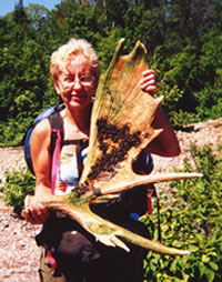
Mary Powell of Flint
holds one of three
moose shovel sheds
she found deep
in the heart
of Ontario's
Lake Superior Provincial Park.
To view the other
moose sheds
found on this trip,
visit the Sheds 'n Skulls
page on this Web site.
(Photo by Mary Powell)View Gail Staisil's
Photo Album from this coastal trail tripRoute advisories:
Some sections of this trail are very rugged and challenging. Other sections are very slippery when wet.
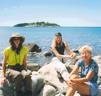
Sue Schenk-Drobny,
Gail Staisil,
and Mary Powell
enjoy a break along
the shore of
Lake Superior.
Gargantua Island is
just offshore.
(Photo by Gail Staisil)
Bivouac advisories:
This is not a basecamp trip. We will move each day and bivouac in a different location each night, often deep in the bush and far from roads, dry & level campsites, potable water, toilets, fire rings, and other humans.
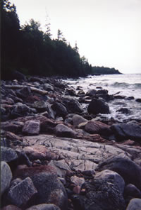
Waves break
along the
rock-strewn
shoreline of
Lake Superior.
(Photo by Mary Powell)
Free wilderness skills and educational opportunities, by prior arrangement:
- Hands-on GPS instruction--learn how to configure your GPS unit and use it to while under way in the bush.
- Hands-on map and compass instruction--learn how to plot azimuths on your topo map with your compass, cut azimuths through the bush with your compass, and solve complex navigational challenges using a variety of tactics and strategies including ranger pacing beads, aiming off, etc.
- Tarp rigging--learn how to rig a tarp and bivouac under it.
- River fording--learn how to waterproof your rucksack and how to ford or swim waterways crossing your route.
- Low-impact fire laying, where appropriate only--learn how to build and maintain a small, Indian-style fire without scarring the ground and without leaving any trace.
- Low-impact travel techniques--learn how to travel and bivouac "lightly" in the bush while at the same time minimizing your impact on the wilderness.
Participant requirements:
- Notice: please review the homepage on this Web site for additional wilderness tripping information and requirements.
- 18 years old or older
- non-smoker and non-drinker
- very physically fit (good aerobic endurance)
- adventurous spirit
- swimmer
- experienced, 30-degree-rated backpacker
- fully equipped with lightweight backpacking gear including rucksack, bivouac gear, survival gear, foul-weather gear, rations, stove, etc.
- all participants in this intermediate-level trip must have successfully completed at least one prior wilderness trip with the trip leader or have appropriate experience.
Specialized equipment required:
- In-pocket survival kit (knife, matches, firestarters, compass, whistle, magnesium firestarter); Sierra Club survival kits are also available free of charge.
- River-fording footwear
Land Nav Team quads:
- 1:63000 Lake Superior Provincial Park Map
- 1:50000 Canadian Map no. 41 N/7, Agawa Bay
- 1:50000 Canadian Map no. 41 N/10 & 41 N/11, Old Woman Lake
Optional, more detailed maps, carried by leader
- 1:20000 Ontario Base Map no. 20-16-6500-52600
- 1:20000 Ontario Base Map no. 20-16-6600-52500
- 1:20000 Ontario Base Map no. 20-16-6600-52600
- 1:20000 Ontario Base Map no. 20-16-6700-52400
- 1:20000 Ontario Base Map no. 20-16-6700-52500
Topo map ordering information
Specialized land nav gear recommendations
Review journals and photos from past trips to this area:
- photo album from '02 trip
- photo-journal from '02 trip
Contact trip leader for trip application form:
Return to upcoming trips page and read about another trip