Location: TheRuckSack home page > upcoming trips page > trip page
Sierra Club Wilderness
trips and expeditions
Chapter: Michigan (Mackinac)
Group: Central Upper Peninsula (CUPG)
Leader: Michael Neiger, Marquette,
Michigan (Web site; e-mail;
bio)
Review trip journal and photo album from this completed trip
December 3-6, 2004
Winter camping & elk tracking
This
early-winter backpacking trip will involve a cross-country trek through
the non-motorized Green Timbers Wilderness Tract as well as an exploration
of the wilderness along the western limits of the High Country Pathway.
This area is home to the majestic Elk and we'll be keeping an eye out
for this elusive animal as well as its tracks.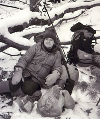
Milton French
enjoys an
hour-long
lunch break
in a protected draw
at the foot of
Rattlesnake Hill
on a 2002 trip.
(Photo by Gail Staisil)
Destination:
High Country Pathway
area & surrounding bush
Otsego and Cheboygan Counties
Northern Lower Michigan, northeast of Gaylord
Experience level:
Intermediate-level,
minus 10 degree wintercamping
with backpack
Difficulty:
Strenuous
Off-trail/on-trail rating:
80 percent off-trail
map & compass recon
Participant requirements:
-- Notice:
please review the homepage on this Web site
for general wilderness tripping requirements
-- 18 years old or older
-- non-smoker and non-drinker
-- very physically fit (good aerobic endurance)
-- adventurous spirit
-- proficient swimmer
-- prior wilderness tripping experience
-- fully equipped with lightweight backpacking gear
including rucksack, bivouac gear,
survival gear,
foul-weather gear, rations, stove,
etc.
Bivouac
advisory:
This
is not a basecamp trip.
We will move each day
and bivouac in a different location each night,
often deep in the bush and far from roads,
dry & level campsites, potable water, toilets, and
fire rings.
Trip info:
-- 8 a.m. Friday
to late afternoon Monday
-- Club fee: $10
-- Sign up
by November 18 appreciated
-- Contact trip
leader for sign up, or application form if new
-- Review journals
and photos from similar wilderness trips
Specialized equipment required:
-- In-pocket survival
kit (knife, matches, firestarters,
compass, whistle); Sierra Club survival
kits can be
borrowed free of charge
-- River-fording footwear
Rations required:
-- Breakfasts--4
-- Snacks--4
-- Lunches--4
-- Dinners--3
-- Backup rations--1 full day
-- Rations and stoves info
Additional
destination info:
-- Pigeon River State Forest Headquarters,
1-989-983-4101
-- Read "Field
Guide to the High Country Pathway," 1997, by the Pigeon River Country
Association, P.O. Box 122, Gaylord, Michigan 49735.
-- Read "High Country Pathway," 1990 map,
Michigan Department of Natural Resources, Information Services Center,
P.O. Box 30028, Lansing, Michigan 48909.
-- Read "Hiking Michigan," by Mike Modrzynski
(Falcon Press, 1996).
-- Read "Backpacking in Michigan," second
edition, by Pat Allen and Gerald L. DeRuiter (University of Michigan Press,
1989).
-- Read "Hiking with the Herd," by James Campbell,
in Backpacker Magazine, Oct '00, page 97.
-- Search destination in http://www.google.com
search engine
Travel
info:
-- Driving
maps
-- Road conditions and weather
reports
-- Tourism info
-- Road trip gear
Wilderness skills and resources info:
-- Backpacking
skills
-- Land nav skills
-- River fording skills
-- Water purification
skills
-- Lightning safety
-- Low-impact skills
-- Backpacking links, books,
& vendors
-- Ultralight backpacking
links, books, & vendors
--
Dressing warm skills
-- Sleeping warm skills
-- Winter-camping skills
-- Ice-crossing skills
-- Snowshoe links, books,
& vendors
-- Winter-camping
links, books, & vendors
Emergency contacts:
-- Otsego County
Sheriff: Gaylord, 1-517-732-6484
-- Montmorency County Sheriff: Atlanta, 1-517-785-4238
-- Michigan State Police: Gaylord, 1-517-732-5141
-- Michigan State Police: Alpena, 1-517-354-4101
-- Hospital: Gaylord, 1-517-731-2100
-- Hospital: Alpena, 1-517-356-7252
-- Sierra Club Outings Department 24-hour help line:
1-888-outings
Land Nav Team Info:
Topographic maps:
1:24,000 Green Timbers, Michigan
1:24,000 Hardwood Lake, Michigan
1:24,000 Afton, Michigan
--Topo map ordering
information
--Topo map waterproofing
& GPS prep
County maps:
Otsego
County
Cheybogan County
--County map ordering
information
2004
Magnetic declination specs:
Magnetic declination
for Lat 45° 15'N, Lon 84° 30'W:
06° 40' west
UTM easting grid line to meridian
line deviation:
01° 49' east
UTM easting grid line magnetic declination:
08° 29' west
GPS
configuration specs:
Grid coordinate
system
1000-meter Universal
Transverse Mercator Grid (UTM)
UTM grid horizontal map datum:
1927 North American
Datum (NAD 27 CONUS)
UTM grid zone:
Zone 16
UTM grid hemisphere:
Northern hemisphere
Unit of measures:
Metric
Misc nav setup:
Roamer
UTM plotter scale(s):
1:24,000
Ranger pacing
beads:
Metric--9 100-meter
beads; 4 1-kilometer beads
Magnetic declination setting on compass:
0° of offset
More land nav team info
Return to upcoming trips page and read about another trip