Location: TheRuckSack home page > upcoming trips page > trip page
Sierra Club Wilderness
trips and expeditions
Chapter: Michigan (Mackinac)
Group: Central Upper Peninsula (CUPG)
Leader: Michael Neiger, Marquette,
Michigan (Web site; e-mail;
bio)
Review trip journal no. 1, trip journal no. 2, and photo album from this completed trip
March 3-8, 2005
Winter camping
This trip will be a snowshoe tour pulling cargo sledges (five, first-come, first-serve, $5-rental club sleds available by prior arrangement) just as the Ojibwa travelled for 100s of years before us. We'll explore the shoreline of Pictured Rocks National Lakeshore between Munising Falls and the Beaver Basin, which is up for Wilderness Designation. Along the way, we'll explore ice caves, ice falls, and wilderness caves that dot the shoreline as well as the park's remote backcountry.
Mary Powell
(in front of cave
on right side of photo) emerges
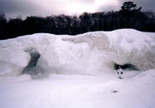 from an ice cave
along the shore of
Lake Superior
near the mouth
of the Mosquito River
in the Pictured Rocks
National Lakeshore,
March 2003.
(Photo by Mary Powell)
Destination:
Pictured
Rocks National Lakeshore:
Shoreline Trail, Chapel and Miners Basins
Alger County
Upper Michigan, east of Munising
Experience
level:
Advanced-level,
minus 20 degree wintercamping
with sledge ($5 club rental) and snowshoes
Requires prior winter-camping experience with leader
Difficulty:
Extremely strenuous
Off-trail/on-trail rating:
50 percent off-trail
map & compass recon
Participant requirements:
-- Notice:
please review the homepage on this Web
site
for general wilderness tripping requirements
-- 18 years old or older
-- non-smoker and non-drinker
-- very physically fit (good aerobic endurance)
-- adventurous spirit
-- proficient swimmer
-- prior wilderness tripping experience
-- fully equipped with lightweight backpacking gear
including rucksack, bivouac gear,
survival gear,
foul-weather gear, rations, stove,
etc.
Bivouac
advisory:
This
is not a basecamp trip.
We will move each day
and bivouac in a different location each night,
often deep in the bush and far from roads,
dry & level campsites, potable water, toilets, and
fire rings.
Trip info:
-- 8 a.m. Thursday
to mid-afternoon on Tuesday
-- Club fee: $15
-- Rental of club sledge: $5
-- PRNL Camping Permits: approximately $25
-- Sign up
by February 15 appreciated
-- Contact trip
leader to sign up, or for application form if new
-- Review journals
and photos from similar wilderness trips
Specialized
equipment required:
-- In-pocket
survival kit (knife,
matches, firestarters,
compass, whistle); Sierra Club survival
kits can be
borrowed free of charge
-- CLIMBING/CAVING HELMET: must have chin strap
and be UIAA (International Union of Alpine
Associations)-
or CEN (European Community Norm)-approved.
-- One climbing-grade carabiner
-- Whistle on parka zipper shell
-- Ice-rescue picks
Rations required:
-- Breakfasts--5
-- Snacks--6
-- Lunches--6
-- Dinners--5
-- Backup rations--1 full day
-- Rations and stoves
info
Additional destination info:
-- Pictured Rocks
National Lakeshore http://www.nps.gov/piro/
1-906-387-3700
-- Book: "Pictured Rocks National Lakeshore - -
A Guide" by Olive Anderson (1988, Bayshore Press)
-- Book: "Scenic Highlights at the Pictured Rocks
National Lakeshore and Adjacent Areas" by Richard W. Holzman (1990,
Royal Gallery)
-- Book: "By the Shining Big-Sea-Water - - The
Story of Pictured Rocks 10,000 B.C. to 1966 A.D." (1989, Bayshore
Press)
-- Book: "Backpacking in Michigan" by Pat
Allen and Gerald L. DeRuiter (1989 University of Michigan Press)
-- Book: "Michigan Ice - - An Ice Climbers Guide
to the Central Upper Peninsula of Michigan" by Bill Thompson (1998
Michigan Ice)
-- Search destination in http://www.google.com
search engine
Travel
info:
-- Driving
maps
-- Road conditions and
weather reports
-- Tourism info
-- Road trip gear
Wilderness skills and resources info:
-- Backpacking
skills
-- Land nav skills
-- River fording skills
-- Water purification
skills
-- Lightning safety
-- Low-impact skills
-- Backpacking links,
books, & vendors
-- Ultralight backpacking
links, books, & vendors
--
Dressing warm skills
-- Sleeping warm skills
-- Winter-camping
skills
-- Ice-crossing skills
-- Snowshoe
links, books, & vendors
-- Winter-camping
links, books, & vendors
Emergency contacts:
-- Pictured Rocks
National Lakeshore: 1-906-387-3700
-- Alger County Sheriff: 1-906-387-4444
-- Munising State Police: 1-906-387-4540
-- Hospital (Munising): 1-906-389-4110
-- Sierra Club Outings Department 24-hour help line:
1-888-outings
Land Nav Team Info:
Topographic maps:
1:24,000 Indian Town, Michigan
1:24,000 Wood Island SE, Michigan
1:25,000 Melstrand, Michigan
1:25,000 Grand Portal Point, Michigan
1:25,000 Trappers Lake, Michigan
--Topo map ordering
information
--Topo map waterproofing
& GPS prep
Park maps:
Pictured
Rocks Official Map and Guide (free handout)
1:62,500 Pictured Rocks National Lakeshore,
Michigan
--Order at 1-906-387-3700
County maps:
Alger
County
--County map ordering
information
2005
Magnetic declination specs:
Magnetic declination
for Lat 46° 30'N, Lon 86°30'W:
05° 16' west
UTM easting grid line to meridian
line deviation:
00° 20' east
UTM easting grid line magnetic declination:
05° 36' west
GPS
configuration specs:
Grid coordinate
system
1000-meter Universal
Transverse Mercator Grid (UTM)
UTM grid horizontal map datum:
1:24(5),000 maps:
1927
North American Datum Canada (NAD 27 CONUS)
UTM grid zone:
Zone 16
UTM grid hemisphere:
Northern hemisphere
Unit of measure:
Metric
Battery type:
Lithium, for deep
cold, or long-range use
Alkaline, for 3-season
use
Battery type setting:
Select type of battery
(lithium, alkaline, or Ni-Cad);
battery discharge-rate
differences affect meter accuracy
Misc nav setup:
Roamer
UTM plotter scale(s):
1:24,000 & 1:25,000
Ranger pacing
beads:
Metric--9 100-meter
beads; 4 1-kilometer beads
Magnetic declination setting on compass:
0° of offset
More land nav team info
Return to upcoming trips page and read about another trip