TheRuckSack > photo-journal archive index > archive page
Wilderness Tripping:
Backpacking
Pigeon River State Forest, Green Timbers Tract,
& High Country Pathway
Otsego County
Gaylord, Michigan
December 5-8, 2003
Bushwhacking Through
the Pigeon River State Forest
An Early Winter Backpacking Trip
Along the High Country Pathway
and Through the Green Timbers Tract
By Mary Powell
Flint, Michigan
Copyright 2003
E-mail author at powell_mm@hotmail.com
View Gail Staisil's photo album from this trip
View Dennis Waite's photo album from this trip
Return to photo-journal archive index page
Return to TheRuckSack home page
It was still morning on Friday when we hoisted our packs from Michael's van and walked toward the NCT trailhead. The trip was off to a good start: everyone had assembled at the pretrip bivouac as planned and the shuttle had been accomplished with a minimum of fuss.
Starting the hike today were trip leader, Michael Neiger of Marquette, Jay Hanks of Perry, Dennis Waite of Berrien Springs, Mary Ann Hayman of Soo, Ontario and myself. On Saturday we planned to meet three additional hikers at Round Lake: Gail Staisil of Midland, Chris Ozminski of Attica, and Dave Mansfield of Davision.
First impressions
As we entered the woods our presence was noted by
a cheerful flock of chickadees who gathered inquisitively on branches
near the trail. They flitted from twig to twig as we moved, following
us as if to see what we were up to. 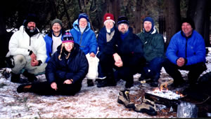
Michael Neiger (Marquette, Mi),
Dennis Waite (Berrien Springs, Mi),
Gail Bosi (Midland, Mi),
Mary Powell (Flint, Mi),
Mary Ann Hayman (Sault Ste. Marie, Ontario),
Jay Hanks (Perry, Mi),
Chris Ozminski (Attica, Mi), and
Dave Mansfield (Davison, Mi)
enjoy their remote bivouac
on the Pigeon River's
seldom visited Beaver Dam Island.
(Photo courtesy of Gail Staisil)View Gail Staisil's
photo album from this tripView Dennis Waite's
photo album from this trip
Though there was a couple of inches of snow on the ground the day was sunny and warm. Jay shot a "before" picture of the group against the mixed hardwood/evergreen forest.
In the first few hundred meters of walking I was reminded of one of the reasons that winter hiking is fun: the snow is like a time machine storing signs of the activities of all the wild residents of the forest.
In the blanket of white, tracks were everywhere. A deer had walked along the trail before us and had been joined by another....
There were coyote tracks of about the same age as the deer's--had they been following them? Squirrels and chipmunks had been busy too: Their tracks began and ended at tree trunks. Here and there were small excavations in the snow and the chewed remains of pinecones.
Mice had left a variety of signs: delicate individual tracks on the surface, mazes of tunnels and thoroughfares several inches wide where many small feet had packed the snow down.
There were many signs that the winter was still new: weed stalks were still filled with seeds and bushes with berries not yet eaten. Water, even in small streams, wasn't frozen and the brown leaves of the ferns hadn't been flattened by the snow.
Wintergreen showed through the snow, its green leaves and red berries a reminder of the coming holiday season. My mind wandered to thoughts of Christmas shopping...
To the swamp for lunch...
We hadn't been on the trail long when Michael decided we need a bit of diversion. "How about having lunch on an island in a swamp?" he asked, perusing the topo map.
"How far in the swamp?" Mary Ann queried. "Will we be needing stream crossing footgear?"
"Can't tell from the map," he replied. "We'll have to go look--but it shouldn't be real wet at this time of year."
Having been knee deep or more in a number of places that weren't supposed to be "real wet" we had some reservations, but map and compass work is always fun regardless of where it leads. Michael spent some time instructing those who were interested in the method for calculating an azimuth. Then we started of in the chosen direction.
After going a little way, on a barely existent two-track in the middle of nowhere, we encountered a pickup with an Otsego County Fire Dept sign on the door.
One of the occupants jokingly asked if we'd seen any fires. Michael chatted with them a bit about the condition of some other two tracks that were somewhat equivocal on the map and then we went on toward lunch.
Getting to the high ground in the swamp didn't require any major water crossings and the spot we'd aimed for turned out to be pleasant though not spectacular.
A cabin in the woods
By the time we finished eating, the position of the sun said that we needed to keep moving if we were to reach our planned bivouac before dark.
We bushwhacked to a road and followed it. After a while, Jay began to feel it was familiar and it soon became apparent that it led to the cabin of a friend of his, Dan Sullivan.
We arrived at Dan's driveway just as he was leaving to pick up a load of wood. Some of us accepted his invitation to fill our water bottles as it would save making another stop and accessibility of water at the proposed campsite wasn't certain.
The cabin was lovely--a study in rustic comfort: polished logs, many windows, all the amenities, neat, orderly, and warmed by a woodstove...We filled our bottles, chatted a bit and then went on.
Crossing the line
We followed the road past the private land, Michael demonstrated figuring an azimuth again, and Dennis led us off along a beautiful open ridge toward the Black River.
We came upon the river near the end of Green Timbers Road. We found the area where we planned to camp protected from ORV traffic by fortifications, which Jay described as "worthy of the Maginot Line."
Excavations backed up by posts reinforced with metal rods were further backed up by additional excavations. None of this was difficult to circumvent on foot, of course, but it did make us wonder if there was something back there besides the river and a nice, but not really outstanding, place to camp.
If there was, we never found it: that's our story and we're sticking to it....
Moonlight and warm bread
We each selected a bit of real estate to camp on. Some set up shelters; others just settled their things and began cooking dinner.
The almost-full moon rose as the sun set so it never got totally dark. The sky changed from oranges and reds to lavender and purple and then to deep blue. The brighter stars came out to accompany the moon. Thin clouds were backlit by its light.
As we waited for our pots to boil, we heard the sound of a distant truck muffled by the trees. Seconds later the engine cut off.
Soon there was some rustling in the brush nearby and Jay's friend Dan appeared in the firelight bearing gifts--bread still warm from the oven and an ample supply of fresh water. He settled in to visit and told stories of the area including some about the local ranger responsible for the fortifications we were camped behind--apparently a real life Barney Fife.
When Dan departed for his cabin "to cook up some ribs and cut some wood", I slid into my sleeping bag to relax and contemplate the night sky.
The meeting
The next morning we tried to get started a little early as we were supposed to meet the rest of the group at 10 a.m. at Round Lake, which was several kilometers away from where we were. We had a choice: to follow a rather circuitous road or bushwhack a somewhat shorter distance over unknown, but not-too-threatening, terrain on our quad.
We decided upon the latter despite the fact that such shortcuts sometimes aren't shorter time-wise. However, this time we were lucky--the terrain was pretty reasonable (just one small swamp) and our azimuth landed us right at the edge of the Round Lake campground.
We soon found that Gail, Chris and Dave had become acquainted, having found each other among the deserted campsites. After greetings and introductions, Michael and Gail shuttled her car to where we thought we might be on Sunday afternoon when she had to leave.
The rest of us hiked the NCT to the Pigeon River campground where we rejoined Michael and Gail for a rather chilly lunch.
The temperature continued to drop as we hiked in a generally northerly direction toward our planned bivouac on a small island we'd discovered on a previous trip.
An idyllic island
We found it in the late afternoon right where we'd left it--still covered with stately cedars for shelter and close by the soothing sound of running water. Again, we each found our place and assembled our things to spend the night. One of the priorities was to get into some insulation as this night promised to be colder than the last.
The culinary experiment for the evening was pizza which ended up being a bit on the charred side as the only wood readily available was cedar, which burns rapidly and very hot, and produces little in the way of coals.
It was a chilly but beautiful evening with the moon intermittently illuminating the rapidly flowing water and making shadows beneath the trees.
At one point, we heard some sounds across the river and we voiced the hope that it was Dan coming to visit again with more hot bread..... but that didn't happen and we never really came up with an explanation for the strange thumping noise.
We talked and Michael explained in detail the plans for upcoming snowshoe trips. When the fire died down, we moved to our bags and slept.
One bushwhack after another
When I opened my eyes in the morning, the first thing I noticed was that the water in my bottle was frozen.
Peering over the river bank, I saw a shelf of ice there too. Brrr.... I probably shouldn't have been surprised--it WAS December, but that doesn't make it any easier to leave the comfort of the sleeping bag.
I got up, gathered more cedar and built a handwarming fire on my elevated firepan before stuffing the cold nylon bag.
We took our time with breakfast and it was midmorning before we got back on the trail, which we followed to the Grass Lake overlook. We took a break there to enjoy the view then embarked on some map and compass practice.
Chris led us on a three-legged bushwhack, first north and then west, to another point that overlooked a forested valley. We took in the view there too and enjoyed the sense of accomplishment that comes with ending up where you wanted to be off trail.
We then dropped down to a field where we had lunch with a broad view of a snowy grassland.
After lunch Jay took a turn leading on an 1800 meter bushwhack across a series of fields that had been clear-cut and/or plowed in the recent past. Despite little overall change of elevation it was a fairly strenuous bit of walking because of the uneven ground.
This bushwhack ended at a road that we followed to an intersection where Gail had to part company with the group and follow the road to her car--always a hard thing to do....
Water and a place to sleep
The next project for the group was to pick up additional water or find a spot on the Pigeon River nearby to camp.
We followed the road we were on for a while then struck off north along an old railroad grade that would intersect the river. The intersection of the grade and the river did not pan out as a place to camp as there was little flat sheltered ground near the water.
Michael chopped a hole in the ice where some filled their bottles while others ventured aside to find open spots to dip from.
Leaving the river we followed the county line west then turned south to hit a hill on the map that appeared to overlook an open area. We found the hill without much difficulty but the field below looked more inviting and we ended up choosing to camp in some pines not far from its edge.
Jay found a pine with a particularly sheltered spot that was cushioned with needles beneath its branches. The rest of us chose spots nearby and set up shelters or started the evening meal.
Conversation wandered over many subjects. Dennis told a number of stories about his dogs, past and present, and about getting into dogsledding. Everyone shared stories or recollections of past wilderness adventures.
Things get a little fuzzy
It wasn't as cold as the previous night and the bright moon on the snow was an invitation to take a walk--so I did.
I hadn't gone far when I discovered that I'd lost a lens from my glasses. About the same time I ran into Michael returning from a bit of exploring of his own.
We retraced my steps searching for the lens and everyone helped me to look back at camp, but finding a plastic lens in the snow in the moonlight is probably even less likely than finding a needle in a haystack.
The rest of the trip would just have to be a little out of focus.
More map and compass
Morning dawned gray but not unpleasant. We lingered a bit over breakfast but everyone had a drive at the end of the hike so we didn't dally too long.
Michael designated a three person team to figure out how to get to our first objective to give them a little map and compass practice.
We wanted to visit the honeymoon cabin at Green Timbers, which lay a little south and west of our bivouac. There didn't appear to be any obstacles in between and a north-south ridge provided a nice catching feature so we just started off across the plain in a direction just a bit south of west and planned to turn south when we hit the ridge.
Another rustic cabin
This plan worked well and by midmorning we were having a snack and enjoying the view from the cabin, which was unoccupied but still had warm coals in the fireplace. This state-owned log cabin, which has a panoramic view of the Sturgeon River valley below, is open to the public on a first-come, first-serve basis.
The river and the trail's end
After taking in the cabin we dropped down into the valley, picking up the hiking trail that would take us along the river to the bridge. The hardwood forest of the ridge gave way to the swamp and grassland that the Sturgeon River winds through.
When we came to the bridge we paused for photos and Jay, being a paddler, looked longingly at the water as if willing a canoe to appear.
We were still a couple of kilometers from the cars and another designated nav team came up with a plan to get there. We would be walking through a branching series of old two-tracks watching our direction and the terrain to decide which to follow.
We couldn't go too far wrong as we had Fontinalis Road where the cars were parked to keep us from getting past them to the west. The team did well (or got lucky) and we ended up walking right to the elk viewing area where the cars were parked.
We loaded our gear and said our farewells to those who were leaving directly.
The rest of the group went to pick up the cars parked in other places and meet for a post-trip lunch at a small restaurant in Vanderbilt.
There we talked about the highlights of the trip and our plans for the next one...
______________
View Gail Staisil's photo album from this trip.
View Dennis Waite's photo album from this trip.
Read another photo-journal.
Return to TheRuckSack home page
In God's wilderness lies the
hope of the world,
the great, fresh, unblighted, unredeemed wilderness.
— John Muir 1838-1914, Alaska Wilderness, 1890
Content Copyright © 1984-2004 by Michael A. Neiger
All rights reserved. Comments? Suggestions?
Dead links? Inaccurate info?
Contact the WebMaster at mneiger@hotmail.com
A MacroMedia DreamWeaver 4 and Fireworks 4 production