TheRuckSack > photo-journal archive index > archive page
Wilderness Tripping:
Backpacking
Mackinac Wilderness
& North Country Trail
Mackinac and Chippewa Counties
Trout Lake, Michigan
October 31 thru November 3, 2003
Exploring the
North Country Trail,
Mackinac Wilderness Tract,
and Hiawatha National Forest
By Gail Staisil
Midland, Michigan
Copyright 2003
E-mail author at woodswoman2001@yahoo.com
View Gail Staisil's photo album from this trip
Return to photo-journal archive index page
Return to TheRuckSack home page
Thursday October 30 - Pre-Trip
It was a beautiful sunny day when I left Midland to drive up to the Upper Peninsula. Today's journey would only take me to the Eastern U.P., a distance of about 200 miles. The destination would be the Trout Lake area. It is there that we would converge to start our backpacking trip tomorrow. Of course, I had to make my trip longer...
Heavy clouds hung over the northern terminus of the Mackinac Bridge. The weather forecast that was predicted was about to materialize.
I had in mind that I would spend the afternoon exploring the Tahquamenon Falls area. It had been about twenty years since my last visit. I could barely remember details of that trip. Rain set in but I was determined to go anyway.
I arrived at the Lower Falls to an empty parking lot. I suppose 42 degrees and rain keeps the throngs of tourists away that usually visit. I was in luck and had the attraction to myself. I walked to the various overlooks and then headed to the Upper Falls by car. It is a mere eight mile round trip hike but I knew that my timing wasn't in the cards as it was already 3:30 PM, only two hours before sunset. I will plan to hike it next time but hopefully another twenty years will not go by. :)
I did enjoy taking a few shorter trails for a quick walk through the forest. Upon leaving, I decided to take the Lakeshore Road east instead of heading back south on M-123. I arrived in Strongs, looking for a place to spend the night. It wasn't exactly prime time there, so most places were closed up tight...it would be a few weeks before the deer hunters and snowmobilers arrived. I found a small motel for a thirty dollar fee and to my delight, it was immaculate and decorated tastefully. It was owned by Handy Andy and Cow Patty, very personable operators of the Clark Motel.
Friday October 31 - Exploring the Mackinac Tract
I met the rest of the group for breakfast at McGowan's
Restaurant in Trout Lake. They included Michael, Mary, Dan, Mary Ann and
Jay. Jay already knew several members of the group as he leads paddling
trips year round. I had often heard of his advanced skills and journeys
so I had no doubt that he would be a fine addition to this trip.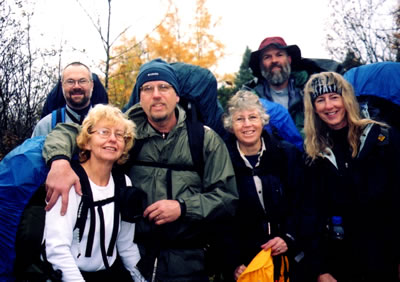
Jay Hanks (Perry, Michigan), Mary Powell (Flint, Michigan), Dan Soper (Flint, Michigan) Many Ann Hayman (Sault Ste. Marie, Ontario), Michael Neiger (Marquette, Michigan), and Gail Staisil (Midland, Michigan) enjoying the Hiawatha National Forest. (Photo courtesy of Gail Staisil)
View Gail Staisil's
photo album from this trip
We began to shuttle cars. Michael and I left our vehicles near the Carp River Bridge on East Lake Rd. while the others left their vehicles well north of H40 and Biscuit Creek.
It was a dreary day but the rain was on the light side and would soon dissipate.
Our start point would be near the Carp River in the Mackinac Wilderness Tract. We took an overgrown trail near the river, which later actually turned into an old camouflaged roadbed.
Soon after we started, we approached the Spring Lake Creek area. Much of the area was flooded and I quickly got my feet soaked when crossing the first beaver dam. The dam was low lying so it didn't provide a real dry endeavor.
We stopped for a break on a nice ridge overlooking the river. Of course the paddlers in the group already were speculating how this river would be to paddle. Every time we are on a trip, we dream of future places to come back to...we have really long lists!
We crossed the North Branch of the Carp River. We had to don sandals as it was much deeper than the last time some of us were in the area. Much of the trail peters out after this crossing. We had to look for evidence of the old roadbed.
We crossed another beaver dam, this one being rather lengthy. It took some time to work our way across, pushing invasive vegetation out of the way. We had lunch shortly afterward.
The old road bed was often hard to follow. We eventually picked up a spur that started off in fine shape but eventually was flooded in many areas. From this roadbed, we headed due north through the bush to bivy for the night along Taylor Creek.
It was almost sunset so we set up quickly to utilize the remaining light. We heard coyotes yelping as we were eating dinner and again later in the evening.
Mary set up her fire pan and had a small fire. It was handy to start drying my boots, socks and gloves that were rain soaked from today. I had been leading the group all day through the water soaked vegetation so I got quite wet. Even though I had dry clothing in my pack, this was day one and it was best if I could dry some of this gear.
Saturday November 1 - Creek Crossings and Glacial Erratics
It had been a very peaceful night, very quiet. The wind did pick up a little but quickly settled down to stillness.
I decided to eat my breakfast right in the entryway of my tarp tent. I had an excellent view of the river since I was located on a small ridge above it.
We headed out on the ridge following the creek. Jay quickly picked up a hunter's path that was marked with reflective dots. We joked about the differences between reflective, iridescent and fluorescent, we decided that the dots were reflective.
We soon located evidence of branch removal and the hunting blind itself. We speculated whether it was from bear hunters or deer hunters...then we found the bear bait hole that they usually fill with molasses. We were able to follow this path all the way to the pipeline, as it was heading in the direction we needed...sometimes we are lucky.
We emerged onto the pipeline where we now had to cross two creeks--Taylor and Bissel Creeks. The former looked more like a river as it was quite swollen by rain and beaver activity. We speculated that we might be getting wetter than planned. Michael led the way and found a good route without getting any clothing wet.
The first crossing went fine and the next was a mere one quarter mile away. My feet were absolutely frozen from the first crossing but I didn't want to change back to my boots for such a short distance. It's a good thing I didn't because the territory between the two creeks quickly deteriorated into a very wet swamp. It was a lengthy total foot and shin immersion through icy waters. We used a beaver dam at one point and then found an actual crude ladder-like footbridge at Bissel Creek. By then, the arches of my feet were cramped and frozen in a board-like condition. I slowly crossed with the fear of toppling into the water... I was very relieved to get to the other side.
We all quickly dried our feet and legs and changed back to boots. We followed the pipeline for a bit but then headed cross-country to find a section of the North Country Trail. This would allow us to use a footbridge rather than having to ford the North Branch of the Carp River again. We ran the NCT for a few klicks and then bushwhacked north to an old road bed. The NCT section we utilized was very rocky and rugged with lots of huge glacial erratics.
Erratics are huge boulders that were transported a great distance and deposited by glacial activity. As the ice moved it froze around these boulders and left them where they are now. We bushwhacked north from the NCT to an old road bed. We later took forest road 3327 north on the west side of East Lake. We bivied south of the East Branch of the North Branch of the Carp River.
Although it wasn't quite dark when we settled in, the remaining light disappeared quickly. It's always hard to decide what has priority first--setting up the shelter, hanging the bear rope or getting your water supply. All of these lead to challenges in the dark. On this day, I left the bear rope hang until last and I had to make more throws than I wanted, to get it in the right spot.
The half moon showed occasionally through the clouds but became obscured by the time I retired. It was an extremely quiet night. My candle had burned straight up with no perceptible wind.
Sunday November 2 - The "Upland" Swamp
Got up around 7 AM. After breakfast, Mary, Michael and I did a quick recon to East Lake. We had been awakened with the early morning sounds of gunshots. Duck hunters were busy on the nearby East Lake. We peered out into the lake and sighted several islands that were close by.
When we got back to camp, the others were ready to go. Our first mission this morning would be to find a spot to cross the nearby river branch. It wasn't very wide but deep enough for full boot immersion. Michael located a spot downriver that had a large rock in the center. It was still quite a stretch for some of us with fully loaded packs. Michael hopped across and offered a helping hand.
We headed into the forest and pursued a relatively easy bushwhack through hardwoods. It is so much easier to travel through hardwoods with the lack of a dense understory.
We followed an old road bed for awhile and then bushwhacked through to a lightly traveled bush road. After taking a break, we headed into the bush for what we thought would be a simple one klick bushwhack.
It was very harsh country and by the time we finished we had been working three and one half hours including our lunch break. We were skirting the worst of the swamp--Michael penned it "upland" swamp. It was a very dense cedar forest, lots of sphagnum moss, wet holes and seemingly impenetrable brush. I seemed to get hung up constantly on sticks and tree branches.
On the other hand, the cedar swamp had many redeeming qualities. The colors of the vegetation were intense, the beautiful greens of the sphagnum, the small patches of reds, and the golden cedars fragments that had shed and fallen onto the ground made for an amazing visual.
We were now in the vicinity of the ridge above Schlehuber's Marsh. It has several contour lines so we were anxious to check it out. The ridge lines ran for at least a click and a half, this could be really nice...and it was! We checked out many of the views and had a hard time deciding if we wanted to bivy on the ridge or down below on the edge of the marsh.
Schlehuber's Marsh was a mere shadow of what it used to be. The edge of the water line was greatly receded compared to the topo map and now there were huge mud flats in many areas. Marshes are greatly cyclical in nature.
We chose to stay at the marsh edge. It would allow Mary to have a fire pan blaze with a water supply nearby. Dan and Mary Ann both had new tarps so they experimented with a different configuration.
The evening was very pleasant--still no decipherable wind. Michael found a spot to read above us on a small ridge. Dan fell asleep shortly after dinner and the rest of us chatted with Mary who was tending her fire.
Jay told us of his adventures and we talked about the day in the swamp. Jay remarked that "There is a fine line between recreation and suffering." Some of these pursuits we undertake are not easy but leave us with good feelings of successfully exploring the unconventional.
The half moon played games all evening, it could not be seen unobscured for more than ten seconds at a time. Coyotes howled in the distance, we hoped they would come in closer...at least most of us did!
Around 9 PM, the clouds began to break-up and all sorts of amazing patterns were evident. Juniper and the half moon could now be seen more readily. I watched the sky for a long time before I drifted off to sleep.
Pre-dawn, the skies were clear and the stars were brilliant. A chorus of coyotes could be heard, I laid in my sleeping bag watching the morning begin.
Monday November 3 - Ridges and Trains :)
It was a bit chillier this morning, it was below freezing as there was some frost on my tarp and ice in my water bottles.
Today we would retrace our steps across the marsh and then go back up the ridge. We would traverse the later as part of our plan. These ridges look to be very untraveled at best, no signs of human impact.
We followed the length of the main ridge and then headed north for a lengthy bushwhack. We headed through areas of pine forests and later hardwood forests making sure we skirted two sections of private property. We would aim directly in the middle of them on state land.
Traveling through the pine areas was a little slower as the lower dead branches offered resistance as you walked through. The crackle of these branches punctuates the air. I thought a polycarbonate face shield would come in handy. :)
We reached H40 and traveled east along the shoulder for 1600 meters. The vegetation that skirted the road was dense cedar and swamp territory. We would find a better place to head north again. When we gained some elevation, we found a mostly pine forest to head north through to the railroad tracks. The last part was dense cedar forest again.
When we got to the tracks, it was our lunchtime. We quickly found a comfortable spot near the tracks with some of the group settling on a huge pile of railroad ties. No sooner than we started lunch, Michael thought he heard the distant rumblings of a train. After about ten minutes it became clear that it really was a train and not truck traffic sounds from the nearby H40. We relocated our gear further back from the tracks in the trenches to protect it from the wind of the train. It was a lengthy train with many Canadian Pacific cars.
After viewing the train, Michael remarked, "The worst weather we had on this trip was from the wind produced by the train." He was so right!
Things were about to change. We finished lunch and the first snowflakes began to fall. As we headed down the tracks, the snow increased in intensity. Most of us donned our Gore-Tex or other waterproof gear as it was rather wet.
We left the tracks after a short distance and bushwhacked in a northerly direction again through a gorgeous forest. The late fall colors were so intense--the russets, yellows and greens of the conifers made for a nice contrast. We now came to a two track which was located a short distance from our final destination.
We reluctantly ended the trip, four days seemed way too short. We shuttled cars and met back at McGowan's for a late afternoon lunch. We reminisced about our journey and where our future travel will take us. It was nice to be with old friends and new friends, all enjoying the pursuits in the outdoors.
View Gail Staisil's photo album from this trip.
Read another photo-journal.
Return to TheRuckSack home page
In God's wilderness lies the
hope of the world,
the great, fresh, unblighted, unredeemed wilderness.
— John Muir 1838-1914, Alaska Wilderness, 1890
Content Copyright © 1984-2003 by Michael A. Neiger
All rights reserved. Comments? Suggestions?
Dead links? Inaccurate info?
Contact the WebMaster at mneiger@hotmail.com
A MacroMedia DreamWeaver 4 and Fireworks 4 production