Location: TheRuckSack home page > upcoming trips page > trip page
Sierra Club Wilderness
trips and expeditions
Chapter: Michigan (Mackinac)
Group: Central Upper Peninsula (CUPG)
Leader: Michael Neiger, Marquette,
Michigan (Web site; e-mail;
bio)
February
18-26, 2006
19th
Annual Canadian Snowshoe Expedition
9-day, minimum 40-kilometer sledge
This year's signature, expert-level, winter-camping trip--our 19th Annual Canadian Snowshoe Expedition--will involve a nine-day, 40-kilometer snowshoe tour pulling expedition-size cargo sledges, much as the Ojibwa traveled for 100s of years before us.
This trip will represent a second attempt to successfully sledge completely through the heart of Lake Superior Provincial Park. A similar, 1992 attempt--the Wizard Creek Expedition--failed due to exhausting conditions: extremely deep powder snow. If we are successful at penetrating the park's bush, we will explore the upper reaches of the Sand River Valley, including the northern portions of the old Algoma Snowshoe Trail that was popular in the 1940s and 1950s. If time and conditions permit, we will also recon the old Sand River Fire Tower that is situated northwest of Sand Lake, north of the park.
Having spotted vehicles at Frater Road along Highway 17, mid-morning on Saturday, we'll begin a 35-kilometer, 8-day eastward sledge through the park. We'll sledge up to and across Gamitagama Lake, down the Anjigami River, across Mijinemungshing Lake and out its North Arm, up Maquon Creek and across Maquon Lake, overland and down to an unnamed tributary of the Sand River, down this tributary to the Sand River, and up the Sand River to Sand Lake, where we must flag down the southbound No. 632 Train on the Algoma Central Railway tracks near Mile 136, the following Saturday, just after lunch.
Once aboard this historic bush train, we will relax in a rugged box car with our sledges, or in a heated passenger car where beverages and snacks are served, as the train rumbles through the magnificent Agawa Canyon. We'll have the conductor drop us and our sledges at the original Frater Station near mile 104, where we will begin a 5-kilometer sledge, first through the bush, and then down along the unplowed Frater Road, bivouacking as needed, to arrive at our vehicles at Highway 17 midmorning on Sunday.
As we sledge over the height of land just east of Maquon Lake and begin our descent into the Sand River Valley, our point person will be keeping an eye peeled for aerial spoor--high blazes--marking remnants of the old Algoma Snowshoe Trail, which was first blazed in 1943 by members of The Snowshoe Club. Also known as the Sand River Snowshoe Trail, this network of frozen waterways and overland foot trails was marked with high blazes so it could be followed when carpeted with six feet of snow.
Founded in 1932, The Snowshoe Club developed remote winter trails, first along the Montreal River and later along the Sand River. Plans called for connecting these two sections of trails to create about 150 miles of winter snowshoing paths. According to the club's president, Les Perrine, who was known as The Snowshoe Man, the Algoma Snowshoe Trail was "modeled somewhat after the Appalachin [sic] Trail."
In a 1966 letter written to MNR Rangers in Wawa, Ontario, The Snowshoe Man said "the Snowshoe Trail is designed and built primarily to be a winter trail thru sub arctic mountain wilderness areas." He wrote that they "could not fore tell at the start the wide extent of activities the club and the trail would cover nor the widespread publicity the trail would receive. Nor that it would become a means of sub arctic research producing much valuable information for U.S. and Canadian Air Force, Civil Defense, Boy Scouts, conservation, and teaching."
The Snowshoe Man went on to write that their club consisted of 1200 members and that their Snowshoe Trail and Cabins had been the topic of over 100 stories or presentations by newspapers, magazines, radio stations, TV stations, and club members.
The Sand River Snowshoe Trail system also included four small, rustic wood cabins known as Cabin No. 1, No. 2, No. 3, and No. 4. It is very possible that these cabins remain to this day as they were well-constructed and the three I visited in the early 80's were still intact.
Cabin No. 1, located along the north shore of Sand Lake, opposite Mile 136 on the ACR Tracks, was built in 1949. Cabin No. 2 was built in 1950 along the west bank of the Sand River, between portage No. 3 and No. 4, and it served as the group's headquarters. Cabin No. 3 was built along the east bank of the Sand River, about 0.5 miles downstream of Portage No. 7. Cabin No. 4 was built in 1954 along the south shore of White Spruce Lake, near the outlet in the small bay. Known as Buckingham Palace, it was reportedly "the pride of the club."
All of the cabins rested atop 7-foot high stilts so they were accessible in deep snow and inaccessible to bears, which were always a problem. Each cabin was heated by a tiny sheet metal stove and included a porch, shutters, bunks, and a ladder for access. A food cache on stilts was usually located near by. The cabins were generally no larger than 10.5 feet in length and 5.5 feet in width so they could be easily heated: "The sleeper can start the morning fire while still in the sleeping bag. In 15 minutes the cabin is warm even when 40 below zero outside." Hand-built from split cedar shakes, the cabins were stocked with "food, supplies, and equipment."
Closed in the winter and only open to muscle-powered activities when it is open, the nearly trailless Lake Superior Provincial Park is free of snowmobiles, ATV's and float/ski planes. Our only company will likely be the hearty timber wolf, the mighty moose, and Mother Nature, who on past expeditions has greeted us with arctic-like weather conditions: standing temperatures as low minus 50 degrees F and snow depths to 6 feet.
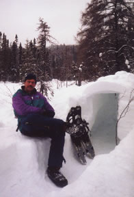
Gary De Kock prepares
a snowshelter in anticipation
of a 40-below night
along the Little Agawa River,
deep in the Canadian bush,
February 2001
(Photo by Michael Neiger)
Destination:
Lake Superior
Provincial Park,
Algoma District
South of Wawa, Ontario
Experience level:
Expert-level,
minus 50 degree wintercamping
Requires prior, long-range,
winter-camping experience with leader
Difficulty:
Extremely strenuous
Only suitable for the expeditioner in peak physical
condition
Off-trail/on-trail rating:
100 percent off-trail
map & compass recon
Participant requirements:
-- Notice:
please review the homepage on this Web site
for general wilderness tripping requirements
-- 18 years old or older
-- non-smoker and non-drinker
-- very physically fit (good aerobic endurance)
-- adventurous spirit
-- proficient swimmer
-- prior wilderness tripping experience
-- fully equipped with lightweight backpacking gear
including rucksack, bivouac gear,
survival gear,
foul-weather gear, rations, stove,
etc.
Bivouac
advisory:
This
is not a basecamp trip.
We will move each day
and bivouac in a different location each night,
often deep in the bush and far from roads,
dry & level campsites, potable water, toilets, and
fire rings.
Expect temperatures
to dip to minus 40 or 50 F
and snow depths to exceed 4 or 5 feet.
Trip info:
-- 10 a.m. Saturday
to noon on Sunday
-- Club fee: $20
-- Rental of club sledge: $5
-- Park permits: None, LSPP is closed during the winter
-- Train fees: $24 Canadian ($29 on trian) 2005 prices
-- Sign up
by January 27 required
-- Contact trip
leader to sign up, or for application form if new
-- Review journals
and photos from similar wilderness trips
Specialized equipment required:
-- In-pocket survival
kit (knife, matches, firestarters,
compass, whistle); Sierra Club survival
kits can be
borrowed free of charge
-- Expedition-size
sledge (five, first-come,
first-serve,
$5-rental club sledges available by
prior arrangement)
-- Ice-rescue picks
Rations required:
-- Breakfasts--8
-- Snacks--9
-- Lunches--9
-- Dinners--8
-- Backup rations--2 full days
-- Rations and stoves info
Additional destination info:
-- Algoma Central
Railway, 1-800-242-9287, http://www.algomacentralrailway.com
-- Lake Superior Provincial Park headquarters, 1-705-856-2284,
http://www.mnr.gov.on.ca/MNR/parks/lakes.html
-- "Railpacking," by Don Stap, Backpacker
Magazine, September 1985, pp. 48-49.
-- Backpacking and Wilderness Camp Site Areas in
Algoma Central Country, undated 3-page photocopy by Algoma Central
Railway.
-- Canoe Routes, Lake Superior Provincial Park
brochure, 2000 edition
-- Hiking Trails, Lake Superior Provincial Park
brochure, 2001 edition
-- The Complete Guide to Walking in Canada, by
Elliott Katz (Firefly Press, 2001)
-- Exploring Superior Country--The Nature Guide to
Lake Superior by Craig Charles (1992, NorthWood Press, Inc.)
-- Voyageur Hiking Trail Guidebook, (Voyageur
Trail Association, 1998)
-- Agawa Ice Climbing Map, (Granite Publishing,
1999) http://www.climbingcentral.com
-- Algoma Central Railway, by O. S. Nock (A.
C. Black Limited, 1975)
-- Tracks of the Black Bear, by Dale Wilson and
Gordon D. Jomini (Nick Belt Rails, 1990)
-- The Algoma Central Railway Story, by Dale
Wilson (Nick Belt Rails, 1984)
-- Forest Trails: Mile by Mile, by Rick Vosper
(Algoma Central Railway, 2002)
-- Ice Climbs of the Lake Superior Region--A Compendium,
edited by Don Hynek (Granite Publishing, 2000) [Agawa Canyon and Montreal
River Gorge, pp. 133-172]
-- Guide to Sea Kayaking on Lakes Superior and Michigan:
The Best Day Trips and Tours, by Bill Newman, Sarah Ohmann, and Don
Dimond (Globe Pequot Press, 1999) [Lake Superior Provincial Park, pp.
174-181]
-- Search
destination in http://www.google.com
search engine
Travel
info:
-- Driving maps
-- Road conditions and weather
reports
-- Tourism info
-- Road trip gear
Wilderness skills and resources info:
-- Backpacking
skills
-- Land nav skills
-- River fording skills
-- Water purification
skills
-- Lightning safety
-- Low-impact skills
-- Backpacking links,
books, & vendors
-- Ultralight backpacking
links, books, & vendors
--
Dressing warm skills
-- Sleeping warm skills
-- Winter-camping skills
-- Ice-crossing skills
-- Snowshoe links,
books, & vendors
-- Winter-camping
links, books, & vendors
Emergency contacts:
-- Ontario Provincial
Police, Wawa, 1-888-310-1122
-- Ambulance, Wawa, 705-856-4203
-- Hospital, Wawa, 705-856-2335
-- LSPP Red Rock Lake Headquarters, 705-856-2284
-- Algoma Central Railway, 1-800-242-9287
-- Sierra Club Outings Department 24-hour help line:
1-888-outings
Land Nav Team Info:
Topographic maps (required):
1:50,000 Old Woman Lake 41N/10 & 41N/11
(main route)
1:50,000 Agawa Bay 41N/7 (Frater Road route)
Topographic maps (optional):
1:50,000 Michipicoten Harbour 41N/15 (upper
Sand Lake)
1:20,000 20-16-6600-52800 (main route)
1:20,000 20-16-6700-52800 (main route)
1:20,000 20-16-6800-52800 (main route)
1:20,000 20-16-6800-52900 (upper Sand
Lake; fire tower)
1:20,000 20-16-6800-52400 (Agawa Falls;
Frater Road)
1:20,000 20-16-6700-52400 (1-klick
portion of Frater Road)
1:20,000 20-16-6600-52900 (alternate
north route)
1:20,000 20-16-6700-52900 (alternate
north route)
1:20,000 20-16-6600-52700 (alternative
south route)
1:20,000 20-16-6700-52700 (alternative
south route)
1:20,000 20-16-6800-52700 (alternative
south route)
--Topo map ordering
information
--Topo map waterproofing
& GPS prep
Provincial Park map (recommended):
1:100,000
Lake Superior Provincial Park Map
--Order from Provincial Park at 1-705-856-2284
2006
magnetic declination specs:
Magnetic declination
for Lat 47° 43'N, Lon 84°37'W:
07° 31' west
UTM easting grid line to meridian
line deviation:
01° 40' east
UTM easting grid line magnetic declination:
09° 11' west
GPS
configuration specs:
Grid coordinate
system
1000-meter Universal
Transverse Mercator Grid (UTM)
UTM grid horizontal map datum:
1:20,000 maps:
1927
North American Datum Canada (NAD 27 Can)
1:50,000 edition 2 (old) maps:
1927
North American Datum Canada (NAD 27 Can)
1:50,000 edition 3 (current)
maps:
1983
North American Datum (NAD 83)
UTM grid zone:
Zone 16
UTM grid hemisphere:
Northern hemisphere
Unit of measure:
Metric
Battery type:
Lithium, for deep
cold, or long-range use
Alkaline, for 3-season
use
Battery type setting:
Select type of battery
(lithium, alkaline, or Ni-Cad);
battery discharge-rate
differences affect meter accuracy
Misc nav setup:
Roamer
UTM plotter scale(s):
1:20,000 & 1:50,000
Ranger pacing
beads:
Metric--9 100-meter
beads; 4 1-kilometer beads
Magnetic declination setting on compass:
0° of offset
More land nav team info
Return to upcoming trips page and read about another trip