 |
You're here: Extreme Trail Maps home page :: Exploring Pictured Rocks book
|
|
|
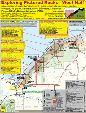
The definitive bush guide to the west half of Pictured Rocks National Lakeshore, which is located along Lake Superior's south shore in the Upper Peninsula of Michigan, just east of Munising, Michigan...
Exploring Pictured Rocks—
West Half
A backpacker's & spelunker's backcountry guide to the trails, campsites, beaches, overlooks, old growth, waterfalls,
caves, shipwrecks, & history of
Pictured Rocks National Lakeshore
|
|
| |
|
Book beta |
| Author: |
|
Michael Neiger |
| ISBN 10: |
|
0-942057-01-0 |
| ISBN 13: |
|
978-0-942057-01-0 |
| Publication date: |
|
2013 |
| Copyright date: |
|
2013 |
| Edition: |
|
First |
| Number of pages: |
|
36 |
| Language: |
|
English |
| Format: |
|
Paperback |
| Binding: |
|
Saddle stitch, staple |
| Cover: |
|
Full color on heavy 13-point, matte-finish paper |
| Inside: |
|
Full color on heavy 100-pound, gloss-finish paper |
| Size closed: |
|
8.5" wide by 11" high |
| Size opened: |
|
17" wide by 11" high |
| Number of USGS topographic maps: |
|
13, full color |
| Number of detailed map illustrations: |
|
24, full color |
| Number of detailed elevation profile illustrations: |
|
12, full color |
| Suggested retail price: |
|
$19.95 (US) |
| |
|
|
|
| |
|
USGS quadrangle beta |
| Source: |
|
U.S. Geological Survey |
| Scale: |
|
1:24,000 |
| Type: |
|
Full color |
| Contour interval: |
|
3 meters |
| Coordinate system: |
|
Universal Traverse Mercator (UTM) |
| Coordinate grid: |
|
1,000-meter UTM |
| Map datum: |
|
North American Datum (NAD) of 1927 |
| Quadrangle names: |
|
Grand Portal Point, Michigan 1983
Indian Town, Michigan 1984
Melstrand, Michigan 1983
Munising, Michigan 1985
Trappers Lake, Michigan 1983
Wood Island SE, Michigan 1984 |
| |
|
|
|
| |
|
Walk-in retail sales |
 |
|
Book World, Inc.
136 W. Washington Street
Marquette, Michigan 49855
1-906-228-9490 |
 |
|
Down Wind Sports
514 North Third Street
Marquette, Michigan 49855
1-906-226-7112 |
 |
|
Falling Rock Café and Bookstore
104 East Munising Avenue
Munising, Michigan 49862
1-906-387-3008 |
 |
|
The Gift Station
101 Cedar Street
Munising, Michigan 49862
1-906-387-3013
|
 |
|
Grand Island Ferry Service
P.O. Box 333,
Wetmore, Michigan 49895
N-8016 Grand Island Landing, Munising, Michigan 49862
1-906-387-3503 |
 |
|
The Melstrand Store
N-8501 County Road H-58
Shingleton, Michigan 49884
1-906-452-6070 |
 |
|
Munising Visitor Center, Kelly Marketing
109 West Superior Street
Munising, Michigan 49855
1-906-387-8310 |
|
|
Paddling Michigan, Uncle Ducky Outfitters
1331 West M-28
Munising, Michigan 49862
906-228-5447
|
 |
|
Pictured Rocks Cruises
100 City Park Drive
Box 355
Munising, Michigan 49862
1-906-387-2379 |
  |
|
Pictured Rocks National Lakeshore &
Hiawatha National Forest
Interagency Visitor Center
400 East Munising Avenue
Munising, Michigan 49862
1-906-387-3700
|
 |
|
Putvin Drug Store
119 Elm Avenue
Munising, Michigan 49862
1-906-387-2248 |
 |
|
Snowbound Books
118 N. Third Street
Marquette, Michigan 49855
1-906-228-4448 |
 |
|
Sports Rack Ltd
315 West Washington Street
Marquette, Michigan 49855
1-906-225-1766
|
 |
|
Switchback Gear Exchange
209 South Front Street
Marquette, Michigan 49855
1-906-362-4327
|
| |
|
|
|
| |
|
Phone-in mail-order retail sales |
 |
|
Snowbound Books
118 N. Third Street
Marquette, Michigan 49855
1-906-228-4448 |
| |
|
|
|
| |
|
Online mail-order retail sales |
 |
|
Amazon.com
1-866-216-1072
|
| |
|
|
|
| |
|
Phone-in wholesale orders |
 |
|
Extreme Trail Maps
Michael Neiger
313 Jonathan Carver Road
Marquette, Michigan 49855
1-906-226-9620
mneiger@hotmail.com |
 |
|
Partners Publishers Group
2325 Jarco Drive
Holt, Michigan 48842
1-517-694-3205 |
| |
|
|
|
| What others are saying about Exploring Grand Island |
| Exploring Grand Island is a work in progress and the author welcomes your comments, corrections, and ideas regarding how future editions of this backcountry map guide can be improved at mneiger@hotmail.com |
| Media reviews |
-
New Backcountry Guide To Pictured Rocks Released! Looking to put up some first ascents this winter? I just spent several hours on the couch checking out Michel Neiger’s latest work- Exploring Pictured Rocks West Side, which reveals hundreds of caves throughout the park and possible first ascents for those willing to explore. If your planning a trip to visit Pictured Rocks National Lakeshore anytime of the year, then this guide is a must! “Exploring Pictured Rocks” is an 8.5″ by 11″ full-color heavily-annotated map guide to the PRNL, which is located along the south shore of Lake Superior, near Munising, Michigan. The map guide relies on full-size, full-color, 1:24,000-scale, US Geological Survey quadrangles to show the location of trails, campsites, beaches, overlooks, old growth, waterfalls, historic sites, caves, & shipwrecks. Each feature is described according to name, dimension, physical distance from other features, GPS coordinates, elevation, etc. Historical info is also included. Developed by our friend Michael- who explored every inch of this park, this is the most detailed information on PRNL ever produced!
—Bill Thompson, Michigan Ice Fest Web Site, August 9, 2013
| |
 |
- New Guide to Pictured Rocks Released! I just spent several hours on the couch checking out Michel Neiger’s latest work- Exploring Pictured Rocks West Side. If your planning a trip to visit Pictured Rocks National Lakeshore then this guide is a must! “Exploring Pictured Rocks” is an 8.5″ by 11″ full-color heavily-annotated map guide to the PRNL, which is located along the south shore of Lake Superior, near Munising, Michigan. The map guide relies on full-size, full-color, 1:24,000-scale, US Geological Survey quadrangles to show the location of trails, campsites, beaches, overlooks, old growth, waterfalls, historic sites, caves, & shipwrecks. Each feature is described according to name, dimension, physical distance from other features, GPS coordinates, elevation, etc. Historical info is also included. Developed by our friend Michael- who explored every inch of this park, this is the most detailed information on PRNL ever produced! $19.95.
—Down Wind Sports, Marquette, Michigan, August 11, 2013
-
Second "Extreme Trails" Guide Now Available. The second in a series of highly detailed guide maps of local public areas is now available.
The new book, " Exploring Pictured Rocks—West Half," is the second in a series called "Extreme Maps for Extreme Trails," which is being created by outdoor adventurer Michael Neiger of Marquette. Neiger's first book highlighted the Grand Island National Recreation Area, and was released in August of last year. As the title implies, this
year's version covers the western half of Pictured Rocks National Lakeshore, from Munising Falls to the Beaver Lake area.
Like the previous version, the booklet features sturdy, glossy pages that include a wealth of information, including physical features of the park that the average trail hiker many not ever notice on his or her own. These features include the locations of caves, lesser-known waterfalls, old-growth trees, and even rocks features that many locals may not otherwise know about unless they have the habit of leaving the established trail.
As an experienced wilderness guide, Neiger has just that habit, and used his expertise to locate and chart the given features. But instead of simply wandering all over every square foot of the Pictured Rocks National Lakeshore to look for these features, he used history and logic to narrow his search. "I did some research to find out how these caves were formed. They're littoral caves, formed by wave action. Lake Superior (which formed these inland caves) was once much higher that it is, tens of thousands of years ago. Once I knew the elevations that the caves were formed at, I knew where to look for them. I walked those elevations...to look for cliff formations and caves," he said. On the maps included in his book, these elevations are noted with yellow zones marked "steep," with the numerous caves marked as dots all along those zones.
Neiger also took it upon himself to name a number of the caves and falls, with many of the names coming from features he observed at or near them. Many of the 550-plus cave he visited, measured, and recorded are just simple grottos, including a couple he even assigned the name "Itty Bitty Cave." Because of this, Neiger marked some of the larger or more noteworthy locations on his maps, to help narrow down a potential destination plan for those using the guide to explore. One of these noteworthy cave areas is formed on what he calls the "Coves Hotel Promontory," a rock formation that includes ten cave "rooms" over three "floors" to which he assigned hotel-related names such as the "Budget Room," "Sunrise Penthouse," or "Coves Lakeview Pub." This area can be found near the Lakeshore Trail just to the west-southwest of Twelvemile Beach, as described on page 34 of Neiger's guide.
Old-growth trees and other prominent features were noted near these areas by Neiger, as were those along established and unofficial trails within the park boundary. Also marked on the map are the well-known rock features, overlook locations, beaches, campsite locations, and more.
In addition to highlighting the locations of the physical features in the park, the booklet also includes interesting snippets from written historical accounts of the area. Neiger, who has served as lead investigator for Michigan Backcountry Search and Rescue, also uses the booklet to promote the importance of safety and preparedness while backcountry hiking.
Neiger's Extreme Trails books, including the newly-released western Pictured Rocks version, may be found at the Interagency Visitor Center, as well as other tourism or book-related outlets in town.
—Amanda Ingraham, "Second 'Extreme Trails' Guide Now Available," The Munising News, Munising, Michigan, August 14, 2013
-
Oh yeah, more info than a 4 credit college course! Just got these in today—The ultimate guide to Pictured Rocks National Lakeshore!
—Switchback Gear Exchange and Outfitter, Marquette, Michigan, July 31, 2013
-
This great book by Michael Neiger now in at Falling Rock. The detail is incredible. He must have spent hours and hours in the park gathering information. Not a bad day job! This book is a great tribute to the national park we love so much. Call 387 3008 or message me here to reserve your copy.
—Falling Rock Cafe & Bookstore, Munising, Michigan, August 22, 2013
|
| Reader comments |
|
| Web site design and content Copyright © 2013 by Michael A. Neiger |
|


