An introduction by Mary Powell
The Lake Superior Provincial Park Coastal
Trail winds for approximately 55 kilometers along the Canadian
shoreline at the eastern end of Lake Superior. It traverses
rugged country with numerous, unusual rock formations and
enchanting coves.
It challenges the hiker with frequent,
marked elevation changes, twisting, sometimes swampy, forest
trails, and long stretches of talus or cobble rock. It rewards
those who persevere with awesome vistas and sheltered beaches.
Our plan for this trip was to hike the
section of this trail from Chalfont Cove south to the Coldwater
River--about 35 km. Not being particularly fond of trails,
our trip leader, Michael Neiger of Marquette, added three
days of bushwhacking to the beginning of the trip just to
make sure it would be interesting.
Over the first three days, we planned to
hike from Gargantua Road, near Grangousier Hill, to the vicinity
of Ryan's Point on Lake Superior. Once at the shoreline, we
planned to hike down the coast to Chalfont Cove, the remote
northern terminus of the coastal trail.
Michael, Sue Schenk-Drobny of Marquette,
and myself were to meet Gail Staisil of Midland at Chalfont
cove where she would join us for several days of hiking.
Sue's journal entry
We started our trip with breakfast at a
local diner, then took off on Canada Highway 17 to spot the
two cars. At the "bushwhack-head" (as opposed to
"trail-head"), we piled out of the second car and
Mary brought out a cooler full of brownies, Haagen-Dazs ice
cream, and chocolate fudge topping in celebration of Michael's
recent retirement (just two days prior). Side note: congratulations,
Mayor!
Anyway, we hogged down on this spectacular
post-breakfast dessert and went into the woods smilin'. We
got onto an old logging trail that was overgrown down to one
lane by now. Euel Gibbons' quote was running through my head
here: "...did you ever eat a pine tree? Many parts ARE
edible!" I found this out, I also found out many parts
are actually inedible....
Didn't take us too long to figure out why
the logging trail was actually opened to one lane only....we
were cruising down "Moose Highway 17." Seems as
though the moose use this route to yard up further north in
the winter. Mary found three antler sheds the first day and
Michael one the second day. These incredibly heavy things
ride around on moose craniums during the summer in this thick
brush--a concept that boggled my brain. 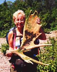
Mary Powell of Flint
holds one of three
moose shovel sheds
she found deep
in the heart
of Ontario's
Lake Superior Provincial Park.
To view the other
moose sheds
found on this trip,
visit the Sheds 'n Skulls
page on this Web site.
(Photo by Mary Powell)
View Gail Staisil's
Photo
Album from this trip
I was having a heck of a time with 47 pounds
on my back, much less conceptualizing a 15 to 25 pound weight
laterally placed on both sides of my head, trying to slip
through the trees unseen. A picture of each antler was carefully
recorded for the Web site's "Sheds
'n Skulls" page, you will want to take note and refer
to that site after reading this trip journal.
Mary's journal entry
A relatively easy day for bushwhacking--there
has been a more or less open trail most of the way. Mapped
some great campsites for future trips. Gargantua Creek is
very pretty--gravelly/rocky with many ferns, blue flags and
lillies.
Finding three moose sheds is unbelievable!
...as is the idea that moose grow and then discard those huge
things in one season. Saw some other interesting things too:
gelatinous tubes (possibly egg cases?) anchored to some rocks
in the creek, mushrooms that looked like small carved wooden
bowls and loons in the lake, of course...
Startled a woodcock along the trail. Camped
for the night near a long-abandoned beaver pond, now a grassy
meadow. The night was utterly still, the stars very bright
and the dew very heavy, almost like rain.
Sue's journal entry
The second day out, after running off Moose
Highway 17 because we were aiming for the Lake, we came out
north of Ryan's Cove. We hit a beautiful rock beach for our
first view of Lake Superior. We were a ways north of the dead
end of the trail at Chalfont Cove, where normal people often
turn around and head back south.
But, we are not normal people. We would
walk along, then come upon a crevasse filled with Lake Superior,
and have to head inland up cliffs and rocks and through brush
to get around the obstacle. Finally, we came upon a wider
crevasse, looked up at the cliffs and hills, considered our
knees, and decided to swim for it.
Michael struck out across first, after
carefully wrapping up his pack and flinging it into the Lake.
Mary went next, without a problem. I flailed along at last,
finally making it over. We had rolled up our foam sleeping
pads to create PFDs, which were a handy thing to have. The
cold lake actually felt good, and other than a few holes in
the pack covers or plastic bags covering our packs, they floated
nicely, and things arrived on the other side mostly dry.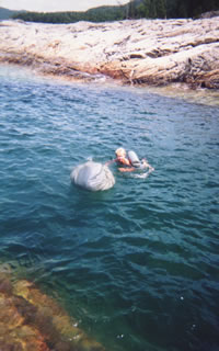
Mary Powell of Flint
swims across
a deep cove
in Lake Superior
with her pack
and a PFD
improvised from her
closed-cell foam
sleeping pad.
(Photo by Mary Powell)
View Gail Staisil's
Photo
Album from this trip
Off we hiked along the rocky shores again,
until we hit an even wider crevasse. Out came the leaky pack
covers, off came the boots, and one by one we crossed again,
swimming a little farther this time. However, the holes in
the pack covers from the first crossing seemed to have magnified
exponentially by the time we swam this second crossing. The
outer supplies in our packs were pretty well soaked, including
my boots and socks that I had rested on the bottom of the
pack.
As water, cohos and seaweed poured out
of my boots, it was time to take stock of this swimming idea.
On the other hand, our alternative was scaling cliffs, and
at the end of the second day Mary and I were both pleading
for the 800 mg ibuprofen for our aching knees!
Mary's journal entry
[Editor's note: Regarding the ibuprofen,
Mary says, "'Pleading' might be a slight exaggeration.
It was more like 'gratefully accepted the ibuprofen generously
offered by our leader' who was probably hoping it would increase
the chances that we would accompany him a while longer..."]
Bushwhacking has its questionable moments
but, besides stumbling on moose sheds, "normal people"
will miss the other things that make it worthwhile--things
like finding a spectacular cliff face far back in the woods,
the you-never-know-what's-around-the-next-corner fun of exploring
where there is no trail, the feeling of success when you calculate
an azimuth, pace it off, and end up where you wanted to be.
Our campsite near Ryan Point gave us a
view of the sunset over Squaw Island after a brief rain dampened
our dinner. On the shore were dramatic veins of red and black
rock. A variety of lichens decorated them with a collage of
bright orange, velvety black and lime green. After a swim
(just for the fun of it) we spent a pleasant evening reading
and talking.
Sue's journal entry
The third morning started off with four
river otter slicing along in the Lake as we ate breakfast.
They were fantastic! Nose up, nose down, tail following. Blueberries
were out, red and white baneberry were out, blue-bead lilies
were in the undergrowth.
At lunch we had not made much headway in
woods bushwhacking, and we had to make it to Chalfont Cove
to meet up with Gail at the northern terminus of the Coastal
(let's go Postal) Trail. Which is why, when faced with our
next set of cliffs along the Lake, Michael came up with the
brilliant idea to construct a raft out of beaver poles to
keep the packs dry as we walked/swam along side.
With his instruction on what size poles
to start gathering from our lunch/beach area, Mary and I began
stacking similar sized poles in various staging areas near
the water's edge. Gathering all the rope we had, Michael spent
the next half hour or so lashing the poles together. 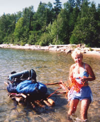
Mary Powell emerges from
the waters of Lake Superior
towing a homemade
wooden raft supporting
the group's gear.
(Photo by Mary Powell)
View Gail Staisil's
Photo
Album from this trip
My contribution to the raft was an old
tennis ball I had found washed up on the beach. I tore at
the outer covering to create bangs, then drew a face on it
and--voila!--Wilson! (apologies to the "Castaway"
movie with Tom Hanks several years back). Popped Wilson onto
the raft, hoisted up the packs, things were a little wobbly.
So Michael added an outrigger to stabilize the load, and off
we went.
We started wading for about 20 yards, but
the water got deeper. Soon, we were all swimming along with
the raft! I had my foam bed roll/PFD tucked under my chin
and was dog paddling away, one arm on the raft. Tried singing
for awhile to pass the time. Cue up Joe Walsh's "Theme
from Boat Weirdoes." After about a half-hour, we decided
a break was in order, and stopped on a rock.
The wind had picked up, and I was immediately
chilled and was ordered to the bank to lay in the sun out
of the wind after a chocolate bar failed to quell my quaking/shivering
jaw. After somewhat warming up, we had to press on to meet
Gail, the clock was ticking and there was another cove to
swim past.
I stayed on the rocks while Mary and Michael
alternately took turns bravely either hauling the raft with
a long rope from shore or swimming with it to get it past
boulders and other obstacles.
The grand entrance...
We rounded the final bend and Michael could
see Gail on the far shore waiting for us to pop off the trail.
Instead, what she saw was a rag-tag group with some goof-ball
bellowing into a piece of black plastic tubing, what sounded
like the mating call of some sick ungulate. This was Michael
announcing our arrival.
We were quite a sight, I am sure. After
a round of photographs to commemorate the event, we disassembled
the raft. Wilson had hung on and spent the night pegged into
a tree near my tarp. I forgot about him in the morning when
we left camp--WILSON!!!! But it was best he stayed in Chalfont
Cove to smile at some other hapless camper, rather than me
carry his sorry orb on the trail ahead.
Mary's journal entry
It's been quite a while since I had that
much fun! The last time I built a raft was almost half a century
ago... and this one worked much better... Gail, as usual,
seemed unruffled by our craziness. It was good to hear what
she's been up to since our last trip together. These park-provided
campsites are flatter, but they sure lack the padding of duff
that you find in the bush!
Mary's journal entry
From Chalfont Cove the trail goes a short
way through a wetland then climbs over rock formations to
an overlook of Indian Harbour--a narrow, sheltered inlet.
A small yacht was anchored there in the midst of idyllic scenery.
After taking in the view awhile we followed the trail inland
again across Cape Gargantua to Warp Bay. WOW!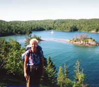
Mary Powell enjoys
the picturesque
view of
Indian Harbour.
(Photo by Mary Powell)
View Gail Staisil's
Photo
Album from this trip
Sheltered sandy beach, forested campsites,
kayakers for company, a river to fish in and, after only walking
about 4 kilometers, Michael says we have the rest of the day
to relax... No problem!
After lunch I explored the shores of a
number of small islands nearby, finding some interesting boating
relics. After a nap, Sue took me (and a leach she had found)
for a fishing lesson: first you walk a couple of kilometers
to find the best available fishing hole... then get the unwilling
bait on the hook....then toss it into the tangle of logs where
a trout may be hanging out.... and hope it doesn't get stuck
there... Our efforts did not secure dinner, but I think I
have the basic idea.
After dinner Sue, Gail and I hiked a 2
kilometer side trail to see Devil's Chair--a rocky offshore
island with an intriguing hole through it. It is visible from
a small cove with a unique black sand beach and two brand
new campsites, one of which was occupied by a young man who
related for us an Indian legend regarding Devils Chair:
It seems that Devil's Chair is where
Manabohzo, who is in some stories the creator of the world,
landed and rested when he jumped over lake Superior after
slaying the monster who now lays beneath the hills called
Sleeping Giant on the north shore of the lake. Indians and
kayakers sometimes still leave tobacco or gifts there seeking
Manabohzo's blessing...
Mary's journal entry
Easy morning's hike with a brief diversion
to see a waterfall on the Gargantua. Found the "Bridge
to Nowhere" nearby. On arriving at Gargantua Bay, found
all the sites were occupied and had lunch at a bush site we'd
selected for the night. Hiking back to get our food cache,
however, we managed to capture one that had just been vacated.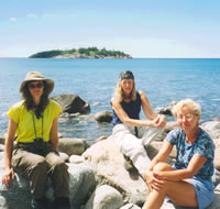
Sue Schenk-Drobny,
Gail Staisil,
and Mary Powell
enjoy a break along
the shore of
Lake Superior.
Gargantua Island is
just offshore.
(Photo by Gail Staisil)
View Gail Staisil's
Photo
Album from this trip
I held down the fort (rough job) while
the others retrieved our gear. Then we retrieved our food
cache. Dusty and tired from the back and forth trips, we went
swimming and settled into our site to relax. Sue and Gail
were still on the beach when a lone kayaker passed by in search
of a place to spend the night...
Sue's journal entry
One night we stayed at a campsite in Gargantua
Bay. Half of the campsites there are located on a beautiful
sand beach, and half on rocky stuff. Really rocky. Turn your
ankle rocky. Anyway, we were lucky enough to get ANY campsite,
it was a very busy summer camping day at Gargantua Bay, and
we were able to snag a rocky site.
I like to clean up at the end of a working
walk day, in an attempt to "wash off the ticks,"
so usually scout out a freezing beaver pond or some other
place to plunk into for a moment of whooping, exhilarating
relaxation. Since the one option I could see here was to somehow
force myself through crashing waves to be able to swim, and
potentially get very bunged up on large rocks and big boulders,
I decided to sit on a large, underwater rock about knee deep,
and let some of the "gargantua" waves crash over
me, sort of a "wave Jacuzzi."
So I did, getting walloped at regular intervals
with screamingly cold water. Felt good! As I was yelling and
whooping away, a kayaker comes paddling by and yells "do
you know of any open camp sites along here?" I replied:
"no, but you can fake it down on the end of the beach,
before the cliffs start." So off he went.
Gail, who was also down on the beach at
the time, and I watched as he approached the cliffs, and he
didn't seem to be able to locate a site. He was bobbing around
hopelessly, Gail and I both watching with concern, and I turned
to her and said, "hey, what the heck, he's a kayaker,
not an ax-murderer, do you care if he stays at our camp site
tonight? Might be good for a few new stories."
She indicated she didn't mind, so we stood
up and waved our arms around for him to come back. Back he
came, and as he approached again, trying to jockey his boat
amongst the rocks, I called out "do you have any RUM?"
He grinned, and indicated no, he did not. So I tried "do
you have any CHOCOLATE, then?" He skillfully made his
way through the boulders to get near to shore to keep from
getting his boat smashed up, looked at me and said "are
you from Marquette?"
Dumbfounded, incredulous, I said "yes.....".
Then he said "well, I'm the POLKA KING!"
Again, dumbfounded, my mind raced, flipping
through the back files and trying to remember if I had been
that BIG of a bender lately that I wouldn't remember polkaing
with the Polka King.....then, I remembered! "KARL!"
I yelled! "Karl, is it really you????"
It all came back. I had met Karl in February
this past year, the friend of a mutual friend. Several of
us had cross country skied at the Porcupine Mountains one
weekend. At the end of the day, the mutual friend, who happened
to be a dance instructor in Houghton, showed us a few steps
of the merengue and western swing back at the cabin we were
staying in, to the music from a CD player.
A polka came on, Karl was sitting back
hiding in a corner, and I forced him off the couch and into
the polka stance where we practiced until I figured he was
good enough to send off to any wedding reception he might
get invited to in South Range that spring. A fun afternoon
was had by all, and all too soon both Karl and the dance instructor
headed back to Houghton for some evening concert, leaving
us pondering over the merengue.
At any rate, here was Karl in from the
Lake! "What was your name again?" he asked (I had
not apparently made THAT big of an impression on him!). I
found out later while talking to him he wasn't in a kayak
at all, but a "decked canoe," something new to me.
Karl is quite the accomplished canoeist,
and later that evening we watched the stars come out as he
recounted stories about the characters he has met while traveling
in his canoe on Lake Superior for several weeks every summer.
We had lots of laughs. The next morning at breakfast, he and
Michael traded stories about traveling in Canadian waters,
and shared equipment tips. We all enjoyed the visit from the
Polka King.
Mary's journal entry
It was hard to part with Gail's company,
but she had obligations and we were unable to entice her to
continue.
The hike to Rhyolite Cove was rocky and
rough, but short and included some awesome views. The rocks
in this cove are pink, as is the gravelly sand of its beach.
On a short explore around the next point
I found another cove with the same stone in strangely sculpted
shapes--rounded mounds that looked like melted birthday cakes.
On their sides were vertical fracture lines and chunks were
easy to break off in five or six sided columns several inches
in diameter. The combination of weathered rocks and geometric
shapes reminded me of photos of Anasazi cliff dwellings.
The trail guide said these rocks were rhyolite...sounds
like the trade name for some kind of building material...
First source I looked it up in told me cryptically that it
was "an extrusive metamorphic." Not too enlightening.
Further investigation disclosed that this columnar rhyolite
is formed when molten granite flows out on the surface and
cools rapidly. The resulting rock is dull and brittle, breaking
readily into angular chunks and slices and easily eroded by
wind and water.
The water in Rhyolite Cove seemed colder,
but we swam anyway. Shortly after our arrival there a group
of teenage boys, led by a pair of somewhat worn looking counselors,
occupied the other campsite. Noisy and full of energy, they
seemed to have us surrounded in no time. Michael took to calling
them "The Cavalry." Sue seemed more quiet than usual.
After dinner we practiced firebuilding. Though the wood valiantly
resisted ignition, in the end we had tea...
Mary's journal entry
The trail guide describes the stretch from
Rhyolite to Beatty Cove as "a very rugged 8 kilometers."
I would concur. It took a big piece of this day to cover 4
kilometers of it to Buckshot Creek. The cove there was even
prettier than Rhyolite in my opinion; rocky points shielded
white gravel beaches and huge crevasses hid clear water to
swim in. 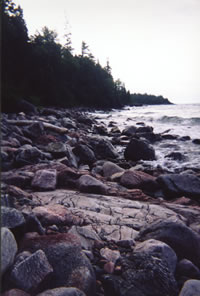
Waves break
along the
rock-strewn
shoreline of
Lake Superior.
(Photo by Mary Powell)
View Gail Staisil's
Photo
Album from this trip
Buckshot Creek joins the lake here, adding
the sound of water flowing over rapids and the possibility
of fishing. "The Cavalry" arrived in a little while
though, making fishing less attractive. We retreated to "our"
side of the lagoon, read, relaxed and watched the resident
loons and mergansers.
Sue remained somewhat subdued--concerned
about how her dogs were doing with their sitter and whether
her husband had survived the course on bush plane piloting
he was taking in her absence. We decided that evening to quit
lazing around and cut a couple days off the trip as feeling
anxious is not compatible with having fun.
Mary's journal entry
Michael set a brisk pace--kept disappearing
into the distance actually... We covered kilometers of those
twisting forest trails and scrambled from cairn to cairn along
the rocky coastline, stopping only briefly at a couple of
overviews. We breezed by Beatty Cove and on to the Baldhead
River. River fording was a routine operation by now.
After swimming across, pack in tow, hiked
the kilometer or so of expansive curved gravel beach to a
secluded campsite behind a screen of trees at the far end.
Below this campsite, we found some awesome swimming opportunities.
Eroded rock formations allowed us to recline in comfort and
let the waves wash over us. We swam in huge crevasses where
we could see jumbles of boulders 30 feet below through the
clear water.
Also napped, read, cooked dinner, watched
the sunset--acutely aware this was our last night in the bush.
Mary's journal entry
In the morning, a few kilometers of relatively
easy hiking in and out of woods and along smaller-scale rock
formations brought us to a broad sand beach at the mouth of
the Coldwater River.
We swam and changed into traveling clothes,
arranging the trip in our memories. We retrieved the second
car, loaded our gear and headed for a farewell meal at the
same restaurant where we'd started. Another fine stint in
the bush....
Read
another journal...
Return
to top of page | Return
to home page
In
God's wilderness lies the hope of the world,
the
great, fresh, unblighted, unredeemed wilderness.
—
John Muir 1838-1914, Alaska Wilderness, 1890
Content
Copyright © by Michael A. Neiger
All rights
reserved.
Comments?
Suggestions? Dead links? Inaccurate info?
Contact the
WebMaster at mneiger@hotmail.com
A
MacroMedia DreamWeaver 4 and Fireworks 4 production
|