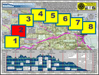
| Start point: |
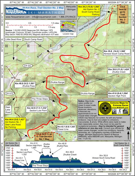
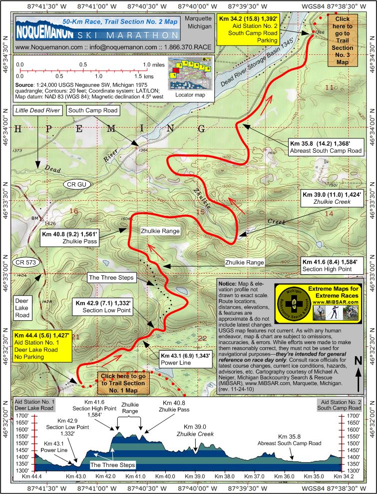
Km 44.4 (5.6)—Aid Station
No. 1, Deer Lake Road, 1,427 feet |
| End point: |
Km 34.2 (15.8)—Aid Station
No. 2, South Camp Road, 1,392 feet |
| Length: |
10.2 km |
|
Elevation Data
|
| Ascending: |
+ 449 feet |
| Descending: |
- 487 feet |
| Change: |
- 38 feet |
| Minimum: |
1,332 feet |
| Maximum: |
1,584 feet |
|
Description
Aid Station No. 1
(Deer Lake Road) at Km 44.4 (5.6, 1,427 feet) is situated
about 300 meters east of Deer Lake Road. No parking
is available.
From the aid station,
racers will ski down a slight draw along a ridgeline
to their left until they cross under a power line
at Km 43.1 (6.9, 1,343 feet).
At Km 42.9 (7.1, 1,332 feet), racers
will have reached the section's lowest elevation point.
Almost immediately, they'll begin a series of difficult
ascents—about 250 feet in all and known collectively
as Three Steps—as they work their way up into
the Zhulkie Range.
At Km 41.6 (8.4, 1,584 feet) racers
will have reached the top of the Zhulkie Range, and
the section's highest elevation point.
After clearing Zhulkie Pass at Km 40.8
(9.2, 1,561 feet), a long downhill traverse will bring
racers to the Zhulkie Creek crossing at Km 39.0 (11.0,
1,424 feet).
Once across the creek, racers will continue
working their way through the Range's foothills until
they break out onto the plains of the Little Dead
River Valley, adjacent to the South Camp Road at Km
35.8 (14.2, 1,368 feet).
 Another
1,500 meters of relatively flat skiing will bring
racers to Aid Station No. 2 (South Camp Road) at Km
34.2 (15.8, 1,392 feet), which is located adjacent
to the east side of South Camp Road. Crewed
by members of the Ishpeming
Pioneer Kiwanis Club, it has roadside parking. Another
1,500 meters of relatively flat skiing will bring
racers to Aid Station No. 2 (South Camp Road) at Km
34.2 (15.8, 1,392 feet), which is located adjacent
to the east side of South Camp Road. Crewed
by members of the Ishpeming
Pioneer Kiwanis Club, it has roadside parking.
Click
here to read about Trail Section No. 3.
|
|
|
|
Click
here or on map above
for high-resolution,
1:24,000-based, USGS imagery of Trail Section No.
2
|
Notice:
The maps and elevation profile charts
are not drawn to exact scale. Route locations,
distances, elevations, features, statistics,
and descriptions are approximate, and do not
include the latest changes or reroutes. USGS
base map features are not current. As with any
human endeavor, this map and chart are subject
to omissions, inaccuracies, and errors. While
efforts were made to make them reasonably correct,
they must not be used for navigational purposes—they
are intended for general reference on race day
only. Consult race officials for the
latest course changes and reroutes as well as
current ice conditions, hazards, advisories,
etc.
Web page design, hosting,
& cartography courtesy of Michael A. Neiger
of Michigan Backcountry Search and Rescue (MiBSAR),
www.MiBSAR.com,
in Marquette, Michigan.

Michael welcomes your
comments and suggestions on how to improve the
maps, charts, and information on this Web page
at mneiger@hotmail.com.
|
|
