| Start point: |
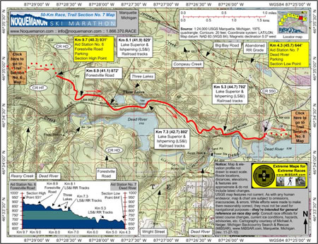
Km 9.7 (40.3)—Aid
Station No. 6, Forestville Road, 931' |
| End point: |
Km 4.3 (45.7)—Aid Station
No. 7, 644' |
| Length: |
5.4 km |
|
Elevation Data
|
| Ascending: |
+0 feet |
| Descending: |
-291 feet |
| Change: |
-291 feet |
| Minimum: |
644 feet |
| Maximum: |
931 feet |
|
Description
 Aid
Station No. 6 (Forestville Road) at Km 9.7 (40.3,
931 feet) is located adjacent to the Noquemanon
Trail Networks' Forestville Trailhead Facility,
which is situated about a kilometer northwest of the
point where the Forestville Road crosses the Lake
Superior and Ishpeming (LS&I) Railroad tracks.
Parking is available. Aid
Station No. 6 (Forestville Road) at Km 9.7 (40.3,
931 feet) is located adjacent to the Noquemanon
Trail Networks' Forestville Trailhead Facility,
which is situated about a kilometer northwest of the
point where the Forestville Road crosses the Lake
Superior and Ishpeming (LS&I) Railroad tracks.
Parking is available.
From the aid station, the section's
highest elevation point, racers will ski a short distance
before crossing Forestville Road at Km 8.9 (41.1,
872 feet).
As racers reach the Three Lake area,
they'll cross the tracks of the Lake Superior and
Ishpeming (LS&I) Railroad twice, once just west
of the lakes at Km 8.1 (41.9, 829 feet) and once just
east of the lakes at Km 7.3 (42.7, 802 feet).
Once clear of the Three Lakes area,
racers will ski along the north side of the LS&I
tracks for 2.0 km before crossing them one final time
at Km 5.3 (44.7, 702 feet).
Another short ski will bring racers
to Aid Station No. 7 (Dead River), the section's lowest
elevation point, at Km 4.3 (45.7, 644 feet), which
is located about 300 meters southwest of County Road
550, the Big Bay Road. Parking is available.
Click
here to read about Trail Section No. 8.
|
|
|
|
Click
here or on map above for high-resolution,
1:24,000-based, USGS imagery of Trail Section No.
7.
|
Notice:
The maps and elevation profile charts
are not drawn to exact scale. Route locations,
distances, elevations, features, statistics,
and descriptions are approximate, and do not
include the latest changes or reroutes. USGS
base map features are not current. As with any
human endeavor, this map and chart are subject
to omissions, inaccuracies, and errors. While
efforts were made to make them reasonably correct,
they must not be used for navigational purposes—they
are intended for general reference on race day
only. Consult race officials for the
latest course changes and reroutes as well as
current ice conditions, hazards, advisories,
etc.
Web page design, hosting,
& cartography courtesy of Michael A. Neiger
of Michigan Backcountry Search and Rescue (MiBSAR),
www.MiBSAR.com,
in Marquette, Michigan.
Michael welcomes your
comments and suggestions on how to improve the
maps, charts, and information on this Web page
at mneiger@hotmail.com.
|
|