| Start point: |
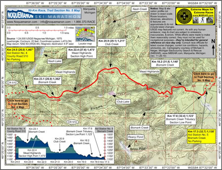
Km 24.0 (26.0)—Aid
Station No. 4, County Road 510, 1,467' |
| End point: |
Km 17.3 (32.7)—Aid Station
No. 5, Bismark Creek, 1,138' |
| Length: |
6.7 km |
|
Elevation Data
|
| Ascending: |
+290 feet |
| Descending: |
-624 feet |
| Change: |
-334 feet |
| Minimum: |
1,123 feet |
| Maximum: |
1,473 feet |
|
Description
Aid Station No. 4 (County Road 510)
at Km 24.0 (26.0, 1,467 feet) straddles Country Road
510. No parking is available.
From the aid station, racers descend
to Bismark Creek at Km 23.1 (26.9, 1,362 feet) before
climbing into the Mead Highlands, reaching the section's
high elevation point at Km 22.4 (27.6, 1,473 feet).
Racers will get their first glimpse
of Lake Superior as they descend 250 feet from the
high point to cross Club Creek at Km 20.9 (29.1, 1,211
feet).
Bismark Creek is crossed again at Km
18.2 (31.8, 1,140 feet), and one of its tributaries
is crossed at Km 17.6 (32.4, 1,123 feet), before racers
reach Aid Station No. 5 (Bismark Creek) at Km 17.3
(32.7, 1,138 feet), which is located on a plateau
at the western limit of the Forestville Plains. No
parking is available.
Click
here to read about Trail Section No. 6.
|
|
|
|
Click
here or on map above for high-resolution,
1:24,000-based, USGS imagery of Trail Section No.
5
|
Notice:
The maps and elevation profile charts
are not drawn to exact scale. Route locations,
distances, elevations, features, statistics,
and descriptions are approximate, and do not
include the latest changes or reroutes. USGS
base map features are not current. As with any
human endeavor, this map and chart are subject
to omissions, inaccuracies, and errors. While
efforts were made to make them reasonably correct,
they must not be used for navigational purposes—they
are intended for general reference on race day
only. Consult race officials for the
latest course changes and reroutes as well as
current ice conditions, hazards, advisories,
etc.
Web page design, hosting,
& cartography courtesy of Michael A. Neiger
of Michigan Backcountry Search and Rescue (MiBSAR),
www.MiBSAR.com,
in Marquette, Michigan.

Michael welcomes your
comments and suggestions on how to improve the
maps, charts, and information on this Web page
at mneiger@hotmail.com.
|
|