|
Description
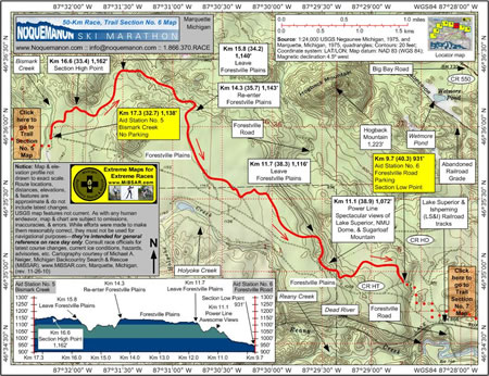
Aid Station No. 5 (Bismark Creek) at
Km 17.3 (32.7, 1,138 feet) is located on a plateau
at the extreme, western limit of the Forestville Plains.
No parking is available.
From this aid station, racers will work
there way a bit north and east along the Forestville
Plains as the racecourse avoids a couple of 180-foot-high,
spire-like hills blocking their path eastward.
Along the way, they'll come to the section's
highest elevation point at Km 16.6 (33.4, 1,162 feet).
At the 15.8 Km (34.2, 1,140 feet) point,
racers will descend off the north side of the plains
some as the racecourse slips around the northern-most
rise.
 As
racers reemerge back onto the Forestville Plains proper
at Km 14.3 (35.7, 1,143 feet), they'll begin to see
additional groomed ski trails and junction signage,
all of which are part of an extensive network of trails
managed by the Noquemanon
Trail Network. As
racers reemerge back onto the Forestville Plains proper
at Km 14.3 (35.7, 1,143 feet), they'll begin to see
additional groomed ski trails and junction signage,
all of which are part of an extensive network of trails
managed by the Noquemanon
Trail Network.
After 2.6 kilometers of relative flat
skiing on the plains, racers will arrive at Km 11.7
(38.3, 1,116 feet) where they'll begin descending
to the next aid station.
 As
racers cross under a power line at Km 11.1 (38.9,
1,072 feet), they'll be treated to spectacular views
of Lake Superior as well as Sugarloaf Mountain to
the northeast and the Northern Michigan University's
Superior Dome—the finish line—to the southeast. As
racers cross under a power line at Km 11.1 (38.9,
1,072 feet), they'll be treated to spectacular views
of Lake Superior as well as Sugarloaf Mountain to
the northeast and the Northern Michigan University's
Superior Dome—the finish line—to the southeast.
Just beyond the power line, racers will
leave Negaunee Township and enter Marquette Township.
Aid Station No. 6 (Forestville Road)
at Km 9.7 (40.3, 931 feet), the section's lowest elevation
point, is located adjacent to the Noquemanon Trail
Networks' Forestville Trailhead Facility, which is
situated about a kilometer northwest of the point
where the Forestville Road crosses the Lake Superior
and Ishpeming (LS&I) Railroad tracks. Parking
is available.
Click
here to read about Trail Section No. 7.
|