| Start point: |
Km 29.3 (20.7)—Aid Station
No. 3, Granite Point Escarpment, 1,546 feet |
| End point: |
Km 24.0 (26.0)—Aid Station
No. 4, County Road 510, 1,467' |
| Length: |
5.3 km |
|
Elevation Data
|
| Ascending: |
+199 feet |
| Descending: |
-269 feet |
| Change: |
-70 feet |
| Minimum: |
1,455 feet |
| Maximum: |
1,603 feet |
|
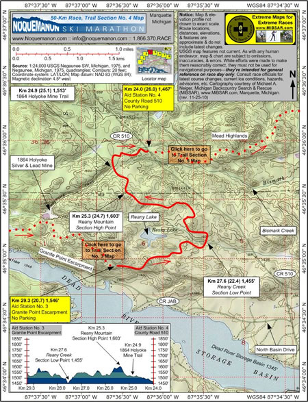
Description
 Aid
Station No. 3 (Granite Point Escarpment) at Km 29.3
(20.7, 1,546 feet) is located atop the escarpment,
some 200 meters north of North Camp Road. Crewed by
members of the Negaunee Lions Club, it has no available
parking. Aid
Station No. 3 (Granite Point Escarpment) at Km 29.3
(20.7, 1,546 feet) is located atop the escarpment,
some 200 meters north of North Camp Road. Crewed by
members of the Negaunee Lions Club, it has no available
parking.
From the aid station, racers head east
for a nonstop roller coaster of ups and downs, and
twists and turns. When racers cross Reany Creek at
Km 27.6 (22.4, 1,455 feet), they will be at the section's
lowest elevation point.
Heading west, racers will ascend Reany
Mountain at Km 25.3 (24.7, 1,603 feet), which represents
the section's highest elevation point.
After descending into the Holyoke Valley
and crossing the 1864 Holyoke Mine Trail, racers will
ski east to Aid Station No. 4 (County Road 510), at
Km 24.0 (26.0, 1,467 feet), which straddles Country
Road 510. No parking is available.
Click
here to read about Trail Section No. 5.
|
|
|
|
Click
here or on map above for high-resolution,
1:24,000-based, USGS imagery of Trail Section No.
4
|
Notice:
The maps and elevation profile charts
are not drawn to exact scale. Route locations,
distances, elevations, features, statistics,
and descriptions are approximate, and do not
include the latest changes or reroutes. USGS
base map features are not current. As with any
human endeavor, this map and chart are subject
to omissions, inaccuracies, and errors. While
efforts were made to make them reasonably correct,
they must not be used for navigational purposes—they
are intended for general reference on race day
only. Consult race officials for the
latest course changes and reroutes as well as
current ice conditions, hazards, advisories,
etc.
Web page design, hosting,
& cartography courtesy of Michael A. Neiger
of Michigan Backcountry Search and Rescue (MiBSAR),
www.MiBSAR.com,
in Marquette, Michigan.

Michael welcomes your
comments and suggestions on how to improve the
maps, charts, and information on this Web page
at mneiger@hotmail.com.
|
|