The Ojibwas named it, "Kitchi Minis,"
meaning Great Island. Later, the French called it, "Les
Grande Isles." And as we stood on the bay shores at Munising,
looking north just a few miles off, we had to agree--it was
a Grand Island.
Many Indian legends tell of the Island's
conception by the Great Spirit who amused himself by dreaming
up and creating monstrous giants. Fearing his latest creation
would be larger 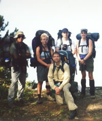 and
more powerful than the artist himself, he threw down the beast
before breathing life into it, leaving 3 discarded islands
below in Lake Superior. and
more powerful than the artist himself, he threw down the beast
before breathing life into it, leaving 3 discarded islands
below in Lake Superior.
John, Mary, Rick, Dave, and Lori
pause on a high sandy bluff on
the south end of the Island's Thumb.
(Photo by Rick Szumski)
Two small islands, Williams and Wood are
said to be the hands of the beast while Grand Island is its
body, measuring 8 miles long, north to south, and 3 miles
wide.
There have been many inhabitants and visitors
on the Island, some whose artifacts date them as far back
as 2,000 BC. Members of the Ojibwa Nation, as well as European
and American explorers, made frequent trips to the Island
to hunt, trap, fish, and trade.
Two of the more recent owners of land on
the Island were the Williams family from Vermont, who built
there in 1840, and the Cleveland Cliffs Iron Company, which
began purchasing property on the Island in 1900 and owned
it until 1990.
Currently, some parcels are privately owned,
while a majority of the Island belongs to the federal government
and is managed by the Forest Service as a National Recreation
Area.
This was both my first trip to Grand Island
as well as with the Sierra Club. I was a bit nervous, not
knowing what to expect. But after meeting my riding partner,
Mary in Flint, and learning about her experiences on previous
trips with the club, I knew I'd have a great time.
Our trip and subsequent exploration of
the Island began on a beautiful, clear day after meeting for
an early breakfast at the Dog Patch Restaurant in Munising,
Friday morning. After an introduction to fellow hikers Rick,
John, and Dave, and direction from our fearless leader, Michael,
we headed to the ferry dock near Powell Point.
Once there, we weighed our packs and then
loaded them on to the waiting ferry. The trip across the West
Channel to Williams Landing could not have spanned more than
a half mile or taken longer than ten minutes. As we approached
Murray Bay, small cabins dotted the eastern shoreline here
and there.
One of the cabins on Murray Bay is currently
used as the Visitor's Center and it was our first stop. Inside,
we read a bit about the history and wildlife of the Island.
We also got an overview of our route and itinerary, and learned
that we would be crossing over the tombolo to get to the Island's
thumb, our destination.
Over ten thousand years ago, before Lake
Superior receded to its current depth, Grand Island was separated
into 3 islands. 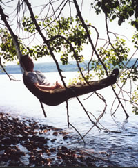 The
tombolo is a very sandy and marshy strip of land now connecting
the main island to its thumb. The
tombolo is a very sandy and marshy strip of land now connecting
the main island to its thumb.
Dave Wiltse--probably
dreaming of the day
he brings his sons,
Graham and Joshua,
to the Island--shows
Sierra Club trekkers
how to rig a bivouac
over Lake Superior
on the Island's Thumb.
(Photo by Rick Szumski)
We started out hiking on a two-track dirt
road, heading north along Murray Bay. Michael pointed out
remnants of the Williams Hotel, part of which was built as
a family home by Abraham Williams, a resourceful pioneer,
skilled blacksmith, builder, and mason.
We snacked on ripe thimbleberries along
the way and stopped to look at the sunny flowers of the St.
John's Wort that John, our wildflower expert, had pointed
out. We could have left our food bags behind and made meals
out of what we foraged on the Island.
Throughout the course of the weekend, we
saw blue berries, wild rhubarb, raspberries, and SNOW PEAS!
Further along, we investigated an early 1900's cottage built
from roughhewn timbers that was being renovated.
Next, we explored a scattering of small
caves carved out by Lake Superior thousands of years ago.
Before we left Murray Bay, a small footpath took us to the
Williams Family cemetery. Not much further on, a short jaunt
from the trail brought us to Duck Lake, a serene haven for
waterfowl.
We were ready for lunch when we reached
Trout Bay Beach, and Mary was ready for a swim! The high temperatures
we had been experiencing the week before our trip, which ranged
between 80 and 90 degrees, continued during our trip.
The traditionally frigid water of Superior
was refreshing to us whenever we happened upon it. We swam
every chance we got, sometimes 3 or 4 times a day. Michael
kept after us to drink one quart of water an hour, and showered
us with capfuls of water on the trail to cool our heads.
After our break at Trout Bay, we bushwhacked
south to Muskrat Point and Agate Island to make camp for the
night near the beach. Arriving in the early afternoon, we
had plenty of time to swim and wade through the water.
We even explored the carcass of an old
boat. In less than two feet of water, the keel and ribs of
the vessel lay open, revealing its simple construction. Several
boats had anchored out in Murray Bay, and we could see their
dive flags as they investigated 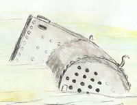 numerous
other wrecks in deeper water. numerous
other wrecks in deeper water.
A boiler from an old shipwreck
sits sheltered in Murray Bay,
a few meters north of Agate Island.
(Drawing by Mary Powell)
Further down the beach, near Agate Island,
the boiler of another sunken boat had washed up on shore.
We also found a perfectly preserved, milled timber at the
waters edge. It had been branded on one end with a large C
and the name LOUD. Mary made a sketch of it for Michael to
research later.
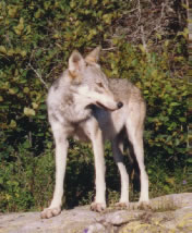
Dave discovered scat, most likely from
an owl, that contained the bones and fur of a white mouse.
On our way out of camp in the morning, we found a pile of
blue-jay feathers that appeared to have been scattered about
the ground during a violent struggle.
Unfortunately, the bird didn't stand a
chance against whatever got to it. We did however get an opportunity
to see the black-and-white-tipped, brilliant-blue feathers
of the blue jay up close.
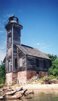
Our first task for the new day was to head
to Wick Point and then on to the East Channel Lighthouse built
in 1867. It was currently being restored. Private land surrounded
the lighthouse, so the only way we could view it legally was
to swim out along the private shoreline until we were near
the lighthouse.
Dave, John and myself decided to stay back
with the packs and enjoy the shade while snacking and napping.
Mary, Rick, and Michael headed out to sea and returned about
an hour later with pictures and tales of hoisting each other
up to peer through the windows.
From the lighthouse, we bushwhacked towards
Trout Point, at the northern tip of the thumb. Occasionally,
we followed grown over logging roads built and used by CCI.
When we reached the water once again, we found ourselves looking
down at it from 100-foot-high sandstone cliffs.
From atop the cliffs, Michael spotted the
portal cave he had found a year or two earlier and was excited
to let us explore it. Mary found a way down to a tiny beach
nearby in no time, and from there we swam around the cliffs
and into the cave.
Large slabs of sandstone, which had fallen
from the cliff above, laid in the water along the way. In
these areas, were able to wade a ways before having to swim
again. We were all thrilled to be able to swim right into
the main mouth of the cave, and then back out by way of one
of two smaller portals.
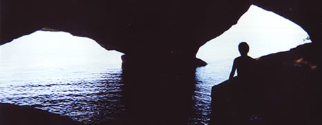
After successfully scouting a route down
the steep, sandstone cliffs of the Thumb, and leading hikers
on a swim in Lake Superior to gain access to a huge, remote,
multi-entrance sea cave, Mary Powell takes a well deserved
break. (Photo courtesy of Lori Watson)
While swimming, one of my toe rings slipped
off and remains on the bottom of Lake Superior to this day.
Michael teased me and announced the cave would now be named
Toe Ring.
That evening, we camped nearby, very close
to another set of caves. However, these were old, dry caves
situated along the top of the 100-foot sandstone cliffs.
Michael had named one of the caves Lantern
Cave since he had found an old railroad lantern in it a couple
years ago. He set up his bivy in one of the caves well back
from cliff's edge (the next morning, he commented about how
damp the cave was).
Before calling it a night, we enjoyed dinner
on a ledge about half way down the cliff wall. By attaching
a rope to Michael's little cooking pot, we were able to dip
and hoist up all the water we needed. From time to time, passing
boaters thought we were somehow stranded and stopped to offer
help. Others simply inquired as to how we managed to get where
we were.
Sunday morning, we pulled out of camp early
and bushwhacked our way to the two-track that took us back
to Trout Bay. We reached the beach around 10:30 a.m. and jumped
into the water as the heat had already reached 80 degrees,
according to John's thermometer.
Mary, Rick, and I swam out and around the
cliffs to Platter Rock, a large sandstone slab protruding
from the water just off shore. When we pulled ourselves up
onto it, we discovered a round indentation on the surface
that someone had used as a fire pit. Unfortunately, others
had desecrated the rock by 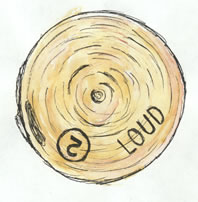 carving
their names into the soft surface. carving
their names into the soft surface.
A partially submerged log
from a logging operation conducted
on the Island long ago was spotted near
Agate Island in Murray Bay.
The perfectly preserved number
and name imprints helped identify
which logging company owned the log
as it was rafted up with 100's of others
and towed to a nearby sawmill.
(Drawing by Mary Powell)
After our swim, we doubled back to Williams
Landing on the same trail we hiked along on our first day.
Once back at the landing, we swam in the cool water again
while waiting for the ferry to pick us up and take us back
to our vehicles in Munising.
All my worries about the trip were
for naught. This was the best hiking trip I'd ever been on.
Backpacking with people who were knowledgeable about so much
of the Island's history, wildlife, and flowers added so much
more than I could have experienced on my own. I'll be back
for more trips with the Sierra Club!
Read
another journal...
|