|
Thirty inches of snow fell on some parts
of the UP in the week before our trip. The forecast for the
weekend was constantly changing. Michael, our trip leader,
told us to bring lots of layers and snowshoes just in case.
John H. wondered aloud if, having had a year of very reasonable
weather for our trips, this would be our time to be tested.
Apparently, however, our number wasn't
up: the weekend turned out partly sunny with daytime temperatures
in the 60's and nighttime temperatures dipping into the 30's.
Awesome weather for so late in the fall!
It was an experienced group of hikers that
assembled Saturday morning at the Pigeon River State Forest
Campground--eight fugitives from civilization seeking a weekend
of 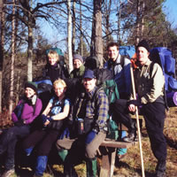 enjoyable
outdoor exercise and relaxation. enjoyable
outdoor exercise and relaxation.
Loretta, Gail, Mary,
John, Dave, Jeff, and
Craig (left to right) pause at an
overlook along the
High Country Pathway.
(Photo by Gail Staisil)
After a somewhat lengthy shuttle of vehicles
(and a bit of joking about whether we were actually going
to hike that day or put it off 'til the next) we began with
an easy on-trail segment going south and then east along the
High Country Pathway (HCP).
Clouds came and went as we walked. The
sun warmed us a bit, though being near winter solstice, it
stayed low in the southern sky. Around 4 PM it became apparent
that there wasn't much daylight left. We decided to bushwhack
over to Hardwood Creek and find a sheltered spot with accessible
water.
This turned out to be a decision to camp
in a cedar swamp. As darkness fell we spread out along the
creek looking for non-soggy, reasonably flat areas big enough
to sleep on. Accessible water was definitely not a problem.
After the evening meal, some chose to sleep, while others
read or chatted before turning in.
We rose with the sun--which is to say,
not very early at all. There were a few clouds at first but
the sky cleared rapidly. We bushwhacked a little more than
a klick (a kilometer) through mixed pine and hardwood forest
to pick up the HCP again 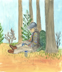 as
it ascended a long, steep hill to the site of an old fire
tower. as
it ascended a long, steep hill to the site of an old fire
tower.
A hiker takes a
water break
high on hill
where a
fire tower
was once located.
(Watercolor by Mary Powell)
Some of us joked about the signage we encountered.
In several places there were cleared areas with benches overlooking
awesome vistas. At each one, there was a "scenic overlook"
sign--as if the overlook might somehow be missed without it.
We passed several more spots where the
distant hills and intervening valleys came into view. Dave
pointed out that we were probably mistaken in thinking that
these views were scenic since they were not signed as such.
At the site of the old fire tower, we took a break and enjoyed
the sunshine and the nice view.
Another hour of hiking brought us to the
sound of water dropping over an obstruction--in this case,
probably a beaver dam as the river had spread beyond its banks
and into the trees. 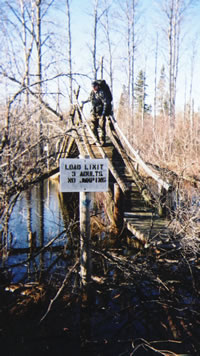 Rounding
a turn in the trail, we found a very worn and rustic bridge
with a cautionary sign: "Load limit three adults--no
jumping." Rounding
a turn in the trail, we found a very worn and rustic bridge
with a cautionary sign: "Load limit three adults--no
jumping."
Dave Wiltse of
Royal Oak
carefully sizes up
a rather unique
wilderness bridge
over the flooded
waters of the
Black River.
(Photo by Mary Powell)
This led to a discussion as to whether
that meant no jumping on the bridge or no jumping off of it.
We also questioned whether it meant three adults with packs
or without? We decided three was too many either way and tackled
it one at a time, balancing on submerged branches to reach
the approach and climbing over a fallen tree midway across
it.
Reaching the far side safely, we hiked
a bit further and found an open area overlooking the river
that made an ideal lunch spot.
Afternoon found us crossing a series of
ridges and their intervening valleys. On the topo map, blues
lines tracing several of these valleys meant we would be able
to replenish our dwindling water supplies. Our plan was to
pick up water, drop Gail off at her car (she had to be back
to work on Monday) and then find a spot to camp in the hills
ahead.
However, we found only jeep trails where
the creeks--apparently seasonal ones--were supposed to be.
We quickly considered a number of alternatives as the sun
sank toward the distant tree line. We settled on "plan
F" (or maybe it was "G"). We would find a place
to bivouac and while the rest of us set up camp, Michael would
walk with Gail to her car to replenish our water supply.
As night closed in, one of the many clearings
created in the woods to allow the elk to forage became our
bivouac spot.
While most of us set up our shelters along
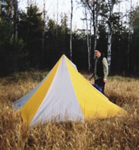
the tree line, Craig found an ideal spot for his "Megamid"
near the center of the flat grassy field. With the absence
of snow, the field's plowed, gravelly edge provided a rare
opportunity to have a safe, no-trace campfire. We were soon
gathering wood for that purpose.
After Michael returned with water, most
of us spent the evening enjoying dinner and conversing around
the fire. We were treated to a full moon rising amidst scudding
clouds. There was enough moonlight to permit a stroll in the
woods before retiring--no headlamp needed.
Breaking camp in the early morning chill
was accompanied by comments like, "Could be worse, I
could be stuck in traffic . . . or worse yet, already at work!"
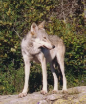
Another hiker quipped, "What with the moon shining, the
coyotes howling, and the birds chirping, it's a wonder anyone
can sleep out here!"
With only a couple of hours between the
cars and us, we decided on a side trip to scope out the potential
of a couple of high ridges for places to camp in the future.
We climbed a high ridge that we dubbed "Eagle Ridge"
for the eagle we saw soaring about, white head and tail flashing
in the sun.
With its thick cushion of pine needles
and panoramic view of the surrounding hills, we all agreed
it would make an excellent place to camp on our next trip.
It was all downhill after Eagle Ridge. Shortly after noon,
another good trip came to an end as we arrived at Michael's
car.
Read
another journal...
|