On a Wednesday
evening in the end of August, having completed a long but
not unpleasant trek from the lower peninsula, I arrived at
the outskirts of Munising with my carpool partner, Lori Watson,
for the second time this summer. It was to be the take off
point for a five day hike at Pictured Rocks as it had been
for a trip to Grand Island a month earlier.
We bypassed the
city tourist park, which we'd found to be less than 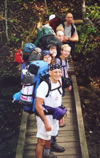 satisfactory
on the last trip, and headed for the USFS Bay Furnace Campground
a little to the west in the village of Christmas. There, we
found many of the amenities the tourist park lacked: relative
freedom from road noise, spacious forested sites, quiet neighbors,
and ground that you can get a stake into. satisfactory
on the last trip, and headed for the USFS Bay Furnace Campground
a little to the west in the village of Christmas. There, we
found many of the amenities the tourist park lacked: relative
freedom from road noise, spacious forested sites, quiet neighbors,
and ground that you can get a stake into.
Bob, Sue, Lori, Mary, Mike,
John, and Michael pause
over a tributary of the
Chapel River.
(Photo by Gail Staisil)
After claiming
our spot and setting up shelter, we ventured back to the highway
seeking dinner. A couple hundred yards from the campground
driveway we found Foggy's Steakhouse and Bar. There you can
cook your own steak on an open grill--or for an additional
$2.00 they will cook it for you. Not being quite hungry enough
for steak, we ordered sandwiches which were very good.
After dinner,
Lori lightened her pack and read while I ambled down the beach
savoring the cool breeze, the view of Grand Island across
the bay, and the waning sunset. I returned to camp by the
light of an almost full moon. The weekend was looking very
promising.
Thursday morning, Lori and I joined other
members of the group at the Dogpatch restaurant, an easy-to-find
place with a varied menu and a decor flavored by the 'Lil
Abner cartoon strip.
Starting the trip with us were Mike Ugoroski
from Flint, Bob Massa from Bloomfield Hills, John Hergott
from Fenton, and our leader, Michael Neiger from Marquette.
Gail Staisil from Midland and Sue Schenk Drobny from Marquette
would be joining us later. Over pancakes and a smorgasbord
we caught each other up on what we'd been doing since our
last trips together.
Breakfast concluded, we drove toward the
park. The sky 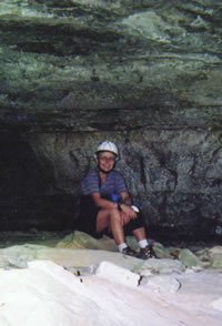 darkened
and there were heavy showers, but by the time we lifted our
packs to begin the hike, the sun was out again. After walking
a short way down a gravel road, we began a bushwhack along
a section line to avoid crossing private land. darkened
and there were heavy showers, but by the time we lifted our
packs to begin the hike, the sun was out again. After walking
a short way down a gravel road, we began a bushwhack along
a section line to avoid crossing private land.
Mary Powell takes a break
from exploring the many
and varied caves secreted
away along the rim of
the Chapel River Basin.
(Photo by Mary Powell)
On the far side of a small creek, the brush
became thicker and in a little while our footprints were filling
with water as we lifted our boots. Still farther along we
found ourselves stepping from hummock to hummock and finally
we were balancing on roots, fallen saplings, and small tufts
of grass.
Somewhere nearby was a stream with very
leaky banks. Michael suggested we might want to change to
sandals or aqua socks as we would be fording the Miners River
soon. Those with good balance and dry boots did that. Some
of us decided there was no use in getting a second pair of
footgear wet.
We came upon the river just below the beaver
dam responsible for the widespread flooding. Fording was a
bit tricky but was accomplished without major problems. We
then located a semi dry spot for lunch. Despite the swampy
nature of the area, there were few bugs and the break was
much enjoyed.
A scan of the topo map as we prepared to
move on disclosed the next obstacle: multiple contour lines
merged into a half inch wide brown streak directly ahead.
Someone asked if there were any stairs....
The slope proved to be steep, but not terribly
difficult to climb, though I was personally thankful at a
number of points for strategically placed vegetation. We reached
the top expecting to bushwhack much of the afternoon to get
to our intended campsite--a small lake on the Little Miners
River.
However, we came upon a not-too-old logging
road headed in the right general direction and we followed
it instead. Every hundred meters or so there were sizeable
puddles in the sparsely vegetated 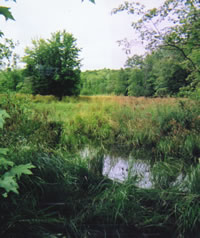 dirt
road. Each puddle was the home of numerous small frogs who
dove for safety as we approached, making splashing sounds
and leaving ever-widening circles of ripples... dirt
road. Each puddle was the home of numerous small frogs who
dove for safety as we approached, making splashing sounds
and leaving ever-widening circles of ripples...
An old beaver pond,
now a wetland,
forms the headwaters of
the Little Miners River,
a tributary of the Miners River.
(Photo by Mary Powell)
We found a pleasant campsite at the location
Michael had proposed--near the banks of an old beaver pond
on the Little Miners River.
I awoke Friday morning to find the dull
headache of the past evening had grown to awesome proportions.
I was glad to have an ample supply of Tylenol and caffeine
which, in time, fixed the problem.
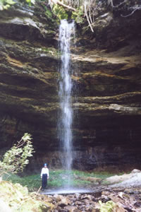
We began the day by bushwhacking to a point
farther down the river where Michael had previously discovered
a small but picturesque falls dubbed Little Miners Falls.
A short distance farther along the river we swerved to the
side and located a ledge of sandstone, a remnant of what had
been a rocky shoreline thousands of years ago when the water
level in Lake Superior was 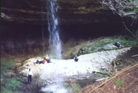 much
higher. much
higher.
Sierra Club spelunkers
enjoy lunch in the
massive, 2000-person
Amphitheater Cave
along the Little Miners River.
(Photo by Gail Staisil)
We donned our helmets and edged along
the wall of rock. Clambering up a slope, rounding a corner
and ducking under a ledge, we were greeted by an awesome sight:
a huge sea cave had been cut into the stone by the ancient
waves.
The arch-opening of the cave was easily
50 feet high and 120 feet wide. The cave was at least 80 feet
deep. The Little Miners River cascaded from the center of
the arched roof into a pool directly in front of the cave
where it then flowed out of sight through the screen of trees
into the valley below. Michael left us there to explore and
enjoy the beauty of the place while he went to pick up Gail
at a prearranged rendezvous.
Peach and gray layers of rock circled the
walls of the cave. The splashing of the river into the pool
was soothing. Everything in the cave was cool and moist. The
whole place was very secluded: walk a few meters downstream
and the cave disappeared from view, obscured by the trees.
Michael returned with Gail in the time he had allotted. We
ate lunch there in the cave, still taking in its beauty.
After lunch we bushwhacked along the edge
of the valley toward Potato Patch campground and a possible
meeting with Rick who had been on our Grand Island trip. We
didn't find him, but we did find some interesting artifacts
from past logging and/or syrup making activities: a sledge
tip, an evaporating tank, and heavy cast-iron grates. 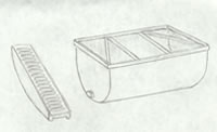
A large, metal vat
and cast-iron grate
found by Sierra Club hikers
south of the Potato Patch
Campground were likely
part of a maple sugar operation
in years past.
(Drawing by Mary Powell)
We ate dinner at Mosquito Beach then bushwhacked
into the buffer zone at the park's edge to camp, selecting
a fairly open area in the beech-maple forest for our site.
Walking around there and setting up camp several people said,
"Do you smell onions?"
By morning we had found our noses were
right: there were patches of wild onions growing in the forest
duff. Gail provided the night's entertainment: she had brought
a brand new Hennessy hammock to try out. We found the set
up, operation, and camping possibilities it presented fascinating.
We got a fairly leisurely start Saturday
morning. Following trails and old two tracks, we moved toward
our rendezvous with Sue whose job had precluded her from joining
us sooner.
We found the remains of what was probably
a recreational lodge site from the early 1900's. Intrigued
by an old wood stove, we tinkered with reassembling it from
the fragments we could find and discussed its possibilities
in a winter camping scenario. Mike U. found a bear trap nearby
and we exploited its photographic opportunities before moving
on.
Sue was waiting as arranged and we 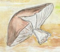 all
hiked to another sandstone bluff, this one overlooking Chapel
Lake. There, Michael had discovered a series of sea caves
on a previous trip. all
hiked to another sandstone bluff, this one overlooking Chapel
Lake. There, Michael had discovered a series of sea caves
on a previous trip.
One of the various
mushrooms spotted in the
Pictured Rocks backcountry.
(Drawing by Mary Powell)
Faced with waiting while a scout party,
composed of Michael, Sue, Bob, and Mike U., assessed the difficulty
of several traverses, I decided to take a swim in Chapel Lake.
What a treat! The lake edge in that area has a sandstone shelf
one to three meters wide a couple of feet under the water.
It made access very easy and provided visual beauty as well.
It was populated by a variety of aquatic
plants and colorful fish. Among waving green, brown, and burgundy
seaweed, pale pink and blue minnows and larger silver fish
were clearly visible against the white rock--an almost tropical
scene.
All thoughts of the tropics retreated rapidly,
however, as I climbed back up the hill after swimming. The
brisk breeze on wet clothes was definitely chilly!
The advance party had returned, having
decided to proceed with the afternoon's exploration as planned.
We had lunch on an overlook with a panoramic view of Chapel
Lake. Then, donning our helmets again, we belayed down the
initial slope. After negotiating a couple 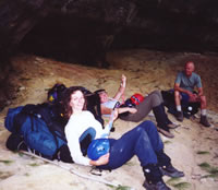 of
difficult turns where there wasn't really room for a person
with a pack on, it was pretty easy going. of
difficult turns where there wasn't really room for a person
with a pack on, it was pretty easy going.
Sue, Lori, and John
take a break while
exploring a string of
little-known caves
high above Chapel Lake.
(Photo by Gail Staisil)
As promised, a series of caves appeared
for us to explore. While they all had the general configuration
of sea caves--a dome ceiling and more or less flat floor--each
cave had its own unique flavor:
- Raptor was very large
with a mostly open entrance and a high ledge on which there
was a nest composed mostly of sizeable sticks. The floor
below it was littered with sticks and refuse which we poked
through, curious as to the identity of the nest builder.
Post-trip research by Sue determined it was likely a raven
or a hawk.
- Down and Out had an entrance
mostly blocked by fallen rubble. Two small openings allowed
us to slip into the dusky cave to find copious evidence
that it had been used for shelter by animals.
- Coal showed evidence of
past human occupation: coal, a worn shirt, and some metal.
There were assorted other caves of varying
size, though nothing approaching the scale of Amphitheater.
One had interesting erosion patterns--colored sandstone layers,
pockets, and columns which we used as a backdrop for pictures.
More post-trip research by Sue disclosed
that most of the droppings in the caves were likely of porcupine
origin. Seems these prickly creatures lead a communal existence
at times.
By late afternoon we had reached the end
of the bluff. We stowed our ropes and helmets and headed for
a campsite in the buffer zone again. This night's spot was
dubbed "intersection camp" for its location at the
convergence of 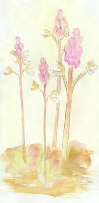 two
overgrown roads. two
overgrown roads.
Sue found native orchids, called coralroots,
in unusually prolific numbers. She neglected to point these
out to the rest of us (she brought them up later in an e-mail)
for fear of enhancing her reputation for eccentricity....
Witnesses to some of her previous wilderness behaviors though
would undoubtedly have thought her pointing out a few saprophytes
pretty unremarkable.
One of many flowering plants--
possibly coralroots--
spotted in the
Pictured Rocks backcountry
and buffer zone.
(Drawing by Mary Powell)
After an evening meal accompanied by much
talk, everyone retired to their respective shelters just before
the rain began....
Getting on the trail around 9:30 the following
morning, we reviewed Mosquito River Falls on the way back
to Mosquito Beach. Though we joked about going where the crowds
were, we saw relatively few people considering it was a holiday
weekend.
Once at Mosquito, we relaxed awhile, walking
in the waves and exploring. We then hiked to Chapel Beach,
stopping at each lookout along the way to enjoy the familiar
vistas: Lover's Leap, Indian Head, Sail Rock....
At Chapel Beach we stashed our gear and
again split up to explore or relax. Gail and Lori joined me
for a swim around the point and into the Cove for pictures.
At the end of the afternoon, we left the
beach for a "20 minute walk" (read more like an
hour) to another buffer zone campsite. This particular trek
seemed to be mostly uphill along old two tracks overgrown
with raspberry brush. When we found a more or less flat spot
on the far side of the park boundary, everyone was more than
ready to settle-in for the night.
Dinner conversations were nevertheless
upbeat, including, among other things, a rather graphic description
of the intricacies of moray eel control. Michael had saved
enough energy for further experimentation with Gail's new
hammock and tarp....
Upon opening my eyes Monday morning, the
first thing I saw was a pair of spiky white balls about two
inches in diameter perched on short stalks--yet another species
of fungus to add to the collection of sketches I'd started
earlier when I'd realized there was an astounding 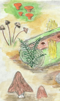 variety
of mushrooms here I'd never seen before. variety
of mushrooms here I'd never seen before.
There was no hope of recalling them all
without pictures or sketches. Their colors spanned the rainbow:
international orange, silvery lilac, bright yellow, burnished
copper, velvety red, and shimmering white.
The Pictured Rocks
backcountry and
surrounding buffer zone
are home to a variety of flora.
(Drawing by Mary Powell)
There was every imaginable shape from dinner-plate-sized
shelf fungi to pale yellow ones that resembled coral to small
round ones of various sizes that looked like marbles scattered
on the moss. There were sturdy toadstools that looked like
thatched huts for leprechauns or fairies.
Mushrooms must be Mother Nature's late
summer decoration as her wildflowers are in the spring....
This trip was no exception. I told myself
it was necessary to return to civilization as my food supply
had dwindled 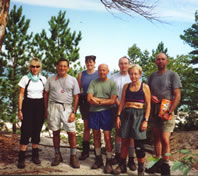 to
a granola bar and a few raisins but it didn't help. We packed
and hiked at a steady pace toward our cars in the Chapel parking
lot. to
a granola bar and a few raisins but it didn't help. We packed
and hiked at a steady pace toward our cars in the Chapel parking
lot.
The Pictured Rocks eight,
minus Sue, take a break
before leaving the lakeshore
for the long drive home.
(Photo by Gail Staisil)
There remained only a parting meal at the
Dogpatch and the long drive home. It had been another really
great trip.
Read
another journal...
|