Looking at this trip from January's perspective--anticipating
the upcoming year's journeys in the warmth of my living room--I
pictured an early spring adventure with soggy ground, dripping
trees, and perhaps the earliest signs of wildflowers.
Pitching my tarp on three feet of snow
during a prior trip in March, I thought, "Next trip,
we'll be camping on dirt again." But Steinbeck's words
are true: "The best laid plans of mice and men oft do
go astray."
As I drove north to the trailhead, surveying
miles of frozen ground and fields covered with old snow, I
wondered if the "stream fording footgear" on the
trip list would really get any use.
The locale for this trip was the Mackinaw
State Forest just off the southwest side of the High Country
Pathway. Arriving late in the evening before the hike was
to begin, I pulled to the side of the last plowed road on
the map and got out to inspect the "jeep trail"
off of which we were supposed to camp for the night.
The snow was less than a foot deep, but
no other vehicle had ventured there, so it was clearly not
a place for a Neon to go unassisted.
A short time later, trip leader Michael
Neiger showed up. He checked the level of the water in the
Black River to see if it was fordable for the next day's hike
and then we succeeded in parking our cars near the beginning
of the untraveled trail.
On a walk down the snowy two track, I found
abundant signs of wildlife--numerous deer and coyote tracks
as well as those of smaller creatures--and little sign of
human presence. Returning to the vehicles I found Michael
already trying out his new sleeping bag beside some small
pines. I retired to the comfort of the Neon's back seat and
slept soundly.
Friday morning dawned hazy but pleasant.
Near the end of breakfast another hiker, Mike Ugoroski of
Flint, showed up. A short time later, Gail Staisil of Midland
arrived. Cars were spotted in strategic places before we drove
to the start of the hike where the HCP crossed a plowed road.
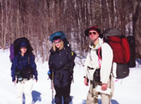
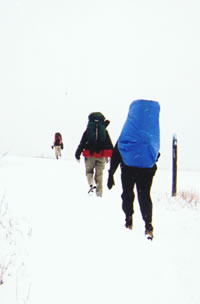
Mary Powell of Flint,
Gail Staisil of Midland,
and Michael Neiger of Marquette
pause while hiking.
(Photo by Michael Ugorowski)
View Gail Staisil's
Photo
Album from this trip
Following the trail we traversed the length
of Rattlesnake Hill, which the HCP brochure describes as a
kamic moraine--a hill formed when debris trapped in a large
glacial crevasse is deposited by the melting ice. It must
have been a VERY large crevasse as the hill covers several
square kilometers and rises about three hundred feet above
the surrounding terrain.
It is covered by mixed forest, breaks in
which afford excellent views of the surrounding valleys and
hills, including Old Baldy, our objective for the next day.
We had lunch in the sunshine on the lee
side of the hill. The snow where we settled appeared at first
to be sprinkled with black dust. After sitting a moment though,
it became apparent that the "dust" was moving. Snow
fleas were out taking advantage of the mild temperature and
sunshine.
Also known as springtails, snow fleas are
tiny, wingless insects that live on the algae, pollen, and
leaf mold found on the forest floor or in the snow that lies
above it. They seemed undisturbed by our presence, but disappeared
toward the end of the meal as clouds covered the sun.
Lunch concluded, we tackled crossing the
Green Swamp. Michael calculated an azimuth to intersect an
old railroad grade in the middle of the swamp and we proceeded
with Gail doing the compass work while he counted pace.
The swamp had a tangled beauty in its snow
cover and an air of being asleep, which invited a return trip
to see it in the summer, lush and green. The RR grade appeared
right where it was expected to be. We followed it across Rattlesnake
Creek and on to the Black River. 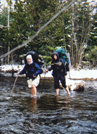
Mary Powell of Flint
and Gail Staisil of Midland
ford the chilly waters of
the East Branch of
the Black River.
(Photo by Mary Powell)
View Gail Staisil's
Photo
Album from this trip
At the river's edge, we pulled our stream
fording footgear from our packs and put them on, doing our
best to avoid any contact between our bare toes and the snow.
We rolled our pants well above our knees. The crossing was
definitely chilly, but not as uncomfortable as anticipated.
Safely across, we set up camp near the bank of the stream
to enjoy its sights and sounds.
We had a beautiful spot for a bivouac.
Ducks came and went on the remnants of an old beaver pond
just upstream. The dark water was framed by snowy banks and
the irregular beauty of varied vegetation. The night turned
out clear and cold with the temperature dropping into the
single digits by morning.
Dawn was awesome: the pale moon and stars
hung in a pastel sky--shades of pink, peach, mauve, and blue.
The landscape was decorated by the crystalline beauty of frost.
We built a small, Indian-style fire on the gravel grade to
warm our fingers during breakfast. By 9:30 though, we were
shedding layers as the sun melted the frost.
The mornings' trek took us through light
forest and open meadows. We took time to lounge in the warm
sunshine and explore the remains of some old buildings. Old
Baldy appeared ahead, a large rounded hill rising about two
hundred feet above the surrounding fields.
It looked a lot like a load of gravel dumped
by some oversized truck, probably another moraine. The sides
of the hill were mostly forested but the top was exposed--hence,
the name. The climb to the peak was strenuous but short. The
view at the top definitely made it worthwhile.
The surrounding fields, valleys, and ridges
were laid out before us in every direction. In one direction,
it seemed we could see for 40 miles. We sat down and leaned
on our packs as we had lunch, still pointing out details in
the panorama before us.
We could see the orderly squares of farms
and lawns, and rows of trees planted by man. There were distant
water and radio towers as well as the glint of rooftops in
the sun. It was fun comparing the view in front of us to our
topo maps--we were seeing the 3D version. We picked out several
areas for future exploration.
After lunch, we ambled down the north side
of Old Baldy, scanning the countryside for elk. We cut cross-country
to a back road that was going in the general direction we
were headed.
One section was lined with POSTED signs
that clearly showed the owner's sense of humor:
No
Poachin' No Trespassin' No Nuthin!
This
applies to friends, enimies, relatives and YOU!
Violator's
(survivors) will be prosecuted
Among other things, the road led to one
of those gas line monitoring stations that look so alien in
the middle of the woods--this one, complete with an array
of solar power panels, like a misplaced space station.
We continued along the road looking for
a draw that would take us over the ridge to the valley where
our cars were parked. Finding it, we began to climb with Michael
giving an ongoing discourse on relating map to terrain. We
saw a number of deer, one of which stood on a ridge above
us and watched as we walked almost 180 degrees around it.
There were several coyote and a few elk
tracks in the snow. Just over the ridge, into the next watershed,
we found a small elk feeding area and decided to camp in the
woods at its edge. With all our chatter, it was unlikely that
any elk would visit, but it was a pleasant place.
We set up our shelters and built a small
fire in the gravel at the edge of the snowy field. It provided
a bit of warmth against the growing chill of evening and a
place to gather for dinner and conversation. It would be easy
to erase all sign of it in the morning. 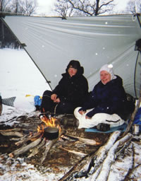
Gail Staisil of Midland and
Mary Powell of Flint
"boil up."
(Photo by Mary Powell)
View Gail Staisil's
Photo
Album from this trip
The night was cloudy, breezy, and cool.
There was light snowfall over breakfast. After the meal, we
packed our things and a short morning's walk brought us to
the nearest car. The end of these trips always seems to come
too soon!
Read
another journal...
Return
to top of page | Return
to home page
In
God's wilderness lies the hope of the world,
the
great, fresh, unblighted, unredeemed wilderness.
—
John Muir 1838-1914, Alaska Wilderness, 1890
Content
Copyright © by Michael A. Neiger
All rights
reserved.
Comments?
Suggestions? Dead links? Inaccurate info?
Contact the
WebMaster at mneiger@hotmail.com
A
MacroMedia DreamWeaver 4 and Fireworks 4 production
|