We have done a number of trips in the past
couple of years at Pictured Rocks, exploring different parts
of the park and seeing it in different seasons. No two trips
have been the same or even similar.
I arrived near midnight at our pre-trip
bivouac near the intersection of H-58 and the Adams Truck
Trail. Awakening the following morning I was surprised at
how different it looked from the way it had in March.
Gone were the ten foot berms of snow with
scrubby bare trees sticking out. Gone were the wide open expanses
of white, and the cold wind stirring up "snow devils."
In their place was a lushly foliaged forest
and cleared areas covered with a profusion of late summer
flowers, mostly chicory, goldenrod, Queen Anne's lace, and
mullein. Though the sun hadn't been up long it was already
hot and dusty.
Trip leader Michael Neiger and I ate a
leisurely breakfast awaiting the arrival of Gail Staisil of
Midland who showed up, as usual, exactly upon the appointed
hour.
After spotting Michael's car at the proposed
end of the trip, we drove down to Beaver Lake to start our
hike.
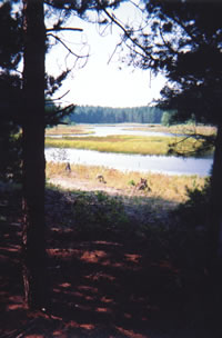
The sandy trail was easy walking and offered
many scenic views of Beaver Lake. A light breeze kept the
temperature almost comfortable.
Numerous chipmunks scampered across our
path and we spotted a sandhill crane wading in the shallows.
At the far end of the lake was a research weir sampling fish
passing through its outlet.
We spent a few minutes talking with a couple
of dayhikers there and savoring the fact that while they were
headed home our trip was just beginning. Leaving Beaver Lake
we headed for the nearby shore of Lake Superior where we planned
to have lunch and a swim.
A short time later we crested a small
sandy hill. The wide beach and the blue expanse of Lake Superior
came into view. There was a brisk on-shore breeze to cool
us and we sank down in the shade at the forest's edge to eat
our lunch.
By the time our meal was over, we had cooled
off considerably. It was mid afternoon with quite a bit of
ground left to cover to reach our planned bivouac.
Swimming no longer seemed like a priority.
Besides, the water's edge was lined with a jelly-like substance
of questionable origin. And there were countless clear pea-sized
lumps of it floating in the waves.
Where the stuff had washed up on the beach
and lain in the sun it had melted to form a band of sticky
goo on the sand. Still farther from the water, this band had
dried to a thin iridescent film in shades of pink and blue.
Michael teased that anyone who would taste
the liquid in a vodka bottle found on the beach as I had done
on Drummond Island should have no trouble swimming in jelly.
Perhaps if it had been warmer and we'd
had a couple days of trail dust and bug bites to rinse off
we'd have gone in, but instead we shouldered our packs and
returned to the trail.
Post-trip inquiry at the Munising DNR office
elucidated the origin of the strange jelly spheres: they contain
a tiny animal called Holopedium gibberum.
According to the DNR handout, "they
are a native zooplankton eaten by cisco, coho salmon etc.
Many of the females are carrying eggs in special sacs on their
backs.
The animal inside the jelly is much smaller
than the glob and is quite clear itself except for food in
the digestive tract and the eggs."
The handout included a picture of the animal,
which is only 1-2 mm long and vaguely resembles a flea. They
definitely don't bother swimmers--as we discovered later in
the trip.
We walked by Trapper's Lake and started
up a ridge that divides the main part of Beaver Basin from
a smaller wetland. As crossing this swamp was not an option,
we traversed the length of the ridge then swung back to climb
to the rim of the basin itself.
We picked up a good supply (read heavy)
of water from Downey Creek, briefly checked out the remnants
of an old camp, and trekked up the long grade to the basin's
rim.
Resting a bit at an overlook, we talked
about exploring or camping in the swamp someday.
The sun had definitely set when we reached
our bivouac in the buffer zone. We set up camp, had a relaxed
dinner, and talked well into the night.
Saturday morning was sunny and warm-very
warm. We began hiking some old logging roads along the edge
of Beaver Basin. After awhile the partially overgrown two-track
began a transverse descent from the rim.
It was like walking in an airy green tunnel
on the side of the ridge; shade dappled with sunshine, a steep
hill on our right, treetops on our left that parted occasionally
to give a glimpse of the valley floor.
When we got hungry we were at the bottom
of the basin near Seven Mile Lake and decided to stop there
for lunch. We waded in the cool water, inadvertently disturbing
some ducks and a heron.
We ate lunch and relaxed in the shade.
Gail found a strange iridescent, pencil-thin worm moving about
in the shallows. It looked like it might make good bait, but
we were without a hook to put it on--or a license to fish,
for that matter.
I tried walking downstream at the outlet
of the lake but fifty meters below the remains of a beaver
dam the loon shit was thigh deep and getting deeper. Not wanting
to swim in it, I returned to the beach. We gathered our things
and got back on the two-track.
Very shortly we began to see, on both sides
of the road, parts of vehicles, remnants of buildings, small
excavations and many bottles and cans--the remains of a lumbering
camp from 50 to 60 years ago.
We spent some time poking around and speculating
on these bits of history before moving on.
At our road's closest approach to Lake
Superior we did a short bushwhack through a hardwood forest,
reaching the lake near Seven Mile Beach campground.
We found the strange jelly all along the
water's edge again, but it was hot and there were biting flies
on the beach, so we went in.
In the shallows the jelly globs felt like
peas floating in the waves, but the water was cool and refreshing
and they were less apparent farther out.
By the end of the swim it was dinner time.
We found a place in the shade at the edge of the beach and
settled in to cook and eat.
Walking along the beach after the meal,
I spoke briefly with a young man who was enjoying the solitude
and waiting for the sunset.
Following a ways behind me, Gail spoke
to him too. After acquiring his entire life history, she brought
him over to introduce him to us: seems he was looking for
people to hike with!
Though our schedules kept him from joining
us for the rest of this trip, he assured us we'd see him again.
He and Michael exchanged e-mail addresses.
Leaving our new friend to contemplate the
sunset, we located the trail that connects the coastal section
of the NCT to the Fox River Pathway and hastened into the
darkening woods to camp in the buffer zone.
By the time we reached the edge of the
park, the sun had set and stars were beginning to appear.
For our bivouac we picked a fern-covered hill with a mixture
of birches and evergreens scattered about.
A shooting star streaked across the sky
as we began to settle in. As it was clear, I decided to forego
putting up my tarp and instead sleep under the open sky.
When I lay down, the ferns were silhouetted
against the stars. I fell asleep with the soft sound of the
breeze and the voices of my friends in the background.
Later that night I made an interesting
discovery: if you leave a sleeping pad in the dark in the
middle of a bracken-covered meadow you'd best be paying attention--because
when you turn around it will have disappeared beneath the
ferns....
Sunday we awoke to another beautiful day
and to a pleasant surprise. Under the ferns there were blueberries
everywhere--handfuls ready for picking and eating.
This finding predisposed us to a leisurely
breakfast: a sip of coffee, some blueberries, a little oatmeal,
some blueberries, etc. Eventually we got packed and made it
to the trail.
We hadn't gone far when we flushed a flock
of grouse and counted fifteen of them altogether. They jumped
into the air individually or in groups of two or three. Wings
whirring desperately, they disappeared into the woods.
The day's hiking was dominated by the Kingston
Plains, an area we were all taken by, but Gail, found it especially
intriguing.
From the DNR trail brochure and her post
trip inquiries of a biologist friend, we gleaned that the
virgin stands of timber in this area were rapidly logged off
in the late 1800s.
Several fires swept through the area after
the loggers left. Fueled by the debris of the logging, these
fires also consumed much of the organic matter in the topsoil,
markedly decreasing its fertility.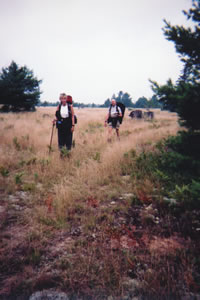
Gail Staisil of
Midland, Michigan
and Michael Neiger of
Marquette, Michigan
hike along the
Fox River Pathway
as it winds its way
through the expansive
Kingston Plains.
(Photo by Mary Powell)
View Gail Staisil's
Photo
Album from this trip
The plains as a whole were never replanted
with trees. What remains is a "stump museum," a
vast expanse of sandy ground scantly covered with grass and
lichens, and dotted with the stumps of the original forest.
There are a few small pines and bushes, but it definitely
doesn't look like the woods are coming back.
There is a lot of beauty in the present
day scene: fields of grass bleached by the sun wave endlessly
in the constant breeze. There are scattered dark pines for
contrast.
The silver-gray stumps of the old trees
have been shaped by the fires and the weather. Some are decorated
with moss or lichens. Others hold arrangements of new plants
in their hollow centers. They are like an endless array of
sculptures in a gallery.
But they have an eerie quality, too, that
keeps calling up pictures of the past, as if perhaps ghosts
of the original forest and its inhabitants still roam there.
The sun was high and the temperature climbed
into the 90's as we walked. We carried extra water, took frequent
breaks, and drank often. A steady breeze kept us from melting....
We ate a light lunch at Kingston Lake,
a shallow sandy-bottomed reservoir surrounded by pines and
edged with reeds and water lilies.
We were on the Fox River Pathway now and
we followed it to Fishhook Lake where we decided to camp among
the red pines on its shore.
The lake is really more of a wetland than
an open body of water: it is thickly edged with sweetgum bushes
and almost covered by lily pads. A few flowers remained on
the latter and the scene must have been spectacular when they
were in full bloom.
To the west across the lake was more of
the same red pine forest that was sheltering us. Others were
camped out of sight there as we intermittently caught the
sounds of children and a dog. Later, the evening was punctuated
with gunshots as if they were engaging in some target practice.
There was time to explore and it was an
interesting place. Gray leeches swam at the water's edge and
farther out were picturesque arrangements of pink smartweed
flowers and pale yellow lilies.
In an open area at the edge of the pines
I found the shell of a map turtle. (See this shell and learn
more about it on the Sheds
and Skulls page on this Web site.)
There was a trio of sandhill cranes hanging
about--we saw them several times. Numerous ducks came and
went on the lake. We watched the sunset and fell asleep to
the calls of whippoorwills.
I awoke in the morning to the peeping of
frogs in the trees around us. They were likely rejoicing at
the light rain that was falling steadily from an overcast
sky. Their mood was contagious.
I contemplated how much simpler life was
here in the bush--where coping with depression means finding
the right spot to lay your sleeping pad and if something's
bugging you, it usually has six legs...
Speaking of which, the mosquitoes were
awake too... They were thinking my tarp was their shelter
and perhaps a restaurant as well! Lit a bit of Pic to discourage
them and boiled up some coffee.
By the time breakfast was over the sky
was clearing. We made our way through the dripping bracken
to the trail.
Finding the trail was not a difficult task
as the DNR apparently employed an individual with an ATV and
a passion for painting things blue to mark it.
Whole small pines were blue. There were
two-foot patches on larger trees. In many places you could
see seven or eight marked trees at a time. There were drops
of paint on ferns and lichens.
In those few places where the marks were
spaced out there were ATV tracks to follow. The only consolation
was that much of this defacement would be muted by time.
We followed this contemporary Picasso (he
had a Blue Period too) across the last of the plains and down
a short stretch of back road.
After some scouting we discovered the "mad
marker" had taken the path of least resistance and driven
his ATV down the edge of the plain instead of following the
original trail along a forested ridge by the river.
We decided to follow the old marks and
had an enjoyable time playing "hide and seek" with
the next couple kilometers of trail. We rejoined Blue Boy
where the plains came close to the river on some rolling hills.
While taking a break near the end of this
road, we walked down a narrow path--probably the work of fishermen
or hunters--and found the Fox River winding through a brushy
valley.
It was an eight-foot-wide ribbon of water
bordered entirely by overhanging bushes. There was a narrow
wooden bridge spanning the stream--so low that it was touching
the water. 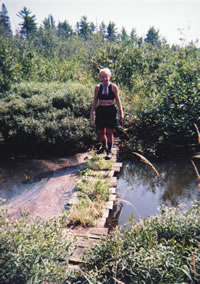
Mary Powell of
Flint, Michigan
examines an
old foot bridge
across the
West Branch of
the Fox River.
(Photo by Mary Powell)
View Gail Staisil's
Photo
Album from this trip
A variety of plants had sprung up between
its boards. We had to try it out. It was tippy but supported
our weight. Being that close to water on a warm day presented
a strong temptation.
I gave in, removed my boots and lowered
myself from the bridge. The water was over four feet deep
and deliciously cool. The bottom and sides of the stream were
lined with branches as if the river had made a nest for itself.
After taking a few pictures, we returned
to our packs and hiked on 'til late afternoon. We found a
place to camp in a lichen covered clearing on a hill by the
river.
Some big pines offered shelter from the
storm that was approaching. We ate the last dinner of the
trip together before the rain began.
Gail ate up her "leftovers" (open
packages that wouldn't keep well) while I decided that tomorrow's
lunch looked better than the dinner I was "scheduled"
to eat.
We discussed the need to move to lower
ground if the thunderstorm came close. Then we retired to
our shelters and fell asleep watching the trees being intermittently
silhouetted by distant lightening.
Tuesday morning was pleasantly cooler.
We hiked from our bivouac to the Stanley Lake campground over
a series of moraines covered with mixed forest.
The campground is closed, but the cleared
areas provide beautiful vistas of the lake. We watched a heron
there and sandhill cranes could be heard in the distance.
We used up the last of our film at the
dam on the outlet of the lake, then reluctantly walked to
Michael's car a few hundred meters up the road. A trip's end
is always bittersweet.
Read
another journal...
|