Saturday dawned cool and overcast. Four
of us met for breakfast at a small restaurant/general store
on Hwy 17: Gail Staisil of Midland, Sue Schenk Drobny of Marquette,
trip leader Michael Neiger of Marquette, and myself.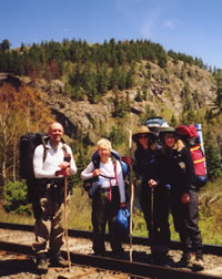
Michael Neiger of Marquette,
Mary Powell of Flint,
Sue Schenk Drobny
of Marquette,
and Gail Staisil of Midland
pause along the ACR tracks
in the Agawa Canyon.
(Photo by Gail Staisil)
View Gail Staisil's
Photo
Album from this trip
After the usual breakfast of pancakes we
drove to Frater Road, parking one car near the tracks where
we planned to debark from the train at the end of our journey
and the others at the Towab trailhead where we would begin.
As we drove, I wondered if we would achieve
our rather ambitious objectives for the trip: to see Agawa
Falls, visit the top of Bridal Veil Falls, climb Kwagama
Mountain, see the wreckage of a bush plane, and hike to Lady
Evelyn Falls.
I wondered how you feel after more than
a week of hiking this rugged backcountry. I was remembering
that the Algoma Central Web site says that Canyon Station
(definitely on our itinerary) is "only accessible by
rail...."
Thick area--brush will
limit visibility to three feet or less: watch your feet
as they tend to disappear into holes between the underlying
rocks and logs.
Open area--visibility will
be OK but be prepared to be lashed by tag alders and tangled
in the heath.
Grissant--French word meaning
"make sure you have a firm grip on something at all
times because your feet are not going to stay where you
put them."
Crabwalk--means of getting
up slopes greater than 60 degrees or so.
Outlet--definitely not
a mall: the usually swampy place where a lake is drained
by a river or stream.
Wet your pants (or shirt
or bandana)--technique for keeping one's body cool enough
to function.
Getting close--meaningless
term indicating the objective is somewhere between a hundred
meters and a kilometer or two away, potentially with major
obstacles in between.
After a final check of our gear and a lot
of commentary about the weight of nine days worth of food,
we started off on the Towab Trail, which runs along the Agawa
River to Agawa Falls.
The woods we passed through had the impending
lushness of early spring--lots of buds, a pale haze of new
leaves and coils of fern just poking through the duff on the
forest floor. Trout lilies and trilliums were out. We saw
assorted warblers, brilliant orange orioles and inquisitive
humming birds.
There were a few people too: three men
with a dog and a couple speaking German were on their way
out. A young man wearing jeans and carrying a large pack hurried
past us on his way to the falls. We had lunch at Burnt Rock
pool, just beginning to relax and get used to each other's
company.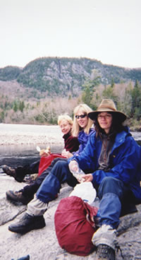
Mary, Gail, and Sue
enjoy lunch at Burnt Rock Pool
along the bank of
the Agawa River.
The north wall of the canyon,
visible in the background,
is a foothill of Kwagama Hill.
(Photo by Mary Powell)
View Gail Staisil's
Photo
Album from this trip
We explored a bit, commenting on the many
signs that the spring runoff had been intense this year. We
saw the first of many huge (3' x 4' x 25') timbers left from
lumbering days. This one had been washed well back into the
woods by the spring torrents.
Sometime after lunch the sky darkened,
the breeze picked up a bit and an intermittent drizzle began
to fall. We got our first taste of "grissant"--the
rocks, the roots and the mud were slick. We passed some young
men huddled under a tarp hoping the rain would stop.
Michael asked Sue if she was having fun.
After a long contemplative pause she allowed, "Some..."
By 5 pm were damp and thoroughly chilled.
Encountering a campsite, we decided to stay the night there,
though we had hoped to make it to the falls. We set up our
shelters and built a small fire. That and a warm meal definitely
lifted our spirits.
The young man in jeans we had seen earlier
hurried by saying he hoped to get back to the trailhead before
dark as his tent was leaking and he had no raingear... We
invited him to stay by the fire and to spend the night but
he declined.
As we prepared to turn in Michael said
he was glad to have one of the easy days out of the way...
Sunday morning we awoke to chilly air,
gray skies and steady rain. We ate a leisurely breakfast hoping
the rain would stop. It finally did and we packed wet tarps,
donned damp raingear and hiked through the sodden landscape
with its assortment of things grissant underfoot.
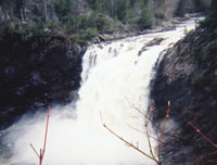
By noon the sky had lightened a bit. Agawa
Falls was definitely worth the walk. The entire river spills
over a 90-foot-high precipice into a rocky gorge.
We spent some time taking in the views
from below the falls, then climbed to the top and ate lunch
with a spectacular view of the gorge below, the mist on our
faces and the thunder of the falls in our ears.
Some canoeists, their small boats colorful
against the dark water, peaked around the edges of the gorge
to get a view of what they'd portaged around.
Starting to hike again after lunch, we
promptly ran into a sign that said, "End of Trail."
Michael said we had finally reached the REAL trailhead and
could finally get started with our adventure...
We bushwhacked on up the river and camped
that evening near another gorge where the river narrowed and
rushed between steep walls of rock.
On a walk after dinner I saw numerous piles
of moose droppings and sat for a while looking over a swampy
plateau hoping to see one, but had no luck.
Back in camp, Michael joked that he had
talked to Lucy (presumably one of the resident moose) about
putting in an appearance on this trip. It didn't happen though.
We saw lots of droppings and tracks were
so plentiful in some places that the ground had a barnyard
appearance. The only moose sighting, however, was a tentative
one made by Michael several days later--a dark shape several
hundred yards away along a power line.
The evening was cool and we built a small
fire on the sandbar and talked 'til the stars came out. Just
before retiring we heard the very distant sounds of one of
the Algoma Central freight trains. Searching the darkness
we saw its light--a pinpoint moving through the darkness across
a valley miles away.
Monday morning the sky had cleared and
it promised to be much warmer. 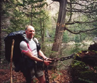
Michael tugs on
a huge, heavy chain
still attached to
old growth logs used to
form a log boom
that contained rafted up logs
on the Agawa River
during the logging era
years ago.
(Photo by Gail Staisil)
View Gail Staisil's
Photo
Album from this trip
As we proceeded along the Agawa river,
Michael spotted a small white object about 25 feet up on the
trunk of an old tree. There were blazes cut into the bark
below it. Scanning around he spotted another maybe fifty yards
away--and then another and another--in a line roughly following
the river.
We continued to look for them and found
one on a fallen tree permitting a closer inspection. They
were ceramic insulators, tightly wired to the trunks of the
trees. Hexagonal and a little over two inches across, they
had a center hole which most likely was for a telegraph cable
to pass through.
Following the trail of insulators we soon
came upon the remains of a lumber camp and spent some time
exploring it and imagining it as it had once been.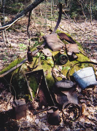
A wide variety of artifacts
were found at the site
of an old logging camp
located along the south shore
of the Agawa River,
upstream of Agawa Falls.
(Photo by Mary Powell)
View Gail Staisil's
Photo
Album from this trip
There were plenty of clues--artifacts,
trash piles and remnants of buildings. Chains of assorted
sizes, timbers and cables were everywhere. We took pictures
of some of the most interesting pieces and then moved on,
planning to look up some of the manufacturers' names upon
our return to civilization.
We bushwhacked around the Spire, a prominent
landmark, and headed for the railroad tracks. It was rather
difficult going with a lot of climbing and descent, thick
brush and sheer bluffs to be skirted.
On the last slope up to the tracks, one
with about a 65 degree slope, Sue attempted to climb through
a fallen pine and got hopelessly stuck. After chopping her
free with his bowie knife, Michael teased her unmercifully
afterward about needing a high angle rescue...
Once on the tracks the going was easy if
somewhat monotonous. We added bloodroot and chicory to our
wildflower list. Despite the growing heat there were pockets
of ice left from winter in sheltered nooks and crannies among
the rocks.
At one point a curious woodchuck studied
our progress a while. With no forest to shade us and the sun's
heat reflecting from the rocks, it became necessary to drink
often and wet articles of clothing to keep from overheating.
Around lunch time we reached the trestle
which carries the tracks across the Little Agawa as it flows
down to meet the main river just below. There is a series
of stair step falls there and we checked out a few of them.
The southbound passenger train, only about a half an hour
late that day, rolled past as we ate lunch.
After eating we continued down the tracks
and reached the trestle that crosses the Agawa itself about
the time one should be thinking about setting up camp. There
is a somewhat flat area near the bridge and we decided it
was home for the night.
After setting up our shelters Michael and
I explored a bit and found a beautiful little falls spilling
into a slot canyon. Michael decided to climb on up and check
out our prospects for reaching the east rim of the canyon
the next day. I returned to camp and a brief dip in the river.
Later we ate dinner by the river watching
the sun set prematurely as it was blocked by the west wall
of the canyon. Mosquitoes and black flies buzzed about at
minor nuisance level.
After the meal we all walked up to have
a look at the next day's objective: Bridal Veil Falls. It
is an impressive falls.
The creek drops 225 feet over the edge
of the canyon, splashing on ledges about 3/4 of the way down
giving it the look of a veil draping to the floor. There is
a large dark pool of water at the base of the falls. That
and the surrounding dark rock contrast nicely with the falling
water which shines white in the sunlight.
Our plan being to camp at the top of the
falls, we scouted the edges of the canyon wall with binoculars
looking for open areas.
Returning to camp we settled in for the
night....at least some of us did.
I had been reading for about twenty minutes,
enjoying the peaceful sounds of the breeze and frogs singing,
when there was a tremendous clattering followed by a whoop
and then laughter from the direction of Sue's tent.
Michael, it seems, had not been in a reading
mood. He had sneaked up the trail toward the tracks and stealthily
gathered up a collection of pop cans--each containing a few
pebbles and strung together on a rope--left by some previous,
not-too-thoughtful campers.
Holding them carefully to keep them quiet,
he had crept up beside Sue's tent and dropped the bundle about
a foot from her head as she was drifting off to sleep. Sue
has a great sense of humor but she did indicate that some
sort of retribution was in order....
Near morning there were sounds of movement
from Michael's hammock followed by an exclamation, "Get
the Hell out of here!"
It seems Mother Nature's sympathies were
with Sue and She'd sent a mouse to visit Michael. He was awakened
by its stepping on his forehead and had had to get up to get
it out of his hammock.
In the morning Sue commented that while
she appreciated Mother Nature's effort on her behalf, it wasn't
over yet...
Tuesday turned out to be a strenuous day
of hiking rewarded by unbelievably beautiful scenery.
We ate breakfast in a thicket by the river
watching the sunlight chase the shadows down the canyon wall
as the sun came up. Picking up our packs we walked a short
distance to the little falls we'd found the night before.
It was already getting hot and we spent
a refreshing hour or so wading and climbing around the falls.
We took pictures and Michael took a brief inadvertent swim.
After getting dry we sorted our gear and
cached what we wouldn't need for the next 48 hours to make
the climb of the canyon wall a little easier.
Somehow by this point in the trip we had
all developed nicknames. I think Sue had a lot to do with
originating them, but we all participated and they added an
element of humor to our trail conversations.
The following factors probably contributed
to Michael's designation: 1) Chilly weather which resulted
in our borderline hypothermia the first day, 2) Excessive
time spent peering at maps and looking at the surrounding
s with a quizzical expression, 3) His writing "July 2nd"
instead of "June 2nd" as the trip end date on our
camping permit, and 4) The fact that "we're getting close"
had such variable meaning. Michael was renamed "Shackleton"
after the ill-fated Antarctic explorer.
Sue wore a hat on this trip that may once
have belonged to Indiana Jones. She told entertaining stories
that involved participation in stereotypically male activities
such as chewing tobacco--so Michael started calling her "Joe."
Gail, on the other hand, has an uncanny
ability to pull fashionable, unwrinkled clothes, gourmet foods
and an amazing array of technical equipment from her tiny
pack. When she set up to cook, she would occupy less than
a square yard of space and everything remained neat throughout
the meal.
We started calling her "Martha"
after Martha Stewart who always has the "right stuff"
and right technique for whatever she's doing. Ms. Stewart's
well known phrase, "It's a good thing," became a
part of our banter too. It could be used sincerely in regard
to beautiful sunsets, awesome vistas and peaceful campsites.
Or it could be used facetiously--as in being faced with the
prospect of crossing a stretch of dark ooze to dip a bottle
of brackish water and saying, "Is this a Good Thing?"
As for me, I'm kind of into do-it-yourself
projects. After I'd explained the making of a second or third
piece of equipment in response to Sue's queries, she said,
"You're a regular Heloise of the woods...." Heloise
stuck.
Around noon on Tuesday "Shackleton",
followed closely by "Martha", "Heloise"
and "Joe", began the ascent of the east rim of the
canyon.
We took turns crab-walking up stretches
of slope so that no one would be on the receiving end of dislodged
rocks and debris. On reaching the top we marked the draw we
had come up, as Michael had found the evening before that
it was the only way back down.
We had lunch at the top of the falls we'd
explored the bottom of earlier. We discussed possible names
for it and settled on "Slot Canyon Falls"--though
Sue suggested a spelling change that might appeal to prospective
male hikers....
After lunch we started a bushwhack that
would take us to Bridal Veil Falls.
Rather than cut a long azimuth to a small
objective (the falls), Michael proposed doing shorter legs
to three intervening lakes, thereby getting to see some interesting
backcountry on the way.
It was an afternoon of difficult travel
and a fascinating variety of bush. There were high angle slopes
with tangles of brush and many fallen trees. There were swamps
around the lakes and streams.
Each of us had our own cloud of bugs which
merged into one large cloud whenever we paused close together.
The lakes we traveled to had no names on the map.
The first I'll call Old Beaver Lake as
it had been much larger at one time when beavers were active
there. It had a broad border of grass with soggy black soil
underneath. There was a rocky peninsula at one end, beyond
which was a wetland that had once been part of the lake. Frogs
sang loudly there.
At the opposite end, near the outlet, was
a large abandoned beaver lodge. Passing it, we followed the
stream for a while before beginning a bushwhack to the second
lake which I'll call Railway Falls Lake.
Looking across it we saw a vista that was
definitely postcard material: a 40-foot falls dropped into
it from Railway Lake above.
The third lake, while pretty, was not
exceptional. Steep, rocky, forested slopes ran right down
to the water's edge. The outlet area was a swamp, the worst
of which we bushwhacked around.
When we located Railway Creek again Michael
decided to do a recon to find the easiest way to the top of
the falls and to locate a possible bivouac area. We hadn't
seen a flat spot large enough to lay down in for several hours.
While Shackleton was away, Martha, Heloise
and Joe decided to find out what would happen if he came back
and found them gone. The plot was foiled, however, when he
returned by a different route....maybe next time....
Working our way down the creek, we came
to the stellar camping place Michael had found.
He and Gail put up their hammocks within
a few meters of the falls with an awesome view over the rim
of the canyon. Sue and I bivouacked in a nearby semi-flat
space in the woods.
We all gathered for the evening by the
edge of the falls. The canyon spread out before us and we
could study its vast grandeur: the ribbon of river in shades
of brown varying with its depth and the opposite canyon wall
with gnarled trees clinging to every small ledge.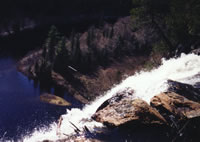
The 250-foot-high
Bridal Veil Falls
as viewed from above.
(Photo by Sue Schenk Drobny)
View Gail Staisil's
Photo
Album from this trip
Railroad tracks followed the river on one
side, power lines on the other. Directly below and across
from us were the observation area we'd been in the night before
and the trails leading up to it. At the limit of our view
upstream we could just see the manicured lawns of Canyon Station.
In the other direction a small stream
tumbled down the opposite wall in a series of falls just visible
through the trees. We could see minute details like a swimming
beaver and the trails left on the river bottom where a canoe
had disturbed a sandbar.
Cradled in the roots of a large pine,
I watched individual water droplets as they were launched
and fell, continually changing shape, toward the rocks below--a
somewhat dizzying and hypnotic experience. Now and then the
breeze would carry some mist up to us.
We watched a bank of clouds change shape
and dissipate, leaving the sun to set in an almost clear sky.
Venus and Jupiter appeared as the twilight deepened.
Around 11:15 we heard the distant squealing
of brakes and muted rumble that signaled a southbound freight.
It grew louder and finally rushed by in the darkness below,
its light reflecting from the canyon walls at the curves,
its wheels clicking and clacking on the tracks.
We fell asleep soon afterward lulled by
the steady roar of the falls.
We returned to our falls-side perch for
breakfast and watched the sun light up the west side of the
canyon--gazing in the direction of our next objective, Kawagma
Mountain, hidden some miles behind the hills on the far rim.
It was hard to leave when Michael said,
"Take a good last look; we won't likely be back here
soon."
We finally turned and followed him as he
moved into the woods. Not wanting to just retrace our steps,
we loosely followed the east rim of the canyon.
Morning break found us taking in another
view of the canyon from an open rocky ledge. We had returned
to Old Beaver Lake by lunchtime and after the meal we bushwhacked
to the draw we'd marked and scrambled down.
By the time we reached the bottom, another
dip in the creek seemed in order. Refreshed, we reassembled
our gear and headed for Canyon Station.
Canyon Station is a park maintained by
the Algoma Central Railroad. Tour train passengers can debark
there for a couple of hours and stretch their legs by walking
the trails to the three waterfalls or by climbing to an observation
platform 250 feet above the canyon floor.
There are picnic facilities and a souvenir
car. The park's crew is headed by Kevin whom Michael knew
from previous trips. As we approached the station he came
out to talk.
He related how the crew had come up early
this year to get the park in shape for the summer, but the
late snows and heavy flooding had complicated the job.
He shared tidbits of canyon history--like
the story of Spooner who was injured years ago working for
the railroad and lived out his life, alone except for a big
white dog, in a cabin a few miles upstream. He told us to
keep an eye out for Spooner's wooden leg which was lost when
he drowned in a river crossing and had never been recovered.
Another character from the past was Bucksaw
Bill who also lived upstream and was the canyon's law enforcement
for some time. As we moved toward Otter Creek Falls to climb
the west side of the canyon, Kevin showed us some stone stairs
laid hundreds of years ago by Native Americans.
And he told us that here at the station
you could watch the moon rise three times in one evening.
He'd done it himself. Climb the stairs to the observation
platform and watch it rise there. Return to the bottom of
the canyon and watch it rise over the east rim. Then paddle
across the river and watch it clear the east wall again.
It occurred to us that perhaps there were
nights when the crew had a little too much time on their hands....
Kevin appeared to have more stories, but
Michael was anxious to get back into the bush and after a
hasty appreciation of Otter Creek Falls and a friendly farewell
to Kevin we followed him up the draw....and up....and up....
By the time we reached the top, Sue had
pulled a muscle and was limping significantly.
As there was a shortage of premium bivouac
spots in the immediate vicinity, we ended up camping in the
cleared area near some power lines.
While the proximity of so many potentially
unruly charged particles caused some apprehension, the site
did have several advantages: 1) We were there and the sun
was sinking, 2)The breeze in the clearing thinned the black
flies a little, and 3) There was a corridor of unobstructed
view where we could watch for wildlife.
Scanning to the north as we ate our evening
meal, Michael was sure he saw a moose. Some of us were reluctant
to count a dark shape moving at the limit of binocular range
as a moose sighting but he was not to be deterred...
We then discussed hanging a hammock between
the power line poles, but decided that might be excessive
temptation of fate and found accommodations a little farther
from the wires.
Thursday morning was cool and foggy.
We made a fairly leisurely start, proceeding
along an ATV trail that passed a couple of cabins on small
lakes. The trail became less distinct, then became intermittently
part of a streambed. We followed it past an abandoned beaver
pond with so much dead timber that it looked like there'd
been an explosion.
At lunch time we were near the intersection
of this "road" and a creek. We ate in a breezy clearing
filled with trout lilies. A white throated sparrow sang repeatedly
that we were in "Canada ..Canada...Canada..."
After the meal we again sorted our gear,
taking only what was essential and caching the rest to reduce
pack weight. Michael said he was glad we were finally getting
to the challenging stuff. The rest of us were wondering how
much more challenging it was going to get...
The afternoon lived up to Shackleton's
expectations. It was well over 90 degrees, but thick brush
and black flies made long pants a necessity.
An hour or so into the trek what little
we could see of the surrounding terrain wasn't matching the
map. A light rain began to fall as we emerged temporarily
from the thick stuff onto a meadow/wetland. The tops of the
surrounding hills, just visible over the trees, were pretty
nondescript. We dug out the GPS hoping it would enlighten
us.
Several days earlier, wanting to get a
fix on the location of the old lumber camp, we had gotten
it out. Despite the relatively open area there, it had been
unable to acquire a signal.
We sat on our packs chewing damp granola
bars and waited while it searched for satellites. After a
few minutes it told us we were right on course--just a little
overly optimistic about our progress.
We continued to bushwhack, crossing rocky
hills covered with thick stuff and the intervening lowlands
covered with swamp. In one of these lowlands, Shackleton and
Joe in the lead had just crossed a boggy area and disappeared
into the brush when Martha suddenly dropped down in front
of me.
Her right foot had broken through and she
was resting on her elbow with her right leg sunk up to the
hip in the ooze. She dispensed immediately with all decorum
and expressed her heartfelt sentiments at this turn of events....
We took off her pack and began to extricate
her from the mess. From the bush beyond the bog Joe called
back, "What's the hold up?" I replied that we were
OK, but it was going to take a few minutes to get going.
On her feet again, Martha looked a bit
bedraggled. Her once crisp white shirt had large splotches
of black ooze and several pounds of mud clung to her leg.
Never one to carry any extra weight and
mindful of Michael's admonition that not one drop of the four
liters of water we were carrying (because there was no water
at the top of the mountain) was to go anywhere but in our
mouths, she decided to "wash up" with the green/brown
liquid from a pool nearby. This effort did remove the bulk
of the slime, leaving her with just the black stains, the
soggy boot and the "eau de swamp."
We slogged onward. Michael said we were
contouring around the hills, but I could swear 90% of the
afternoon was uphill....
Finally we came to the base of the hill
he identified as Kawagma and started to climb in earnest.
The drizzle had ended and it was hotter than ever.
Breathing harder from the effort, I found
a headnet was essential to keep from inhaling excessive numbers
of blackflies. Occasional choking coughs from the others told
me I wasn't the only one having that problem.
After a very long forty minutes or so,
the brush thinned out and the angle of the slope decreased
slightly. Shackleton said this didn't look familiar....not
a popular remark with the crew! We proceeded over several
small rises, finally coming to one with a large outcropping
of lichen-covered rock.
Climbing up on it we saw the surrounding
back country spread out before us. The curve of a bay on Lake
Superior sparkled in the distance. We had made it to the top!
Though the sun was shining, a bank of clouds
appeared to be on a collision course with our hill. We retreated
from the summit to a lightly forested depression about thirty
feet below and hastily set up our shelters.
As we tied the final knots there was a
flash of lightening followed immediately by thunder. The woods
filled with mist and the rain began. Under our tarps we changed
to drier clothes and boiled up our evening meal. Life was
good again.
By the time we finished eating the storm
had passed. Michael found a good tree for our bear hang--a
job that was taken seriously that evening as there were several
piles of ursine scat nearby.
The mists cleared and we returned to the
summit to soak up the view. There were shreds of cloud above
and below us. As darkness came colors faded leaving only the
silhouetted contours of the land. Finally there were just
a couple of very tiny distant lights on boats in the bay.
Lying in my bag next morning, not yet fully
awake, I thought, "Sounds like the hamster's out of the
cage again... " Then it came to me that I haven't had
a hamster for many years.
Opening my eyes I saw a small rodent about
eight inches from my face, matter-of-factly consuming the
small piece of pack towel I'd been using to pad one of my
shoulder straps.
I watched him without moving for a minute
or so. He was large for a mouse and brown, not gray. His tail
was short too--less than half his body length.
He stared back at me and continued to sample
the towel, turning it in his forepaws to get the tastiest
bites. When I moved he froze for a few seconds then scampered
off. I picked up the cloth he'd been chewing--it looked like
purple Swiss cheese.
It was probably a good thing I hadn't kept
any snacks out that night, as there might have been many more
visitors.
It was another cool foggy morning.
We climbed up for a look at the view, but
it was gone: we were on an island in a sea of cloud. Hoping
the clouds would dissipate, we ate breakfast, read and poked
around the remains of an old fire tower blown down by the
winds many years ago.
Sue collected some bits of quartz for
a friend who makes jewelry. Late in the morning the wind carried
the last of the clouds away and the view we had come for lay
before us again.
Saw-toothed ridges ran at an angle toward
the north, roughly parallel to Lake Superior which glinted
brightly to the west.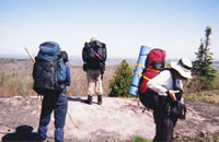
Sue, Michael, and Gail
check out the view from
Kwagama Mountain,
elevation 2050'.
(Photo by Mary Powell)
View Gail Staisil's
Photo
Album from this trip
Geology texts say that in this area layers
of sedimentary rock were crushed by the weight of the water
in an ancient sea 'til they tilted and cracked. They were
then eroded repeatedly by glacial ice which also deposited
the gravelly debris that filled the valleys. We could see
the worn edges of the rock layers with their forest cover
stretching into the distance.
Agawa Canyon was hidden by the hills to
the east, but at the limits of vision we spotted a tower and
took a bearing on it so we could look for it as we headed
back to the canyon. Finally, though reluctant to leave the
view, we started back down.
While not easy traveling, the trip down
from Kawagma was not as arduous as the trip up. We ran one
long azimuth to a lake and then another to hit a "road"
that intersected the creek where our gear was cached.
Any resemblance to a road there was purely
coincidental: it was a lot of rocky creek bed surrounded by
swamp. Moving by compass in the direction the road should
have gone, the scenery eventually began to look familiar.
Just in time for lunch, Michael announced,
"I've got 'em." He had unerringly returned us to
our cached equipment. Nice job Shackleton!
An easy afternoon's hike brought us to
an old gravel pit with a stream nearby: luxury accommodations--flat
ground AND water! We set up our shelters around the edge of
the pit then soaked in the chilly water of the stream and
relaxed.
For the evening meal we gathered in a small
circle to share conversation and the smoke from Pic burners.
Actually, the bugs were at a tolerable level--you could put
up your headnet to eat without consuming or inhaling too many.
The chill of late evening thinned them further.
The sun set in a blaze of red-orange beyond
the trees. It was a clear night and the stars put in their
appearance. Toward morning there was a small slice of peach
colored moon. The temperature dropped drastically and we awoke
to patches of frost in the low areas.
Michael was up early. He said the hammock
got chilly and he'd been buzzed by a hummingbird interested
in the red liner of his sleeping bag...
With one full day of the trip left we elected
to walk the back trails and tracks to the place where the
train stops for clients of Windy Lake Lodge, leaving Lady
Evelyn Falls and the bush plane for another trip.
There is a trestle where the Black Spruce
River joins the Agawa and a knob of rock Michael thought might
be a good camping spot--affording us a view. Alternatively,
there are some falls on the Black Spruce--perhaps we would
camp there...
The walking was easy but the temperature
rose steadily until we were refilling our water bottles at
every creek. The country is ruggedly beautiful and with the
clearings provided by the tracks, the power lines and the
back roads we were able to see and appreciate it.
The canyon walls are near vertical rock
faces in colors ranging from dark gray/black to pink. Huge
trees cling in precarious places. Small streams are everywhere,
spilling from ledges, running down the rock faces, trickling
through cracks and draws. Forest alternates with wetlands.
We passed the cabins of Spooner (no sign
of the missing leg) and Bucksaw Bill. We lunched by the Agawa
and talked about fording it to travel the old logging roads
on the east side on a future trip. We approached mile 122
1/2 in the late afternoon.
In the last hundred meters before the tracks
we came upon the Shuttle Vehicle of the Year...a derelict
truck decorated with camo paint and political stickers. There
was a prominent bullet hole in the driver's side windshield.
We took some pictures just for fun.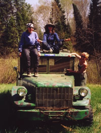
Gail, Sue, and Mary
inspect this year's
shuttle vehicle
located near the
Agawa River.
(Photo by Gail Staisil)
View Gail Staisil's
Photo
Album from this trip
It was time to look for a campsite. Gazing
at the rock knob rising more than a hundred meters above the
tracks, we decided it was an objective for a future trip.
Even Black Spruce Falls, another half-hour walk, seemed too
far away.
We settled on a relatively flat area between
the tracks and the Agawa River. We rested, swam in the river
and explored the immediate area. I walked up to see if the
falls were as pretty as I remembered from the previous year.
Sue investigated the repeated cacophony
of crow calls we heard while setting up camp. She located
their nest high on a rock face across the Agawa. With binoculars
you could see there were three young that appeared to be near
fledging. They created an amazing racket each time a parent
returned with food.
We arose lazily in the morning and gathered
our things, marveling how light the packs had become.
The train that would pick us up was not
due until early afternoon. We crossed the trestle and ambled
up the trail to the series of falls on the Black Spruce. Each
has its own personality.
The first is a churning chute where the
river passes through a narrow crack in the bedrock. The second
is a pair of pools with a falls dropping between them. The
third is composed of many little falls as the river spreads
out while dropping over a much eroded rocky incline.
We read or climbed on the rocks and waded
in the pools. We snacked on what little was left in our packs--then
headed back to wait for the train.
Back at the tracks we found a group of
fishermen from the Soo with a small mountain of gear. They
were eager to recount their adventures and it occupied the
time we had to wait for the train. In addition to fishing,
they had worked at stocking some lakes and they had consumed
an amazing amount of beer in the process.
The train appeared less than half
an hour behind schedule. We loaded our packs and climbed aboard
for the ride to Frater Station. We stood in the open areas
between the cars watching as the sights we had seen on foot
rushed by in reverse order. We talked about the next time....because
we will be coming back!
View Gail Staisil's
Photo
Album from this trip
Read
another journal...
Return
to top of page | Return
to home page
In
God's wilderness lies the hope of the world,
the
great, fresh, unblighted, unredeemed wilderness.
—
John Muir 1838-1914, Alaska Wilderness, 1890
Content
Copyright © by Michael A. Neiger
All rights
reserved.
Comments?
Suggestions? Dead links? Inaccurate info?
Contact the
WebMaster at mneiger@hotmail.com
A
MacroMedia DreamWeaver 4 and Fireworks 4 production
|