|
On a pleasantly cool evening in early April my carpooling
partner, Milton French, arrived at my place and tossed his
pack into the back seat of my car.
We climbed in immediately and headed for the expressway:
we had dinner plans with Gail Staisil of Midland whom we hadn't
seen in a while. She was unable to make this trip but we wanted
to catch up on the intervening months and make some tentative
plans for our next trip as it is important to always have
one to look forward to!
I-75 was busy as usual, but traffic was flowing along about
5 mph over the speed limit so we arrived at the restaurant
only a few minutes late. Gail was there as planned and the
evening unfolded pleasantly with good food and stories of
what we'd been up to since January.
Around 9 p.m. the pressure of upcoming obligations exceeded
the cohesive power of good company and we said our good-byes.
Gail went to pack for an out of town trip and Milton and I
headed north again.
We exited I-75 at Gaylord, zipped across M32 and soon were
hunting for the rural intersection that was the appointed
bivouac. Trip leader Michael Neiger of Marquette had laid
out a plan that would take us northeast across the plot of
state land that surrounds the Jordan River Pathway.
Like most of his trips it would include a lot of bushwhacking
though we would see some segments of the pathway too.
Arriving at the designated corner we saw Michael's red Ford
Explorer parked along the east side of the road along with
another car which presumably belonged to the other expected
early arrival, Alex Chard of Lansing. Bill Host of Grand Rapids
and Mike Ugorowski from Flint planned to be there in the morning.
When we stepped from the car the night air was chilly and
a light frost covered everything. We scanned our surroundings
looking for the others and for a comfortable place to sleep.
An almost full moon gave us considerable light but there
were no tarps or bivys in sight.
I selected a spot for my sleeping bag beneath an ancient
apple tree atop a small rise not far from the car. Milton
settled nearby but left enough space between us so my snores
wouldn't keep him awake. The remnants of last summer's grass
made a luxurious mattress and sleep came easily.
Milton wrote: We
arrived at the trailhead about 11:30 p.m. The moon was just
past first quarter and bright with a clear sky. We setup
camp in a field just east of the cars. After the moon set,
I looked at the beauty of the night sky. The Milky Way was
faint but clearly visible. There still was significant sky
light. I estimated close to magnitude 6 skies.
We awoke next morning before the sun was fully up. The entire
sky was suffused with a soft pink light. As there was still
no sign of Alex and Michael, we decided to have breakfast
near the car.
By the time my coffee was brewed, I saw Michael waving from
the top of a nearby hill--should have known he'd go for the
view!
Milton wrote: We
saw Michael and Alex some distance away on a hill. When
we got together, he asked why we hadn't come over to join
them when we had arrived last night. Michael was flashing
his flashlight but both Mary and I had thought it was a
radio beacon.
As I savored my bagel, Milton worked at firing up his new
stove. After a few minutes he had flames rising several inches
above his pot.
About that time a car skidded to a halt on the road and a
woman yelled from the window, "Hey! What the *@#*! do
you think you're doing with a fire in that field? You got
a permit to camp here? I need a name to take to the police..."
Milton pointed to the hill and gave her Michael's name, spelling
it carefully so she would get it right. It took us several
more minutes of explanation before the hostility left her
voice and she appeared to believe we were of peaceful intent.
In the end she advised us of the best place to park and told
us there was some awesome scenery in the swamp over the hill.
"You see?" said Milton in his usual laconic tone,
"A soft hand turneth away wrath..."
Milton wrote: While
we were eating, a lady in a car pulled up and asked what
we were doing. She said she owned the property across the
road and wanted to know if we had a permit to camp. We gave
her Michael's name and she left saying she was going to
get a camping permit from the sheriff.
Bill and Mike U. had arrived to complete our group. When
everyone had had a bite to eat and made their final gear choices,
we weighed our packs. We had between 45 and 65 pounds apiece.
Early spring, like late fall, is a hard time to cut weight
because the weather is so variable.
This was to be a linear hike so we spotted cars in a couple
places to give ourselves some options about how much ground
to cover.
Milton wrote: About
9:30 a.m. everyone was ready to go. The group carried their
packs a short distance up the hill and put them in a depression
so they would be out of sight of the road. I stayed with
the packs while the other 5 went to spot cars since this
was a one way trip. The group did not return from the car
spotting until 10:45 a.m.
We then returned to the field where we'd slept and started
the hike, bushwhacking in a generally NE direction along an
old railroad grade.
Milton wrote: We
crossed an open field and then headed north along some power
lines before heading east on a railroad grade. We stopped
for lunch in an open area along the grade. It was warm so
most of the group was wearing shorts.
After lunch, the grade soon entered
a swamp. We continued for about 2 hours heading east on
the railroad when we neared route 66.
The plan was to head southeast
along another grade to 66, cross the Jordan River and camp.
We turned right just before some No Trespassing signs in
an effort to intercept the other railroad grade and entered
a swamp.
It was nearly impossible to avoid
getting wet feet in the swamp. I cut my left hand during
this bushwhack.
We went 500 m in the swamp but
still had not found the grade so we stopped to see where
we were. We took a GPS reading and found we were at least
500m into the private land that was posted no trespassing.
So we backtracked up to the original
grade and headed back west to find the other grade. We soon
found it to the right of a clear cut for electrical lines.
There was a lot of water there
and most people got wet feet getting to the other grade
including myself. We followed this grade southeast and after
1 km came to route 66.
We crossed it and after another
500m along a heavily overgrown railroad grade we reached
the Jordan River.
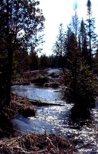
The weather was perfect for backpacking--sunny and cool.
We spent a pleasant afternoon traversing some wetlands. Frogs
sang loudly in one area though there were still patches of
ice along the edges of the water.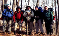
Michael Ugorowski,
Bill Host,
Michael Neiger,
Alex Chard,
and Milton French
prepare to depart.
(Photo by Mary Powell)
We crossed M66 and a few hundred meters to the east of it
was the Jordan River. This was not the Jordan I remembered
from summer hikes along the trail named after it.
Upstream along the pathway the river flows knee deep over
sand and gravel, dividing frequently into multiple channels.
Here, well contained between its banks and swollen by the
spring runoff, it was at least waist deep and flowing forcefully.
Pilings from an old railroad bridge combed the current amplifying
the rushing water sound. Our planned route continued on the
far side of the river, however, and there was a good spot
to camp on the railroad grade there.
We scouted for a reasonable place to cross. The one we chose
had a gravelly bottom visible most of the way across and only
a few logs in the water to climb over.
Michael wrapped his pack and went first, floating it ahead
of him. When he had secured his gear on the far shore, I started
across. The water that had been waist deep on him was closer
to chest deep on me.
He stepped back in seeing that I might need a hand. Fortunately
he caught my pack about the same time the current lifted my
feet from the bottom.... A few strokes of swimming and my
feet hit gravel again.
I was soon standing on the crusty snow watching the next
person negotiate the cold water. Helping each other, everyone
made it across with dry gear except for what we were wearing.
Milton wrote: The
current at the point where the railroad had once crossed
the river was too fast so we headed about 50m upstream to
cross.
Michael put on his bathing suit
and went across first. It was over a meter deep in the middle
with a number of submerged logs.
Next Mary went across. To help
her, Michael took her pack from her in the channel, but
without the pack she lost her footing. She immediately swam
out of the channel to safety in a shallower part of the
river.
The other three crossed safely
and I was the last one to cross. I borrowed someone's tarp
to float my stuff across. In the channel Michael helped
me with my stuff and I made it across safely.
We changed hurriedly, set up camp and brewed some warm drinks.
It seemed like a good occasion for a fire and we built one
on a firepan near the river. While it was not large enough
to provide a great deal of heat, it always FEELS warmer near
the flames. This fire also baked apple crisp for dessert and
dried a lot of socks.
The steady sound of rushing water was very relaxing. At the
end of the evening I lay in my bag just a couple of feet from
the stream watching the moon peeking through the trees and
glinting on the surface of the water. Falling asleep was effortless.
Milton wrote: We
walked back downstream on the east side of the river to
the spot where the grade continues on the east side of the
river and set up camp there.
It was about 6 p.m. when we setup
camp. The area where we camped was sheltered and almost
all of the ground was still snow covered.
We all changed into dry clothes
and hung the wet ones to dry.
Mary used her improved wood stove.
It worked well. She made apple crisp and shared it with
the group.
Due to the trees only some of the
sky could be seen but the moon was still bright once it
got dark.
Around 2 a.m. I woke up and saw
the moon was near setting in the west through the trees.
It was a pretty sight. I put on my shell top to stay warm.
I was using my 15 degree bag that I have had for over 10
years but now the loft is nearly gone.
Morning was again clear and cool....very cool. My boots ,
in which I'd crossed the stream because they'd gotten wet
earlier in the afternoon, were still too soaked and frozen
to put on.
I chose damp socks and the sandals I was SUPPOSED to cross
the stream in.
Milton wrote: In
the morning, I estimated the air temperature was 25 degrees.
Mary measured the river temperature and found it was 48.
Someone said "We almost died yesterday crossing the
river." I think the previous day's river crossing had
scared him. We got underway about 9 a.m.
We had a leisurely breakfast around the fire with a good
bit of joking about the frozen underwear hanging around us.
When we were packed we headed off along the overgrown railroad
grade.
We hadn't gone far when it became necessary to detour around
some private property. Michael did a little map and compass
instruction and we paced off a distance sufficient to clear
the private land, then did a 90 degree turn and brought ourselves
back near the river.
Following two-tracks and railroad grades we made our way
toward Pinney Bridge Campground where there was a possibility
that we would meet with some hikers from the Nepessing group.
Milton wrote: After
another 500m along the overgrown grade we reached a dirt
road. We went north on it a short distance and then east
into a wooded area.
We followed a dirt path a short
distance before starting a bushwhack to the south. We did
this to avoid an area of private land.
We reached a driveway and stopped
for a break while Michael and Mary went to investigate the
private land at the end of the driveway.
We also took a picture of Mary
in her shorts while standing in snow.We headed east along
the driveway a short distance before turning south to bushwhack
down to the river.
After a fairly easy 500m bushwhack
we reached the river where we had lunch. I found a number
of bones just 1m from my pack. We later found out that they
were deer bones.
Our route took us across a beautiful little swamp which was
almost bisected by the railroad grade. New growth was just
emerging everywhere. In the wet areas the leaves of blue flags
were up several inches and ferns were uncurling above the
carpet of leaves.
On the south sides of hills we saw the leaves of trout lilies,
the folded umbrellas of may-apples, wild onions, trailing
arbutus in bud and a few tentative blooms of spring beauty.
On the north side of the hills each depression and shadow
was still filled with snow.
We paused a while at the campground but there was no sign
of the other group so we continued along the trail heading
toward a high narrow ridge that Michael had tentatively selected
from the topo as our bivouac.
Milton wrote: Instead
of returning back to the driveway we voted to hike to Penny
Bridge by bushwhacking along the river. During this bushwhack
we found a virgin white pine tree. It was magnificent.
We left the low area and continued
through a very pretty area of hardwoods on the south side
of the river. After awhile we reached Penny Bridge where
we took a break.
Alex and I were not ready when
they wanted to go so they went ahead to the campground while
we were to follow them there. However we were never told
which way to go.
When we came to the tee in the
trail we decided to try going right. I did not think that
they had gone that way since I did not see them ahead nor
did I see footprints.
Still we continued for 10 minutes
before we turned around and headed back. We planned to go
back to the tee and wait for someone.
We were almost back when we saw
Michael. We followed him to the campground. It turned out
that the campground was almost straight ahead from the path
to the bridge.
We hadn't gone far when someone spotted the almost intact
skeleton of a deer lying off to the side of the trail. Only
a few feet from the bones was a camo baseball cap.
This juxtaposition of artifacts led to some weird supposition
as to what had transpired there. I took out my camera but
there was no way to get a good picture--everything blended
into the leaves.
One thing led to another and we soon had the skeleton "posed"
on a nearby post with the baseball cap on and ourselves in
the foreground for pictures. What can I say? It was late in
the day....maybe a touch of hypoglycemia. 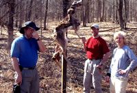
Bill Host,
Alex Chard,
and Mary Powell
try to encourage
Milton French
to shake hands with
Mr. Whitetail.
(Photo by Mary Powell)
Milton wrote: Once
at the campground, we intercepted the NCT. We started following
it east. After some time we stopped for a break at a bend
in the trail.
I found a deer carcass. Michael
came over with a stick and picked up the carcass and then
hung it off a pole next to the trail. There was also a cap
and Michael set it on the head of the deer.
Planning to camp on a hilltop, we picked up several liters
of water apiece at the next stream. A few hundred meters farther
along the path Michael had us make a left into the bush where
we almost immediately began to climb...and climb...and climb.
The extra water was real noticeable here.
When we reached the top the view was nice but not spectacular
and the surrounding terrain didn't match the map. Michael
concluded that the GPS was off or suffering from operator
(that would be me) malfunction.
He cast his eyes on a ridge several hundred meters distant
(with a valley in between) and said, "That's where we
should be." The group's expressions mirrored my thoughts:
"Isn't that ridge just like this one?"
But packs were shouldered and we followed the leader. After
a bit of a walk and another climb we came out on a ridge that
matched the map.
Narrow and a little higher than the last one, it gave us
a nearly 360 degree view of the surrounding countryside--definitely
worth the extra travel.
Milton wrote: We
continued on for about 30 minutes before coming to a small
stream. We stopped there to get water. I found a spot where
I could put my filter at a deeper spot in the stream and
started filtering water.
Some of the others went upstream
to get their water. After filtering we continued down the
trail for a short distance before bushwhacking to the north.
Michael was determined to camp
at the end of a ridge even though it was still some distance
away. We had a significant climb to reach the top of a ridge.
But it was not the one Michael
was looking for so we continued north until we reached a
second ridge. We went 300m east before coming to the end
of the ridge where we decided to camp for the night.
Noting that it was nameless on the map, Michael asked Milton
what we should call it. Milton said, "French Ridge would
be good...."
So we each picked a piece of French Ridge to be our own for
the night, occupying whatever small flat space we thought
would keep us from rolling downhill in the dark. Most of us
decided to forego shelters as the sky was clear--so there
wasn't a lot of setting up to do.
In the deepening twilight we got out our stoves and food
and cooked dinner while the stars came out.
As we sipped the last of our drinks after the meal a great
horned owl queried the familiar, "Who cooks for you?"
first from one quadrant of the darkness then another. Later
we heard a woodcock tirelessly repeating his mating ritual.
It's always nice when you can sleep out under the sky.
Milton wrote: There
was a great view of the Jordan River valley for over 270
degrees of the horizon. I slept with both my fleece and
shell and was warm the entire night. The sky was still clear
that night too and the moon was beautiful.
The next morning was partly cloudy and a chilly breeze blew
across the ridge. Insulated pants were welcome. The combination
of coffee and oatmeal made a warm spot in my midsection.
We savored the view as we ate. Then we packed and headed
downhill from the tip of the ridge.
Finding the trail with little difficulty we headed in the
general direction of Deadman's Hill. For diversion from trail
hiking we took a few shortcuts through the brushy hills. I
soon concluded that raspberries are NOT among the endangered
flora in that area...
Around noon we took a break where a trio of culverts led
the Jordan River under the pathway.
As we rested, Denny Crispell of the Nepessing group hiked
up to us on the trail. We exchanged greetings and he joined
us in relaxing, saying that the rest of the group, 14 in all,
should be along shortly.
Next to appear were a couple of college girls with whom Milton
and Michael quickly became acquainted. After quite awhile
the rest of the group arrived.
Milton wrote: About
9 a.m. the next morning, Michael said that we were leaving
at 9:30 a.m. so be sure that you are ready. But we didn't
quite make the start time.
We started north and then turned
east bushwhacking through the woods. We stopped for a break
next to a stream and continued on toward the Jordan River
until we intercepted the NCT.
We followed the NCT until it turned
east along a dirt road and crossed the Jordan River where
we stopped for lunch.
Toward the end of the lunch break,
two female college students showed up and also stopped for
lunch.
We found their names were Katie
and Allison. Katie had the fish symbol on her water bottle
so I inquired what it meant. I found that both of them are
Christians.
Katie gave me her copy of the KJV
Gideons New Testament Bible. We asked Katie how her trip
was going.
She said "Some sicko hung
a dead deer on a post." We told her that it was Michael.
Their leader, Dave Mansfield, said they'd kept the coffee
warm all evening at the campground in case we showed up.
Both groups shared some highlights of their trips before
parting as mid-afternoon was approaching.
Our party decided another shortcut was in order.
Milton wrote: We
left the river and NCT a short distance before deciding
to bushwhack to save some time compared to following the
trail.
This shortcut involved crossing
a ridge. The north side of the ridge was steep leading down
to a swamp at the bottom.
Apparently the rest of group has
difficulty in steep terrain because it took them a lot longer
to reach the bottom than me. At the foot of the ridge we
traversed northeast for about 400m before reaching higher
ground where we stopped for a break. It was about 3 p.m.
Sunday's sermon: Ephesians 2:8-9.
Michael had me give my Sunday
Sermon. "For by grace are you saved, through faith,
not by works, it is the gift of God, lest any one should
boast".
The text can be divided into
three parts.
The first part is "For by
grace are you saved". Grace is defined as unmerited
favor. God shows his kindness to us as grace even though
we are undeserving.
The second part is "through
faith". God requires us to come to him by faith only
and not through knowledge. God did not write the Bible
as a scientific document with so much overwhelming evidence
that he exists, that no one could doubt his existence.
Instead he desires for us to
accept him because we know from our spirit that it is
the right thing to do. God requires us to choose him by
faith in order to be saved. He gave us the ability to
choose between right and wrong.
The last part is "not by
works, it is the gift of God, lest any one should boast".
We cannot work our way into heaven by doing good deeds,
attending church, donating to charities or by any other
work. Since everyone has different capabilities, God made
it a free gift.
All we have to do is accept it.
To be saved, pray to God asking for forgiveness for sin
and for his leadership in your life. There must be a genuine
change of heart and repentance from sin.
Repentance is a change of direction.
In this case it means that you no longer live a life of
sin. There must be a submission to the leadership of Jesus
Christ.
I concluded the message by asking
if anyone wanted to accept Jesus Christ.
We traversed a couple of moraines and skirted a sizeable
wetland and came out with just a short walk to the loop trail
at the foot of Deadman's Hill where the NCT goes north to
Obrien's Pond which was our planned 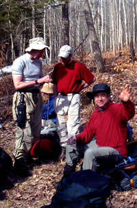 bivouac
area. bivouac
area.
Michael Neiger
and Alex Chard
work out a complex
land nav challenge
as Michael Ugorowski
(background) studies
his map and Bill Host
waves to Mary,
our resident photojournalist
and bone-setter.
(Photo by Mary Powell)
Traveling on the NCT, at one of the spots where the trail
follows a two-track, we found the Jordan running energetically
across the road--beavers had dammed a culvert.
Milton wrote: Following
the message we continued about 200m and again reached the
NCT. We followed the trail until it came to a stream with
a wooden platform built overlooking some springs.
We stopped there for another break.
It was a warm sunny day, beautiful for hiking.
After the break we continued on
until the trail turned right onto a dirt road.
The Jordan River was flowing over
the road since beavers had dammed the culverts that let
the river flow under the road.
We waded through the river but
it was only about 50cm at its deepest. We continued down
the road and then turned north onto a dirt path leading
to a beaver dam.
Just before crossing the dam, we
saw 6 turkeys to the left of the dam.
More wet feet...but less than knee deep this time. Continuing
north, where the trail crosses a marsh on another beaver dam,
we saw several deer and the adjoining wetlands had geese,
ducks, a kingfisher and numerous smaller birds.
We went a bit beyond the pond and looked for a place to camp.
We ended up splitting into two groups camping a hundred meters
or so apart.
Mike U., Bill and Milton chose an open area in the hardwoods
on a slight rise. Michael, Alex and I camped near some cedars
at the edge of a marshy pond.
We hoped to see some wildlife either on the water or along
the ridge across from us which was already backlit by the
setting sun.
Again, putting up shelters seemed unnecessary and we just
spread our sleeping bags in the driest spots we could find.
Milton wrote: After
crossing the dam we stopped and made camp for the night.
Three of the group camped just to the left of the trail
overlooking a large swamp.
The rest camped in a woods
well away from the trail. That night we found the best bear
hanging tree of the trip. It looked like it was almost made
to order for the task.
Over dinner we watched a flock of wild turkeys foraging on
the far shore, the males intermittently strutting and spreading
their tails in classic Thanksgiving fashion.
After dinner Michael and I walked down the trail a little
to get another view of the turkeys.
Then, not ready to read or sleep, I wandered back to Obrien's
Pond to see what the birds there were doing. A flock of geese
were gossiping quietly along one shore.
A few mallard ducks were intent on finding bedtime snacks.
The bent stalks of last year's cattails were decorated at
intervals with red-winged blackbirds.
A cardinal, bright red in the last rays of the sun, sang
cheerfully at the very top of a bare tree. I started back
to camp but was led astray by an old RR grade curving along
the edge of the swamp--it's hard to resist checking out a
path...
Negotiating partially frozen puddles, I followed it to the
far end of the pond. The moon was glinting on the puddles
as I returned.
On the way "home" I stopped by the camp on the
hill and chatted awhile with Mike and Bill. Milton had already
turned in.
When I got back to the swamp I found Alex's bivy already
zipped up and got a sleepy "goodnight " from Michael.
Still not sleepy myself I attributed that to a combination
of: 1) cold feet from icy puddles, 2) coffee with dinner and
3) not wanting to miss the last night in the bush.
I got out the book I'd brought, but the next chapter focused
on a bear attack--not a good thing to read in the woods in
the dark...
So I lay back and listened to the creaking of the trees in
the breeze and to the tentative peeps of the earliest tree
frogs. Snuggled in dry socks inside my bag my toes soon got
warm and sleep came rather quickly.
Milton wrote:
It was mostly clear that night with one cloudy period near
morning. It was the warmest night of the trip. In fact,
I actually removed some layers during the night.
Next morning we lingered by the pond over a leisurely breakfast
until one of the "hill people" came down to get
water and to see what time we were planning to leave.
We toyed briefly with the idea of just disappearing into
the woods, but supplies were running low and obligations came
to mind.
Like all good things, the trip had come to an end--and a
very short hike returned us to our cars.
|