|
Beyond the small circle of light cast by my headlamp is velvety
darkness and the sound of rushing water. We are camped at
the takeout on a portage trail on the Sand River. Alex is
sleeping; Michael and Gail walked downstream looking for moose.
This trip has gotten off to an unusually
idyllic start.
The four of us met yesterday at McDonald's
by the bridge at the Soo and traveled up here together. On
the way we stopped at a bank (Canadian funds), the Trading
Post (maps and fishing stuff), Giovanni's (Italian dinner),
Voyageur Inn (dessert), and then at our favorite gravel pit,
where we camped for the night.
We awoke this morning to sunshine
and went to the Northgate Service Center for breakfast. Taking
our time, we made final gear selections and spotted a couple
of cars at Frater. By then it was time for lunch.
We ate at the Sand River trailhead
and did a little casting with our fishing rigs. Around 2 p.m.
we finally hoisted our packs (with some difficulty as 9 days
of food weighs a bit) and headed down the trail.
Took a couple of neat pictures before
I realized there was no memory card in my camera and returned
it to the trailhead.
After that a couple of hours hiking
brought us to this spot where we spent a pleasant evening
fishing, cooking, and exploring the small falls upstream.
Today has been a little more work.
We started by fording the Sand just below last night's camp.
The river was broad there but had a nice gravel bottom and
low banks. The short swim at the deepest point was chilly
but not difficult. 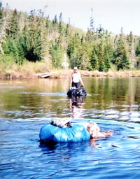
Mary and Gail
ford and swim
the Sand River.
(Photo by Mary Powell)
View Gail Staisil's Photo
Album
We hiked a little way up the Sand River Road, which is gravel,
to the remnants of the Old Sand River Road, which is pretty
well overgrown with trees and brush.
On the former we enjoyed views of distant escarpments, beaver
ponds and wild flowers. On the latter we could see only a
few feet ahead and progress was slow. We thought that was
bad until we reached the point where we planned to bushwhack
over to the Sand again.
Between the river and us was an incredible tangle of swamp.
It was time to look for a place to camp too. We climbed over
fallen trees, balanced on hummocks and crossed rotting logs
over brackish water. We pushed through dense growths of cedar
and edged around the larger ponds.
Michael worked along the bank of the river. The rest of us
were theoretically contouring around on the higher ground
farther back. If there was any "higher ground",
it disappeared quickly. Swarms of bugs followed our every
move, convinced that we had come to provide them with a meal.
Finally, Michael called out that he had found a spot to camp.
Getting a bearing on his voice, we worked our way through
a couple hundred more meters of swamp to what came to be known
as "Punji Stake Camp."
Along the bank of the river Michael had found a rise large
enough to support a few pines, it was overgrown with alders
that industrious beavers had clipped off to short stakes with
pointed ends.
Gail had her hammock. The rest of us scouted around for enough
flat space to spread out our sleeping pads without being impaled
on the stakes.
After a brief swim in the river to remove the sweat and soothe
the bites, we donned our bug gear and got out our stoves to
cook dinner.
Finding adequate bear hangs afterwards was a little tricky,
but by the time the food was situated, dropping temperatures
had thinned out the bugs and the remaining evening was pleasant.
As I got settled in my bag there was the sound of beaver
tail slap from the river, repeated several times as if to
let us know we were in his/her work area.
Today went very well. There were scattered clouds in the
morning and more in the afternoon. We hiked from Punji Stake
Camp up the remnants of the Old Sand River Road to Lady Evelyn
Falls.
The canoeing campsite below the rapids was full of gear.
We knew that Dave Mansfield and Chris Ozminski of the Nepessing
Group were going to be in the area but we thought we had missed
them. Could this be their stuff? 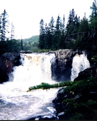
Lady Evelyn Falls
along the
Sand River
(Photo by Mary Powell)
View Gail Staisil's Photo
Album
Walking up the portage trail we found Chris fishing and Dave
enjoying the scenery near the falls. They came up to our camp
as we were getting set up and there was a prolonged and enthusiastic
interchange with Michael about routes, gear, UTMs, map datums,
etc.
As it was pretty obvious that this was "guy talk",
Gail and I retired upstream to swim and wash our hair. By
the time we returned it had been agreed that the parties would
have dinner together and, if possible, it would include fish.
I went to take some pictures of the falls then returned to
camp for fishing gear. Michael said Chris would like to try
some worms, but when I offered them to him as he was casting
into a pool below the falls he said he'd caught the one he
had with a fly.
He moved on downstream and I considered the possibility of
using a fly. I found something in my tackle that looked like
a fly to me and put it on the line with a bobber like Michael
had described the day before.
Not really expecting much, I tried a couple of casts into
the churning pool, which seemed like an unlikely spot for
a fish to be in the first place. On the third throw, low and
behold, there was a fish on the line!
I wound the line back onto my survival rig and, when the
fish was flopping on the rocks at my feet, I contemplated
what to do next, since my fishing instructor was back at camp.
I decided the worst I could do was to ruin the hook.
Picking up the fish, I found it strange to hold something
so cold yet very much alive. I don't like causing pain either
and my efforts to remove the hook obviously did that. Fortunately
the struggle didn't last long.
With one small trout in the bag, I went back to casting,
for awhile, but didn't have any further luck.
Back at camp I found Chris had caught two more trout giving
us a total of four.
Michael demonstrated an easy way of cleaning them. Then Chris
and Dave went to get their dinner stuff.
I wrapped the fish in foil with onions, butter and seasoning,
mixed some biscuit dough and awaited their return. A pleasant
meal followed.
Fresh trout is good even when cooked by an amateur, and the
biscuits came out pretty well too. Of course, being in the
bush favorably influences one's judgment regarding the quality
of food.
As the sun set after the meal, and an evening of conversation,
Chris and Dave headed back to their camp to get ready for
their hike out the next day. Our group settled down to read
or sleep.
Morning dawned with clear skies and the sun soon drove the
heavy fog from the river.
After a leisurely start we began following a heavily overgrown
old logging road to the place where the old Sand River Road
crosses the river.
It was the kind of hiking where you use your entire body
to move forward--stepping over the fallen branches, pushing
aside the standing ones and bending under or crawling over
the horizontal ones.
As the sun rose it got steadily hotter and the bugs became
more aggressive. We waded in the river to cool off and tried
a bit of fishing without success.
We found some remnants of an old lumbering operation including
a large fuel drum and many pieces of cable. There was also
an area where a bear had done some digging, perhaps for grubs
or larva.
By mid afternoon we were tired of the brush and bugs, Having
no need to get to a particular spot we decided to make camp.
We mapped, ate and explored the area.
In the evening we did a bit of recon, looking for an old
road that was on the map but didn't seem to be a part of the
terrain.
The next morning we were up early, refreshed and determined
to cover some ground before the day got too hot.
We bushwhacked up a nearby valley where we had looked for
the road the night before. There was evidence of logging,
remnants of foundations and some old saw logs stacked in the
brush. Now and then we could see where a road might have been.
Farther up the valley we found a huge beaver dam that was
washed out in the middle. We worked our way to the end of
the valley and crossed a saddle into the neighboring watershed.
When we came upon the Sand River road again we saw new excavation
and road building. As we passed Huckson Lake we spoke with
the owner of a small camp along its edge.
He told us that an investor from the States had purchased
several townships and was planning to harvest the lumber there.
That explained the new road. After discussing some inequities
of local politics he offered us a swim from his dock, which
we gladly accepted.
When we had lowered our core temperatures a few degrees,
we thanked him again and continued our trek. After a short
hike on the new road, which stood out as a ragged gash in
the otherwise undisturbed wilderness, we turned off on one
of the many old logging roads that wind through the area.
At some point we missed a turn and, since the sun was getting
low in the west, we got out the GPS to see where we were.
It told us we were just a little over a mile from Vesi Lake
which had been our tentative goal. Heading again in that direction,
we came upon a nameless lake and decided to camp there instead
as it was getting late and we didn't have any particular spot
on Vesi Lake in mind.
Michael and Gale camped close to the water while Alex and
I found a couple of flat spots farther back in the woods.
We all had dinner on a soft patch of sphagnum moss along the
shoreline. Ducks came and went and the loons called to each
other.
We thought perhaps a moose might make an appearance, but
that didn't happen. As the dusk deepened we retired to our
respective shelters and fell asleep to the drone of mosquitoes
outside the netting.
Evening finds us camped on the Black Spruce River at the
fourth falls upstream from its confluence with the Agawa River.
Each of us is surrounded by a dense cloud of mosquitoes and
black flies, which are kept at bay by DEET and bug resistant
clothing.
This is a beautiful place; bluffs of rock in layers of pink
and dark gray are covered with lichens and edged with mixed
forest. The river curves around with the water cascading over
sculptured rocks.
We were going to finish the day by climbing Black Spruce
Mountain but were captured by the beauty of this place when
we forded the river.
Alex is building his "first fire in years" of driftwood
on a base of sand on the ledge below me. The objective of
this exercise is to dry some of his gear that got soaked during
the river crossing.
Gail is across a small cove taking pictures of the waterfall
in the changing light. Michael may finally be getting some
reading in.
We've not worked too hard today, hiked two tracks and ski
trails until we gave in to the temptation to stop by Windy
Lake Lodge.
There we got a warm greeting from the owners, Tom and Shirley,
who have known Michael for many years. We were also treated
to some of Shirley's cooking--a lunch of lake trout shared
by a departing guest.
From the lodge it was only a few miles to the Algoma Central
tracks and the Black Spruce trail that brought us here.
We awoke on Friday to the steady patter of rain on our tarps
and to the hum of mosquitoes just audible above the sound
of the waterfall. The sky was a uniform gray that signaled
prolonged precipitation.
We ate a leisurely breakfast and packed slowly, as we were
only planning to go to the top of Black Spruce Mountain to
camp and take in the views from that height.
There was little use in starting out in a downpour. We started
bushwhacking around 10 a.m. when the rain slacked off to a
drizzle. The climb was moderately strenuous and being in no
rush we did it in intervals.
By 11 a.m. there were patches of blue in the sky. Upon reaching
the top we scouted around for the best views and places to
camp. We picked one of the better sites for lunch--a rocky
ledge that overlooked the curve of the Black Spruce River
and the forest to the south.
Banks of dark clouds competed with the patches of blue and
gusty breezes alternated with periods of damp stillness. After
lunch we selected a campsite from the many possibilities available.
We chose to overlook the confluence of the rivers, the ACR
tracks and the small cabins nearby.
Anyone who became bored with that vista could go "next
door" and scan the power line receding into the distance
for moose and other wildlife. Michael and I set our tarps
on the rocky ledge with the view before us. As it turned out,
Michael's tarp was about 4 feet in front of the resident grouse's
favorite drumming spot.
As he tried for an after-lunch nap, the bird did his thumping
and whirring ritual about every ten minutes. Hard to say if
it was the prospect of an early morning avian alarm clock
or the gusty winds that blew in around dinner that made him
pick up his tarp and move back into the woods before sunset.
It was a lazy afternoon of napping, reading and exploring.
The rocky bluff was covered with blueberry bushes and their
small white bell-shaped flowers attracted fat bumble bees.
There were quite a few pink lady slippers.
A hummingbird visited several times and sandhill cranes flew
by beneath our ledge. We saw the northbound train go past
looking like a toy on the trestle far below. A light rain
fell as we ate dinner.
We sat under our tarps watching the changing view as clouds
came and went and fog moved in over the ground below us. We
turned in early to read and sleep. The night was punctuated
by a series of small thunderstorms.
After breakfast Saturday we descended the mountain in a series
of bushwhacks with short breaks in between.
The sky remained mostly overcast and there was a breeze.
Damp and slightly chilly from the intermittent rain, we weren't
looking forward to fording the Agawa.
Contouring around the hill at one point, we came upon a woodchuck
catching the occasional ray of sun in the doorway of his home
beneath a large pine. He was cute and inquisitive, and Gail
took several pictures.
The river crossing proved to be easy and while there was
still a brisk breeze, the sun came out by the time we gathered
on the far shore. After drying off and changing, we further
warmed up by eating a light lunch in the sunshine by the tracks.
Then we hiked six miles or so north along the rails until
we reached a point where the falls we wanted to see-Parch
Creek Falls--lay to the east.
The bushwhack from the tracks to the falls was not as simple
as it appeared on the map, but after a couple of changes in
bearing we achieved our objective which was definitely worth
the effort. Parch Creek drops about 50 feet over dark rock
bluffs in three separate cascades.
As the falls face west, we got some pictures lit by the evening
sun before setting up camp on a rocky ledge near the top.
The roar of the falls discouraged conversation over dinner
but was definitely soothing to fall asleep to.
Having gotten the lay of the land on the way in, the bushwhack
back to the tracks went smoothly. We arrived in time for a
swim and a snack before the train came.
Flagging it down, we loaded our gear into the baggage car
and moved to the observation area at the back to enjoy the
familiar scenery on the ride south to Frater. It had been
another good trip and we'd identified many possibilities along
the way for future exploration.
Read
another journal...
|